I love Blogging, helping others, making
something out of nothing !!!!!!
Enclave and exclave
Updated on
Edit
Like
Comment
Share
Sign in
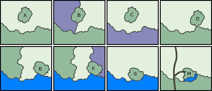
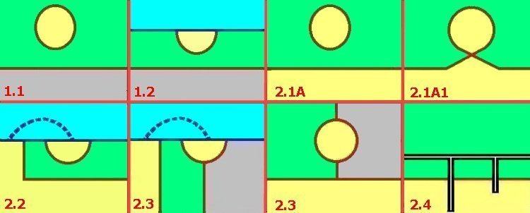
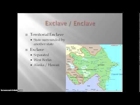
An enclave is a territory, or a part of a territory, that is entirely surrounded by the territory of one other state. Territorial waters have the same sovereign attributes as land, and enclaves may therefore exist within territorial waters. An exclave is a portion of a state or territory geographically separated from the main part by surrounding alien territory (of one or more states). Many exclaves are also enclaves. Enclave is sometimes used improperly to denote a territory that is only partly surrounded by another state. Vatican City and San Marino, enclaved by Italy, and Lesotho, by South Africa are the only completely enclaved states. Unlike an enclave, an exclave can be surrounded by several states.The Azeri exclave of Naxçıvan (Nakhchivan) is an example of an exclave.
Semi-enclaves and semi-exclaves are areas that, except for possessing an unsurrounded sea border, would otherwise be enclaves or exclaves. Enclaves and semi-enclaves can exist as independent states (Monaco, Gambia and Brunei are semi-enclaves), while exclaves always constitute just a part of a sovereign state.
A pene-enclave is a part of the territory of one country that can be approached conveniently — in particular by wheeled traffic — only through the territory of another country. Pene-enclaves are also called functional enclaves or practical enclaves. Many pene-exclaves partially border their own territorial waters (i.e., they are not surrounded by other nations' territorial waters). A pene-enclave can also exist entirely on land, such as when intervening mountains render a territory inaccessible from other parts of a country except through alien territory. A commonly cited example is the Kleinwalsertal, a valley part of Vorarlberg, Austria, that is only accessible from Germany to the north.
Origin and usage
The word enclave is French and first appeared in the mid-15th century as a derivative of the verb enclaver (1283), from the colloquial Latin inclavare (to close with a key). Originally, it was a term of property law that denoted the situation of a land or parcel of land surrounded by land owned by a different owner, and that could not be reached for its exploitation in a practical and sufficient manner without crossing the surrounding land. In law, this created a servitude of passage for the benefit of the owner of the surrounded land. The first diplomatic document to contain the word enclave was the Treaty of Madrid, signed in 1526.
Later, the term enclave began to be used also to refer to parcels of countries, counties, fiefs, communes, towns, parishes, etc. that were surrounded by alien territory. This French word eventually entered the English and other languages to denote the same concept although local terms have continued to be used. In India, the word "pocket" is often used as a synonym for enclave (such as "the pockets of Puducherry district"). In British administrative history, subnational enclaves were usually called detachments or detached parts, and national enclaves as detached districts or detached dominions. In English ecclesiastic history, subnational enclaves were known as peculiars (see also Royal Peculiar).
The word exclave, modeled on enclave, is a logical extension of the concept of enclave.
Characteristics
Enclaves exist for a variety of historical, political and geographical reasons. For example, in the feudal system in Europe, the ownership of feudal domains was often transferred or partitioned, either through purchase and sale or through inheritance, and often such domains were or came to be surrounded by other domains. In particular, this state of affairs persisted into the 19th century in the Holy Roman Empire, and these domains (principalities, etc.) exhibited many of the characteristics of sovereign states. Prior to 1866 Prussia alone consisted of more than 270 discontiguous pieces of territory.
Residing in an enclave within another country has often involved difficulties in such areas as passage rights, importing goods, currency, provision of utilities and health services, and host nation cooperation. Thus, over time enclaves have tended to be eliminated. For example, two-thirds of the then-existing national-level enclaves were extinguished on August 1, 2015, when the governments of India and Bangladesh implemented a Land Boundary Agreement that exchanged 162 first-order enclaves (111 Indian and 51 Bangladeshi). This exchange thus effectively de-enclaved another two dozen second-order enclaves and one third-order enclave, eliminating 197 of the Indo-Bangladesh enclaves in all. The residents in these enclaves had complained of being effectively stateless. Only Bangladesh's Dahagram–Angarpota enclave remained.
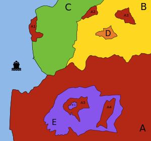
Enclave versus exclave
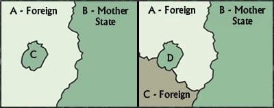
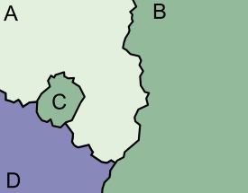
For illustration, in the figure (above), A1 is a semi-enclave (attached to C and also bounded by water that only touches C's territorial water). Although A2 is an exclave of A, it cannot be classed as an enclave because it shares borders with B and C. The territory A3 is both an exclave of A and an enclave from the viewpoint of B. The singular territory D, although an enclave, is not an exclave.
True enclaves
An enclave is a part of the territory of a state that is enclosed within the territory of another state. To distinguish the parts of a state entirely enclosed in a single other state, they are called "true enclaves". A true enclave cannot be reached without passing through the territory of a single other state that surrounds it. Vinokurov (2007) calls this the restrictive definition of "enclave" given by international law, which thus "comprises only so-called 'true enclaves'". Two examples are Büsingen, a true enclave of Germany, and Campione d'Italia, a true enclave of Italy, both surrounded by Switzerland.
The definition of a territory comprises both land territory and territorial waters. In the case of enclaves in territorial waters, they are called maritime (those surrounded by territorial sea) or lacustrine (if in a lake) enclaves. Most of the true national-level enclaves now existing are in Asia and Europe. While subnational enclaves are numerous the world over, there are only a few national-level true enclaves in Africa, Australia and the Americas (each such enclave being surrounded by the territorial waters of another country).
A historical example was West Berlin before the reunification of Germany. Since 1945 all of Berlin was ruled de jure by the four Allied powers. However, the East German government and the Soviet Union treated East Berlin as an integral part of East Germany, so West Berlin was a de facto West German enclave. Also, 12 small West Berlin enclaves, such as Steinstücken, were separated from the city, some by only a few meters.
Enclaved countries
Three nations are completely surrounded by another country:
The Principality of Monaco is not an enclave, although it only borders France, because it possesses a coastline and territorial waters. For the same reason, Canada, The Gambia, and Portugal are also not enclaves.
Historically, four of the Bantustans (or "Black homelands") of South Africa were granted nominal independence, unrecognized internationally, by the Nationalist government from 1976 until their reabsorption in 1994. Others remained under government rule from 1948 to 1994. Being heavily partitioned, various parts of these Bantustans were true enclaves.
To establish jurisdiction, the Scottish Court in the Netherlands, at Camp Zeist near Utrecht, was temporarily declared as sovereign territory of the United Kingdom under Scots law for the duration of the trial of those accused in the Lockerbie bombing, and was therefore an exclave of the United Kingdom and of Scotland, and an enclave within the Netherlands. This was also so during the appeal against the conviction. The court was first convened in 1999, and the land returned to the Netherlands in 2002.
True exclaves
True exclave is an extension of the concept of true enclave. Examples include:
In the United Arab Emirates, four emirates have five true exclaves: Dubai (Hatta), Ajmān (Masfut and Manama), Ras al-Khaimah (the southerly of the emirate's two non-contiguous sections), and Sharjah (Nahwa, also both a true national-level enclave and a counter-enclave).
Llívia is an enclave and exclave of Spain surrounded by France.
Büsingen am Hochrhein is an enclave and exclave of Germany surrounded by Switzerland. The shortest distance from Büsingen's borders to the main portion of German territory is only about 700 metres (about 2,300 ft).
Semi-enclaves/exclaves
Semi-enclaves and semi-exclaves are areas that, except for possessing an unsurrounded sea border, would otherwise be enclaves or exclaves. Semi-enclaves can exist as independent states that border only one other state, such as Monaco, the Gambia and Brunei. Vinokurov (2007) declares, "Technically, Portugal, Denmark, and Canada also border only one foreign state, but they are not enclosed in the geographical, political, or economic sense. They have vast access to international waters. At the same time, there are states that, although in possession of sea access, are still enclosed by the territories of a foreign state." Therefore, a quantitative principle applies: the land boundary must be longer than the coastline. Thus a state is classified as a sovereign semi-enclave if it borders on just one state, and its land boundary is longer than its sea coastline.
Vinokurov affirms that "no similar quantitative criterion is needed to define the scope of non-sovereign semi-enclaves/exclaves." Examples include:
Sometimes, administrative divisions of a country, for historical or practical reasons, caused some areas to belong to one division while being attached to another.
Pondicherry district, of the Union Territory of Puducherry, is made of 12 non-contiguous parts, many of them true enclaves entirely surrounded by the state of Tamil Nadu. Before Pondicherry, along with the other territories of French India, was absorbed into India in 1954, they were enclaved within the Union of India, and before that the British Raj. Also a legacy of the French colonial period, the Mahe district is made of 3 non-contiguous parts enclaved within the state of Kerala.
The counties of Scotland before reorganisation in 1889 included dozens of exclaves. This was especially notable in the case of Cromartyshire, which was split into at least nine parts spread across Ross-shire.
The French department of Pyrénées-Atlantiques, in the southwest of France, surrounds two enclaves of the neighbouring department of Hautes-Pyrénées.
The French department of Vaucluse has a rather large exclave to its southeast within the Drôme department — the canton of Valréas (historically known as Enclave des Papes).
San Colombano al Lambro is an exclave of the province of Milan at the junction between the Pavia and Lodi provinces. The exclave arose when the province of Lodi was carved out of the province of Milan, but a referendum in San Colombano indicated the locals' wish to stay in Milan. As a result, the commune is the only wine-producing area in the mostly urbanized province of Milan.
In the United States:
A portion of Ellis Island is an exclave of New York City within the boundaries of Jersey City, and therefore of New York State within the boundaries of New Jersey.
Jeddito, Arizona lies within a 121-square-kilometre (47 sq mi) exclave of the Navajo Nation. This exclave is surrounded by territory of the Hopi Reservation, which is itself surrounded by the Navajo Nation.
"Practical" enclaves, exclaves and inaccessible districts
The term pene-exclave was defined in Robinson (1959) as "parts of the territory of one country that can be approached conveniently — in particular by wheeled traffic — only through the territory of another country." Thus, a pene-exclave has land borders with other territory but is not completely surrounded by the other's land or territorial waters. Catudal (1974) and Vinokurov (2007) further elaborate upon examples, including Point Roberts. "Although physical connections by water with Point Roberts are entirely within the sovereignty of the United States, land access is only possible through Canada."
Pene-enclaves are also called functional enclaves or practical enclaves. They can exhibit continuity of state territory across territorial waters but, nevertheless, a discontinuity on land, such as in the case of Point Roberts. Along rivers that change course, pene-enclaves can be observed as complexes comprising many small pene-enclaves. A pene-enclave can also exist entirely on land, such as when intervening mountains render a territory, although geographically attached, inaccessible from other parts of a country except through alien territory. A commonly cited example is the Kleinwalsertal, a valley part of Vorarlberg, Austria, that is only accessible from Germany to the north, being separated from the rest of Austria by high mountains traversed by no roads. Another example is the Spanish village of Os de Civís accessible from Andorra.
Hence, such areas are enclaves or exclaves for practical purposes, without meeting the strict definition. Many pene-exclaves partially border the sea or another body of water, which comprises their own territorial waters (i.e., they are not surrounded by other nations' territorial waters). Because they border their own territorial waters in addition to a land border with another country, they are not true exclaves. Still, one cannot travel to them on land without going through another country. Attribution of a pene-enclave status to a territory can sometimes be disputed, depending on whether the territory is considered to be practically inaccessible from the mainland or not.
Point Roberts, Washington, is an unincorporated community in Whatcom County—located on the southernmost tip of the Tsawwassen Peninsula, south of Delta, British Columbia, Canada—that can be reached by land from the rest of the United States only by traveling through Canada.
Vermont has two pene-enclaves with Canada. Province Point, a few kilometres to the northeast of the town of East Alburgh, Vermont, is the southernmost tip of a small promontory approximately 2 acres (1 ha) in size (45°0′48.07″N73°11′35.72″W). The promontory is cut through by the US-Canada border; as such the area is a practical enclave of the United States contiguous with Canada. Similarly, the southern point of Province Island (45°0′15″N72°13′52″W), a small island mostly in the Canadian province of Quebec, crosses into the American state of Vermont. It is situated in Lake Memphremagog, near Newport, Vermont.
Walvis Bay, now part of Namibia, was a pene-exclave of the Cape Colony in German South-West Africa, created in 1878. It became part of the Cape Province of the Union of South Africa in 1910, but from 1922, it was administered as a de facto part of South-West Africa, a League of Nations Mandate. In 1977, it was separated from that territory and re-integrated into the Cape Province. South Africa did not relinquish sovereignty over Walvis Bay until 1994, nearly four years after Namibia's independence.
Subnational "practical" enclaves, exclaves and inaccessible districts
The Romanian village of Nămoloasa (Galaţi county) can be accessed only through Vrancea county (where there is a bridge over the Siret River) because it is separated by the Siret River from the rest of Galaţi county.
The southern part of the Province of Venice, Veneto, can be reached directly from the rest of the province only by boat. By land it can be reached only traveling through the Province of Padua because territorial continuity with the main part of the province exists only through some unconnected islands and islets.
The community of East Kemptville, Nova Scotia, Canada, is part of the Municipality of Argyle, but it can only be reached by road from the rest of the municipality by travelling through the Municipality of Yarmouth or the Municipality of Shelburne. The latter route also requires travelling through the Municipality of Barrington.
In the United States:
Several portions of land on the New Jersey side of the Delaware River belong to Delaware. Within the Twelve-Mile Circle, Delaware's border extends to the low-water mark across the river. South of the Circle, the Delaware-New Jersey border follows the middle of the river and bay.
The city of Carter Lake, Iowa is separated from the rest of the state of Iowa by the Missouri River, which changed course during a flood in 1877, cutting the city off from the rest of the state. It is now only accessible through Omaha, Nebraska.
The village of Kaskaskia, Illinois, the state's first capital, is separated from the rest of Illinois by the Mississippi River due to a flood in 1881, which shifted the river to flow east of the town, rather than west. This resulted in the only access to the town being from Missouri.
The Upper Peninsula of Michigan is separated from the Lower Peninsula by the Straits of Mackinac, so until construction of the Mackinac Bridge, the only land routes between them were through the states of Wisconsin, Illinois, and Indiana, or through the Canadian province of Ontario,
It is possible for an enclave of one country to be completely surrounded by a part of another country that is itself an enclave of the first country. These enclaves are sometimes called counter-enclaves.
The Dutch municipality of Baarle-Nassau has seven exclaves in two exclaves of the Belgian municipality of Baarle-Hertog.
The former complex of enclaves at Cooch Behar district included 24 second-order enclaves and one small third-order enclave called Dahala Khagrabari #51: a piece of India within Bangladesh, within India, within Bangladesh. The Indo-Bangladesh enclaves were exchanged on 31 July 2015 by the ratified Land Boundary Agreement, and Dahala Khagrabari was ceded to Bangladesh.
The Portuguese town of Estremoz is made up of two civil parishes (freguesias): the small Santo André and the big Santa Maria. Santo André corresponds to the old town (located inside the medieval walls), but excludes the citadel, which is an enclave inside the old town; the citadel belongs to Santa Maria, which also includes the entire new town (outside the walls) and the vast rural area around it. Thus, Santa Maria has an enclave (Santo André, the old town) with a second-order enclave inside it (the citadel).
Ethnic enclaves
An ethnic enclave is a community of an ethnic group inside an area in which another ethnic group predominates. Ghettos, Little Italys, barrios and Chinatowns are examples. These areas may have a separate language, culture and economic system.
Székely Land is a Hungarian ethnic enclave within Romania, with its people calling themselves Székely. Originally, the name Székely Land denoted an autonomous region within Transylvania. It existed as a legal entity from medieval times until the Austro-Hungarian Compromise of 1867, when the Székely and Saxon seats were dissolved and replaced by the county system. Along with Transylvania, it became a part of Romania in 1920, according with the Treaty of Trianon signed on 4 June 1920 at the Grand Trianon Palace in Versailles, France. In 1938–1940, during World War II, post-Trianon Hungary temporarily expanded its territory and included some additional territories that were formerly part of pre-war Kingdom of Hungary, under Third Reich auspices, the Second Vienna Award. It was later reduced to boundaries approximating those of 1920 by the peace treaties signed after World War II at Paris, in 1947. The area was called Magyar Autonomous Region between September 8, 1952 and February 16, 1968 a Hungarian autonomous region within Romania, and today there are territorial autonomy initiatives to reach a higher level of self-governance for this region within Romania.
The 2008 film Silent Light depicts a Mennonite Flemish sect living within the Mexican state of Chihuahua, who speak a dialect called Plautdietsch.
There are several Serb enclaves in Kosovo where the institutions of Kosovo are not fully operational due to disputes.
Extraterritoriality
diplomatic missions, such as embassies and consulates, as well as military bases, are usually exempted from the jurisdiction of the host country, i.e., the laws of the host nation in which an embassy is located do not typically apply to the land of the embassy or base itself. This exemption from the jurisdiction of the host country is defined as extraterritoriality. Areas and buildings enjoying some forms of extraterritoriality are not true enclaves since, in all cases, the host country retains full sovereignty. In addition to embassies, some other areas enjoy a limited form of extraterritoriality.
Palazzo Malta and the Villa del Priorato di Malta, the headquarters of Sovereign Military Order of Malta in Rome. In addition to extraterritoriality, Italy recognizes the exercise by SMOM of all the prerogatives of sovereignty in its headquarters. Therefore, Italian sovereignty and SMOM sovereignty uniquely coexist without overlapping.
By treaty of 2 November 1929, Czechoslovakia obtained the lease for 99 years of two plots of land (in the Moldauhafen and in the Saalehafen), both within the perimeter of the free port of Hamburg. Another plot, in the Peutehafen, was purchased by the Czechoslovak government in 1929; this plot lies just outside the free-port perimeter.
Saalehafen – approximately 2 ha of land on Hallesches Ufer, on the southeastern bank of the Saalehafen
Moldauhafen – approximately 0.5 ha of land on Dresdener Ufer, on the southeastern bank of the Moldauhafen
Peutehafen – the narrow peninsula between the Peutekanal and the Peutehafen dock, comprising 8.054 ha of land and 0.5 ha of water surface
In Szczecin, Poland, a similar provision existed following the Treaty of Versailles for Czechoslovakia to have access to the harbor, which until the end of World War II was located in Germany. From 1945, when Szczecin became part of Poland, Czechoslovakia possessed no extraterritorial rights there. It appears that the German concession ceased at the end of the war and that no successor paid attention to the pre-war rights that Czechoslovakia had under the Versailles Treaty. Neither the Polish nor the occupying Russians appear to have assumed any of Germany's pre-war liabilities. Czechoslovakia gave up the rights to its territory in Szczecin under an agreement signed on 13 January 1956.
Saimaa Canal: the longitudinal half of the canal in Russia is leased by Finland until 2063. Russian law is in principle valid, but in reality Finland maintains the area.
Land owned by a foreign country
Some areas of land in a country are owned by another country and in some cases it has special privileges, such as being exempt from taxes. These lands are not enclaves and do not have extraterritoriality since, in all cases, there is no transfer of sovereignty.
The Normandy American Cemetery and Memorial in Normandy, France, which contains the graves of 9,386 American military dead, most of whom died during the landings and ensuing operations of World War II, owned by the United States of America.
Pointe du Hoc, 13-hectare site of a memorial and museum dedicated to the World War II Normandy landing at Omaha Beach, transferred by France to American control on 11 January 1979.
The Suvorov Memorial, near Göschenen in central Switzerland, was erected in 1899 by the Russian Empire. The 563 m² area (449 m² rock and 114 m² access road) is Parcel No. 725 of the land register of Andermatt, owned by the Russian Embassy in Berne. The parcel is Swiss territory and fully subject to Swiss law.
The Vimy Memorial in France, which commemorates the Battle of Vimy Ridge. The French government permanently granted a land area of about 91 ha (220 acres) to Canada as a war memorial in 1922 in recognition of Canada's military contributions in World War I in general and at Vimy Ridge in particular.
Two cemeteries on the Outer Banks of North Carolina, United States, one on Ocracoke Island and one on Hatteras Island in the town of Buxton, are owned by the United Kingdom. Both contain the graves of British seamen whose bodies washed ashore after World War II U-boat attacks that occurred on 10 April (San Delfino – one body) and 11 May 1942 (HMT Bedfordshire – 5 bodies). Four graves are at Ocracoke and two at Buxton; three of the bodies were never identified; one of them could be that of a Canadian seaman. The plot of land at Ocracoke "has been forever ceded to England" and is maintained by the U.S. Coast Guard. The plot was leased to the Commonwealth War Graves Commission for as long as the land remained a cemetery. The graves on Hatteras Island are maintained by the U.S. National Park Service.
The Captain Cook Monument at Kealakekua Bay and about 25 square feet (2.3 m2) of land around it in Hawaii, United States, the place where James Cook was killed in 1779, is owned by the United Kingdom. An historian on the occasion of the monument's 50th anniversary recorded in 1928 that the white stone "obelisk monument [was] erected to the memory of Captain Cook, about 1876, and on land deeded outright to the British Government by Princess Likelike, sister of King Kalakaua, about the same year, so that that square is absolute British Territory." Hawaii was a sovereign nation at the time. According to a recent writer, "The land under the monument was deeded to the United Kingdom in 1877 and is considered as sovereign non-embassy land owned by the British Embassy in Washington DC. ... the Hawaiian State Parks agency maintained that as sovereign British territory it was the responsibility of the UK to maintain the site."
Tiwinza in Peru: In the 1998 peace agreement following the 1995 Cenepa War, Peru ceded to Ecuador the property, but not the sovereignty, of one square kilometer within Tiwinza (where 14 Ecuadorian soldiers were buried). Ecuador had established a frontier military outpost in Tiwinza, an area that was specified in the agreement as belonging to Peru.
The land under the John F. Kennedy memorial at Runnymede, United Kingdom was transferred from the Crown Estates to the United States of America by the John F. Kennedy Memorial Act 1964 (an Act of the UK Parliament) however it is in the care of the UK-based Kennedy Memorial Trust.
The Tomb of Suleyman Shah (the burial place of Suleyman Shah, the grandfather of Osman I, the founder of the Ottoman Empire) situated in Aleppo Governorate, Syria, is the property of Turkey. Article 9 of the Treaty of Ankara signed between France and Turkey in 1921, provides that the tomb "shall remain, with its appurtenances, the property of Turkey, who may appoint guardians for it and may hoist the Turkish flag there".
National railway passing through another state's territory
Changes in borders can make a railway that was previously located solely within a country traverse the new borders. Since diverting a railway is expensive, this arrangement may last a long time. This may mean that doors on passenger trains are locked and guarded to prevent illicit entry and exit while the train is temporarily in another country. Borders can also be in the "wrong" place, forcing railways into difficult terrain.
Examples include:
Salzburg to Innsbruck (Austria) (passes Rosenheim, Germany). A railway line within Austria exists as well, but trains take about 1.5 hours longer than across German territory.
Trains from Neugersdorf, Saxony to Zittau pass Czech territory at Varnsdorf, while Czech trains from Varnsdorf to Chrastava pass through German territory at Zittau, and then a small part of Polish territory near the village of Porajów.
Trains from Görlitz to Zittau, Germany, pass the border river Neisse several times (see Oder–Neisse line); the railway station for Ostritz, Germany, lies in Krzewina Zgorzelecka, Poland.
Belgrade–Bar railway crosses into Bosnia and Herzegovina for 9 kilometres (5.6 mi), between stations Zlatibor and Priboj (both in Serbia). There is one station, Štrpci, but there are no border crossing facilities and trains do not call at the station.
The Knin – Bihać railway between Croatia and Bosnia is split by the Croatian–Bosnian border several times. Similarly, the Savski Marof – Imeno railway was split by the Slovenian–Croatian border several times.
The local trains on the Burgenlandbahn in Austria cross the area of Hungary at Sopron. During the era of the Iron Curtain, the trains had their doors locked as they traversed Hungarian territory.
The Hochrheinbahn (Upper Rhine Railway) from Basel via Waldshut to Schaffhausen is part of the Deutsche Bahn network, and is mostly in Germany, but the two ends are in Switzerland and it is only connected with the rest of the German railway network via Switzerland. At both Basel and Schaffhausen the railway has extraterritorial status: one can travel by train to and from the rest of Germany without going through Swiss customs. See Basel Badischer Bahnhof.
Similarly, during the Cold War, underground lines in West Berlin ran under parts of East Berlin. Ghost stations (German: Geisterbahnhöfe) were stations on Berlin's U-Bahn and S-Bahn metro networks that were closed during this period of Berlin's division.
The Belgian Vennbahn (now closed) lies on a narrow strip of Belgian territory running through Germany, creating five German exclaves.
The railway between France and Italy briefly leaves France to enter Monaco in a 150-metre tunnel before entering France once more.
The former Soviet republics have numerous examples:
Belarus/Lithuania: Adutiškis railway station straddles the Lithuania/Belarus border. Trains pass through Lithuanian territory while traveling to and from Belarus, and platforms are in both Belarus and Lithuania. The station is now mainly used for freight.
A very short length of the Syrian Homs–Tripoli line crosses the border into Lebanon. This happens because the railway was built before this border was defined.
Bolivia is landlocked and has no access to the sea, but a rail route runs through Chile from La Paz to the port of Arica on the Pacific Ocean. The rail route was built by Chile under the Treaty of Peace and Friendship of 1904 between Chile and Bolivia, with the Bolivian section transferred to Bolivia after 15 years. Bolivia enjoyed duty-free use of the railway and the ports connected.
Due to inability to agree in 1963 on a shorter route through easy terrain, the iron ore railway in Mauritania originally had to use a longer route through a tunnel (built through 2 km of solid granite) near Choum to avoid the territory of Spanish Sahara. The tunnel is no longer in use and trains now use the shorter route through 5 km of Western Saharan territory controlled by the Polisario Front.
The shortest and straightest route for a proposed east–west high-speed railway in Austria through Linz, Salzburg and Innsbruck would pass under some mountains belonging to Germany.
In 2013, the shortest railway route from coal mines at Tete to a port at Nacala passes through Malawi. A route through all-Mozambique territory is roundabout.
In order to avoid such a trans-border arrangement, the United States made the Gadsden Purchase of land from Mexico, on which it was planned to build a southern route for the transcontinental railroad. Owing to the topography of the area, acquisition of the land was the only feasible way to construct such a railroad through the southern New Mexico Territory.
In 1928, Congo (Belgium) and Angola (Portugal) exchanged some land to facilitate the new route of the railway to Congo-Kinshasa.
Highway of one state passing through another state's territory
This arrangement is less common as highways are more easily re-aligned. Examples include:
Various roads crossing the border back and forth between the Republic of Ireland and Northern Ireland. The N54 in County Monaghan, Ireland twice becomes the A3 in County Fermanagh, NI, before continuing as the N54. Similarly, the N53 in Monaghan passes through County Armagh, NI as the A37, before resuming as the N53 at the border between Monaghan and County Louth, Ireland. No national or county border signs are present.
Congo Pedicle road: built to provide access for Zambia's Luapula Province to the Copperbelt through 70 kilometres (43 mi) of territory of the DR Congo, requiring a change in driving on the left to driving on the right.
Between 1963 and 2002 the N274 road from Roermond to Heerlen, part of Dutch territory, passed through the German Selfkant, which had been annexed by the Netherlands after the Second World War but returned to Germany in 1963.
Close to Narvik, a road from Norway twice enters and leaves Swedish territory, following the southern shore of the Kjårdavatnet lake. It does not connect with any other Swedish road in either location before it enters Norwegian land once more.
Road 402 between Podsabotin and Solkan in Slovenia, built when Slovenia was a state of Yugoslavia, passes through part of Italy. The road is confined by high concrete walls topped by fences; as Slovenia and Italy are now both signatories to the Schengen agreement, the barriers are little more than historical curiosities.
The Saatse Boot Road in Estonia, between the villages of Lutepää and Sesniki, passes through Russian territory. The stretch of road passing through Russia is flanked by barbed wire fences and guard towers. Stopping and/or getting out of one's vehicle on the stretch of road is forbidden; the rule is enforced by Russian border guards.
The road from Dubai to the tourist spot of Hatta, an exclave of the emirate of Dubai, passes through a small stretch of Omani territory.
East Richford Slide Road in the US state of Vermont crosses in to the Canadian province of Québec for a distance of approximately 100 meters (300 feet) before returning to the United States.
The D8 coastal highway of Croatia passes through a small section of Herzegovina territory, at the Herzegovinian town of Neum, as it heads south from Split to Dubrovnik.
In Guinea, where 20 km long tunnel(s) through a hillspur at Naigaya (elevation 411 metres (1,348 ft)), Sicourou, Bokariadi and Feraya might be avoided by crossing the border into Sierra Leone at Yana (elevation 87 metres (285 ft)).
Senegal is practically and inconveniently divided in two by the sovereign territory of Gambia. The easiest way to travel from northern Senegal to the southern Casamance region is through Gambia via the Trans-Gambia Highway, with a connecting ferry being the only way to cross the Gambia River. The fare for the ferry crossing is a source of contention between the two countries. In 2015, a road bridge is under construction.
The highway between Bishkek and Issyk Kul, both in Kyrgyzstan, skirts the border with Kazakhstan, with the highway and the border crossing each other for short distances at various points.
Subnational highway passing through other internal territory
India, a quasi-federal republic, has numerous such examples:
The highway connecting Guwahati (capital of Assam state) to Silchar (a city in Barak valley of Assam) passes through Meghalaya state.
Kota, a city in Rajasthan surrounded by territory of Madhya Pradesh, is connected to other parts of Rajasthan by roads passing through Madhya Pradesh.
Gwalior (Madhya Pradesh) is connected to few other cities of Madhya Pradesh by highways passing through Uttar Pradesh, covering the city of Jhansi.
United States:
Interstate 684, connecting various points in New York State, passes through Connecticut near Kensico Reservoir and Westchester County Airport but is maintained entirely by New York State. Motor vehicles cannot enter from nor exit to Connecticut roads, even though a portion of the highway is owned by Connecticut.
A portion of New York State Route 17/Interstate 86 passes through South Waverly, Pennsylvania but is maintained entirely by New York State. This includes the roadway and traffic lights at the interchange with US Route 220 and a short portion of Pennsylvania Route 199. Nevertheless, Pennsylvania police enforce traffic laws on this short stretch, where there is one overpass built and owned by Pennsylvania.
A 2.0 miles (3.2 km) portion of New Hampshire Route 153 runs along the border with and briefly passes through Parsonsfield, Maine as it sweeps around the eastern shore of Province Lake.
Hopkins Road north of Newark, Delaware, briefly enters Pennsylvania where the Twelve-Mile Circle meets the Mason–Dixon Line. The road is maintained by Delaware, and it appears that at one time Arc Corner Road in Pennsylvania may have intersected here. Further east, Beaver Dam Road enters Chadds Ford Township, Pennsylvania at the intersection of Beaver Valley Road and re-enters Delaware about 0.5 miles later. The section of road in Pennsylvania is in rough shape, and it is unclear who is supposed to maintain this section.
Turkey:
The main road for travel to Bartın via Zonguldak actually crosses Bartın first, traverses Zonguldak a short distance, then returns to Bartın.
Border transport infrastructure
Several bridges cross the rivers Oder and Neisse between Germany and Poland. To avoid needing to coordinate their efforts on a single bridge, the two riparian states assign each bridge to one or the other; thus Poland is responsible for all maintenance on some of the bridges, including the German side, and vice versa.
The Hallein Salt Mine crosses from Austria into Germany. Under an 1829 treaty Austria can dig under the then-Kingdom of Bavaria. In return some salt has to be given to Bavaria, and up to 99 of its citizens can be hired to work in the Austrian mine.
The twin town of TornioHaparanda or HaparandaTornio lies at the mouth of river Tornio, Tornio on the Finnish side and Haparanda on the Swedish side. The two towns have a common public transportation, as well as cultural services, fire brigade, sports facilities etc.
The Basel Badischer Bahnhof is a railway station in the Swiss city of Basel. Although situated on Swiss soil, because of the 1852 treaty between the Swiss Confederation and the state of Baden (one of the predecessors of today's Germany), the largest part of the station (the platforms and the parts of the passenger tunnel that lead to the German/Swiss checkpoint) is treated administratively as an inner-German railway station operated by the Deutsche Bahn. The shops in the station hall, however, are Swiss, and the Swiss franc is used as the official currency there (although the euro is universally accepted). The Swiss post office, car rental office, restaurant and a cluster of shops are each separately located wholly within a surrounding station area that is administered by the German railway. The customs controls are located in a tunnel between the platforms and the station hall; international trains which continue to Basel SBB usually have on-board border controls.
As a legacy of the British colonial period, the Malaysian rail network had its southern terminus at Tanjong Pagar railway station in central Singapore. The land on which the station and the rail tracks stood was leased to Keretapi Tanah Melayu, the Malaysian state railway operator. Consequently, Malaysia had partial sovereignty over the railway land. Passengers had to clear Malaysian customs and immigration checks at Tanjong Pagar before boarding the train to Malaysia, even after Singapore shifted its border control facility to the actual border in 1998 and objected to the continued presence of Malaysian officials at the station. After a 20-year long dispute, the station was closed in 2011 and the railway land reverted to Singapore. A remnant of the rail corridor is still in use; KTM trains now terminate at Woodlands Train Checkpoint in northern Singapore near the border, which houses Malaysian and Singaporean border controls for rail passengers.
The Hong Kong–Shenzhen Western Corridor serves as a crossing point between Hong Kong and mainland China. The immigration checkpoints for both regions, namely the Shenzhen Bay Control Point for Hong Kong and the Shenzhen Bay Port for mainland China, share a facility located on the Shenzhen side of the bridge. The service building portion pertaining to Hong Kong, along with the connecting bridge, is leased to Hong Kong and falls under its jurisdiction. This arrangement is set to continue until 30 June 2047.