
 | ||
University of michigan study details potential impacts of straits of mackinac oil spill
The Straits of Mackinac (/ˈmækᵻnɔː/ MAK-in-aw) is a narrow waterway in the U.S. state of Michigan, between Michigan's Lower and Upper Peninsulas. The Straits of Mackinac connect two of the Great Lakes, Lake Michigan and Lake Huron. The straits are five miles (8.0 km) wide and 20 fathoms (120 ft; 37 m) deep. Hydrologically, the two connected lakes can be considered one, which is called Lake Michigan–Huron. Historically, the region around the Straits was known by the native Odawa people as Michilimackinac. The Straits of Mackinac is "whipsawed by currents unlike anywhere else in the Great Lakes."
Contents
- University of michigan study details potential impacts of straits of mackinac oil spill
- Map of Straits of Mackinac Michigan USA
- History
- Today
- Enbridge pipeline
- References
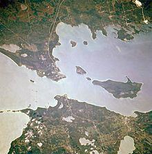
Map of Straits of Mackinac, Michigan, USA
History
The Straits of Mackinac is a major shipping lane, providing passage for raw materials and finished goods and connecting, for instance, the iron mines of Minnesota to the steel mills of Gary, Indiana. Before the railroads reached Chicago from the east, most immigrants arrived in the Midwest and Great Plains by ships on the Great Lakes. The straits is five miles (8 km) wide at its narrowest point, where it is spanned by the Mackinac Bridge. Before the bridge was built, car ferries transported vehicles across the straits. Today passenger-only ferries carry people to Mackinac Island, which does not permit cars. Visitors can take their vehicles on a car ferry to Bois Blanc Island.
Islands in the Straits of Mackinac include the two populated islands, Bois Blanc and Mackinac, and two that are uninhabited: Round and St. Helena islands. At 11 miles (18 km) in length, Bois Blanc is the largest island in the straits.
The straits are shallow and narrow enough to freeze over in the winter. Navigation is ensured for year-round shipping to the Lower Great Lakes by the use of icebreakers.
The straits were an important Native American and fur trade route. Located on the southern side of the straits is the town of Mackinaw City, the site of Fort Michilimackinac, a reconstructed French fort founded in 1715, and on the northern side is St. Ignace, site of a French Catholic mission to the Indians, founded in 1671. The eastern end of the straits was controlled by Fort Mackinac on Mackinac Island, a British colonial and early American military base and fur trade center, founded in 1781.
Today
The straits are patrolled by a detachment of the United States Coast Guard based at Graham Point, St. Ignace. A shipping channel through the winter ice is maintained by the Coast Guard's Great Lakes icebreaker, USCGC Mackinaw, based in Cheboygan near the eastern edge of the Straits. This vessel went into service during the 2005/06 ice season.
Most of the Straits have been set aside by the state of Michigan as the Straits of Mackinac Shipwreck Preserve, a riparian public space dedicated to those personnel who were lost aboard the boats and ships that sank in these dangerous shipping lanes.
Lighthouses in the Straits of Mackinac include:
Enbridge pipeline
West of the iconic Mackinac Bridge is Enbridge's pipeline, called Enbridge Line 5, which was built in 1953 as an extension of the one thousand one hundred and fifty miles (1,850 km) Interprovincial Pipe Line Company line bringing oil from the Alberta oil sands to Lake Superior. The 1953 pipeline enters the Straits of Mackinac water on the north shore at St. Ignace, Michigan and lies along the bottom of the Straits which is nearly two hundred and fifty feet (76 m) in places. By 2013 Enbridge had increased the "maximum capacity on the lines to 540,000 barrels per day." In selling the idea of the pipeline to residents living near the Straits, the pipeline developers claimed, it was "essential to the defense of the United States and the whole North American continent". Mackinac pipes were specifically engineered to withstand the Straits’ brutal underwater environment. Even some of the company’s staunchest critics concede the twin lines, old as they may be, remain an engineering marvel."