
Source elevation 438 m | Length 1,130 km | |
 | ||
Similar Niokolo‑Koba National Park, Kunta Kinteh Island, Senegal River, Abuko Nature Reserve, Albert Market | ||
The gambia gambia river travel doc
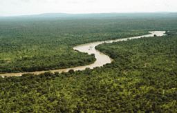
The Gambia River (formerly known as the River Gambra) is a major river in West Africa, running 1,120 kilometres (700 mi) from the Fouta Djallon plateau in north Guinea westward through Senegal and the Gambia to the Atlantic Ocean at the city of Banjul. It is navigable for about half that length.
Contents
Map of River Gambie
The river is strongly associated with The Gambia, the smallest country in mainland Africa, which consists of little more than the downstream half of the river and its two banks.
From the Fouta Djallon, the river runs northwest into the Tambacounda Region of Senegal, where it flows through the Parc National du Niokolo Koba, then is joined by the Nieri Ko and Koulountou before entering the Gambia at Fatoto. At this point the river runs generally west, but in a meandering course with a number of oxbows, and about 100km from its mouth it gradually widens, to over 10km wide where it meets the sea.
Near the mouth of the river, near Juffure, is Kunta Kinteh Island, a place used in the slave trade which is now a UNESCO World Heritage Site.
The aquatic fauna in the Gambia River basin is closely associated with that of the Sénégal River basin, and the two are usually combined under a single ecoregion known as the Senegal-Gambia Catchments. Although the species richness is moderately high, only three species of frogs and one fish are endemic to this ecoregion.
Oysters are harvested from the River Gambia by women and used to make oyster stew, a traditional dish in the cuisine of Gambia.