
Country Scotland Area 958.3 km² | County town Cromarty | |
 | ||
Chapman code ROC (as part of Ross and Cromarty) | ||
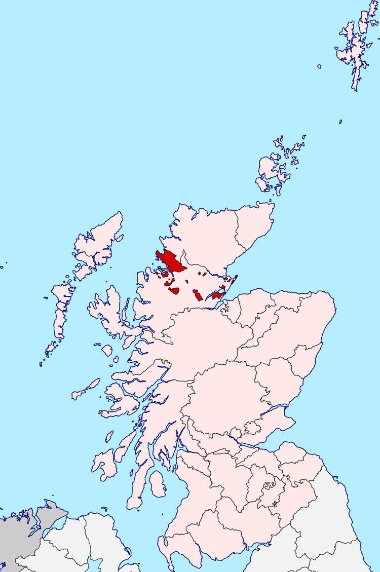
Cromartyshire is a historic county in the Highlands of Scotland, comprising the medieval "old shire" around the county town of Cromarty and 22 exclaves transferred from Ross-shire in the late 17th century. The largest part, six times the size of the old shire, is Coigach, northwest from Ullapool. In 1890, Cromartyshire was merged with Ross-shire into the administrative county of Ross and Cromarty. In 1975, the resulting county was combined with Caithness, Inverness-shire, Nairnshire, Sutherland, and parts of Argyllshire and Morayshire to form the Highland council area.
Contents
Cromartyshire
History
The medieval sheriffdom of Cromarty encompassed a single tract on the north of the Black Isle peninsula. The sheriffdom was hereditary in Clan Urquhart. It comprised the parish of Cromarty; most of the adjacent parish of Kirkmichael, excluding a portion at Balblair where a ferry crossed the Cromarty Firth to Invergordon; and a single farm in Cullicudden parish. Ownership of the moor of Mulbuie was uncertain between Cromartyshire and Ross-shire.
Cromartyshire originally bordered Inverness-shire, but in 1504 Ross-shire was formed out of the nearest parts of Inverness-shire, and its boundaries were fixed in 1661. In 1662, Kirkmichael and Cullicudden parishes merged to form the parish of Resolis.
The feudal barony of Cromarty, whose appurtenant land was coterminous with the county, was purchased from the Urquharts in 1682 by the Mackenzies of Tarbat. They owned scattered lands in Ross-shire, including the barony of Tarbat on the Moray Firth north of the Black Isle. In 1685 Sir George Mackenzie, recently made Viscount of Tarbat and later elevated to Earl of Cromarty, secured two Acts of the Parliament of Scotland transferring his lands in Easter Ross from Ross-shire to Cromartyshire. These were enumerated as:
the barony of Tarbat and all therein incorporated, ... also Little Farness and others his lands within the barony of Delny, together with the lands of Wester St Martins, Easter Balblair and the ferry belonging to George Dallas of St MartinsAnd:
his lands of Pittonachie, Beneckfield, Avoch, Castleton, Auchterflow, Hauldoks, Killen, Raddery, Balmeechy, Little Suddey and his lands about Chanonry and RosemarkieAlthough this were repealed in 1686 on the grounds that some lands not belonging to Viscount Tarbat had been included, it was re-enacted in 1690 to include only "the said barony of Tarbat and all other lands in Ross-shire belonging in property to the said viscount". The transfers increased the area and rateable value of Cromartyshire by respective factors of fifteen and three.
Cromartyshire was the smallest constituency in the Parliament of Scotland, with only five freeholders electing its two Commissioners in 1703. After the Act of Union 1707, Cromartyshire sent one MP to Westminster alternately with Nairnshire, a nearby small shire. Only six of 19 votes on the register at the last election, in 1831, were found to be genuine freeholders.
The exclaves were for many purposes administered as part of Ross-shire rather than Cromartyshire. After the Sheriffs (Scotland) Act 1747, Ross and Cromarty had a common sheriff. In 1810, the militia was for Ross-shire in some exclaves and Cromartyshire in others. The Scottish Reform Act 1832 merged Cromartyshire's constituency with Ross-shire's to form Ross and Cromarty, returning one MP to each Parliament. Police and ratings administration were merged similarly in the Victorian period. The Local Government (Scotland) Act 1889 provided that "the counties of Ross and Cromarty shall cease to be separate counties, and shall be united for all purposes whatsoever, under the name of the county of Ross and Cromarty."
Geography
Sources tend to number the tracts added to Cromartyshire at between eight and eleven; however some comprise multiple parcels. In 1807, Alexander Nimmo listed the additions in eight groups with two to six parcels in each.
Ordnance Survey list
The 1881 index to the Ordnance Survey's first edition lists 22 detached parts, and the original "old shire", all of whose areas are given on the six-inch map. The total measured area of Cromartyshire was 217321.186 acres, or 339.56 square miles (879.5 km2).
Other sources
Some places not included within Cromartyshire in the Ordnance Survey map are stated by earlier sources to have been within it. The 1859 edition of the Encyclopedia Britannica asserts that Royston Park (now Caroline Park) outside Edinburgh, the city residence of the Viscount Tarbat, was also considered part of Cromartyshire. Nimmo's 1807 list includes: