
Time zone PST (UTC−8) Area 12.65 km² Zip code 98281 Area code Area code 360 | Established June 15, 1846 Highways none Elevation 0 cm Population 1,314 (2010) | |
 | ||
Point Roberts is a land exclave of the United States that is located on the southernmost tip of the Tsawwassen Peninsula, south of Vancouver in British Columbia. The area, which had a population of 1,314 at the 2010 census, is reached by land by traveling 25 mi (40 km) through Canada. It is a census-designated place (CDP) in Whatcom County, Washington with a post office, and ZIP code of 98281. Direct sea and air connections with the U.S. are available across Boundary Bay.
Contents
- Map of Point Roberts WA 98281 USA
- History
- Treaty history specific to Point Roberts
- Relationship with Canada
- Geography
- Demographics
- Education
- Transportation
- Economy
- Climate
- Geology
- Neighborhoods
- Telecommunications
- Notable residents
- References
Map of Point Roberts, WA 98281, USA
Point Roberts was created when the United Kingdom and the United States settled the Pacific Northwest American-Canadian border dispute in the mid 19th century with the Oregon Treaty. Both parties agreed that the 49th parallel would delineate both countries' territories, however, the small area that incorporates Point Roberts was overlooked. Questions about ceding the territory to Canada have been raised since its creation but its geopolitical status has remained unchanged.
History
The first Europeans to see Point Roberts were members of the 1791 expedition of Francisco de Eliza. The maps produced as a result of Eliza's explorations depicted Point Roberts as "Isla de Cepeda" or "Isla de Zepeda." In 1792 the British expedition of George Vancouver and the Spanish expedition of Dionisio Alcalá Galiano encountered one another near Point Roberts. In the morning of June 13, 1792, the two ships under Galiano sailed into Boundary Bay and verified that Point Roberts was not an island, which was thus renamed Punta Cepeda. They then sailed around Point Roberts and immediately encountered HMS Chatham, the second ship of Vancouver's expedition. The two parties made contact and soon agreed to share information and work together in mapping the Strait of Georgia. Point Roberts acquired its present name from Vancouver, who named it after his friend Henry Roberts, who had originally been given command of the expedition. Point Roberts assumed its present political status in 1846, when the Oregon Treaty extended the 49th parallel as the boundary between American and British territory from the Rocky Mountains to Georgia Strait.
Treaty history specific to Point Roberts
After years of joint occupation of the disputed area between Mexican California and Russian America known as the Oregon Country to the Americans, and as the Columbia District to the British, American expansionists like U.S. Senator Edward A. Hannegan of Indiana urged U.S. President James K. Polk to annex the entire Oregon Country up to latitude 54°40′N, as the Democrats had been elected on the slogan "Fifty-Four Forty or Fight".
While his government asserted that the title of the United States of America to the entire territory was unquestionable even though there was only one American resident (who was a former Briton) north of the Columbia basin, Polk and Secretary of State James Buchanan made an offer of a boundary at 49 degrees with the line straight across Vancouver Island, with no commercial privilege to be granted to the British south of the line, with the exception of free ports on Vancouver Island. This offer was rejected by the British and withdrawn by the U.S. shortly thereafter.
On April 18, 1846, notice was forwarded to London that the U.S. Congress had adopted a joint resolution abrogating the Treaty of 1818 which provided for joint occupancy.
The British emissary, Richard Pakenham, had previously been advised that the last concession that could be expected of the United States was in bending the boundary at the 49th parallel around the southern end of Vancouver Island. Fort Victoria was viewed as the future center for settlements on the island. It was deemed necessary around this point in time to give up territory on the Lower Mainland to keep Vancouver Island part of British North America.
Lord Aberdeen, British Foreign Secretary, proposed a treaty making the 49th parallel the boundary to the sea, giving the UK the whole of Vancouver Island. The Treaty of Oregon was concluded on June 15, 1846.
The acceptance of the 49th parallel as the international boundary was concluded without precise knowledge of the effects that it would ultimately have. Later, as the Boundary Commission was surveying the line, the British government realized that the peninsula of Point Roberts would be an isolated part of the United States. The British Foreign Office instructed Captain James Prevost, the British Boundary Commissioner, to inform his American counterpart of the situation and request that Point Roberts be left to Britain, because of the great inconvenience it would be to the United States. If the American Boundary Commission was reluctant, Prevost was instructed to offer "some equivalent compensation by a slight alteration of the Line of Boundary on the Mainland". It is not known how the American commissioner responded, but Point Roberts became part of the United States.
Relationship with Canada
In the 1858 Fraser gold rush, Point Roberts was briefly settled by prospectors from Victoria, BC, attempting to avoid tax collection. Their settlement was called Robert's Town and consisted of six wooden buildings, including a store and saloon, but lasted less than a year.
In 1949, there was talk about Point Roberts seceding from the U.S.A. and joining Canada, but this never happened. In 1973, a drought caused the wells to run dry and created tensions between the American and Canadian residents of Point Roberts. The Americans threatened to cut off the Canadian residents' water supply — and hung up signs saying "Canadians Go Home" — unless the Canadian municipality of Delta agreed to provide water. Eventually an arrangement was made, and an agreement signed on August 28, 1987 whereby the Point Roberts Water District would purchase raw water on an annual basis from the Greater Vancouver Water District. Delta Fire Department also provides assistance to the Point Roberts volunteer fire department when requested, and until 1988, BC Tel (now Telus) provided telephone service.
Geography
Point Roberts is a U.S. exclave bordered by Canada and the waters of Boundary Bay. It is 22 miles (35 km) south of Downtown Vancouver, British Columbia. Point Roberts is part of the U.S. because it lies south of the 49th parallel, which constitutes the Canada–US border in that area. Other exclaves of this type include the U.S. state of Alaska, parts of Minnesota such as the Northwest Angle and Elm Point, Minnesota, and Province Point, Vermont. Alburgh, Vermont is also separated by land, but is reachable by highway bridge, from the rest of the United States.
Point Roberts borders the municipality of Delta in British Columbia. Boundary Bay lies to the east of Point Roberts and the Strait of Georgia to the south and west. The U.S. portion of the peninsula is about 2 miles (3 km) from north to south and about 3 miles (5 km) from east to west. It has an area of 4.884 square miles (12.65 km2).
Demographics
As of the 2010 United States Census, there were 1,314 people, 678 households, and 372 families residing in the ZCTA. There were 2,068 housing units, only 678 (33%) of which were occupied. The racial makeup of the ZCTA was 91.9% White, 0.8% African American, 0.8% Native American, 4.5% Asian, 0.3% from other races, and 1.7% from two or more races. Hispanics or Latinos of any race were 2.4% of the population.
The age distribution was 16.2% under 20, 3.0% from 20 to 24, 16.2% from 25 to 44, 40.7% from 45 to 64, and 23.9% who were 65 or older. The median age was 52.7 years.
The median income for a household in the ZCTA was $58,672; the median income for a family was $75,724; and the per capita income was $39,696.
During the summer the population swells to about 4,500, most of the visitors being vacationing Canadians.
Point Roberts' population includes descendants of Icelandic immigrants, who first settled there in the 1890s.
Education
Point Roberts Primary School, the only school on the Point, provides only kindergarten and first, second and third grades. From fourth grade on, American children must take a 40-minute ride through British Columbia, crossing back into the United States at Blaine, Washington. Canadian children can attend school in Delta.
Transportation
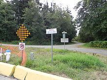
The only authorized land access to Canada from Point Roberts is Tyee Drive, a major thoroughfare northward that becomes 56th Street in Canada. Point Roberts also has a small airport (Point Roberts Airpark) and a large marina (Point Roberts Marina Resort) for air and water access; these two point facilities allow direct access to the rest of Washington state without the need to enter Canada.
Economy
Many of the area's businesses serve weekend and recreational visitors from Greater Vancouver. Canadians visit for cheaper American gasoline, alcohol, and food when the Canadian dollar is strong; Americans from Point Roberts do the same in Canada. Many Canadians visited its bars and nightclubs on Sundays until Sunday drinking was legalized in British Columbia in 1986. The local post office and several private companies rent many post office boxes to individuals and businesses from the Greater Vancouver area (including the U.S. Consulate in Vancouver), who find it a convenient and fast way to receive mail and parcels from the United States without paying for cross-border shipping costs.
Because of having to go through the international border twice to get to the rest of the U.S., some have called it "the best gated community in the U.S." Residents enjoy a low crime rate at the cost of a high local security presence and other inconveniences. There is no hospital, doctor, dentist, pharmacist, or veterinarian, and because American health insurers will not pay for treatment given by Canadian providers, Point Roberts residents usually seek emergency medical care in Bellingham, Washington, although Vancouver is closer. The international border also purportedly makes Point Roberts often used by the United States Federal Witness Protection Program.
Climate
Point Roberts lies within a depression created by Vancouver Island, the north shore mountains surrounding Vancouver, and the North Cascades (including Mount Baker). This micro-climate provides some of the mildest weather in the Pacific Northwest. With annual precipitation of about 1000 mm (40 inches), Point Roberts enjoys more sunny days and a milder climate than its neighbors.
Geology
Beneath Point Roberts, the bedrock of the Chuckanut Formation was deposited as an alluvial plain containing layers of sediments consisting of silt, sand, sand and gravel, and peat. During the last 60 million years the sediments were compacted and folded by mountain building forces resulting from continental drift to form strata of siltstone, sandstone, conglomerate and coal. During recent geologic history, the Chuckanut formation was overridden by four or more glaciations.
Point Roberts consists of a series of the resulting glacial sediments resting upon the Chuckanut Formation. The lowest glacial sediments (now near sea level) are from Salmon Springs or older glaciations. At the peak of the most recent glaciation, the main ice sheet was in excess of 7,000 feet thick as it moved southward between Vancouver Island and the Canadian Coast Range and down the Strait of Georgia. A smaller lobe of the continental glacier in excess of 5,000 feet traveled down the Fraser River flood plains merging with the main ice sheet over the greater Vancouver area and Whatcom and Skagit Counties. The coalesced continental ice sheet traveled south terminating in the vicinity of Chehalis, Washington. Relatively impermeable Vashon glacial lodgment till (estimated to be as much as 40 feet thick at the uppermost layer) was plastered over the advance outwash as the weight of the 7,000 foot thick plus Strait of Georgia ice lobe moved southward over approximately 10,000 years. (Armstrong, et. all, 1965) Point Roberts, Tsawwassen, and part of British Columbia extending past English Bluff actually comprised an island at the close of the Vashon Glaciation, approximately 11,000 years ago.
As the ice sheets melted, the thinner Fraser Lobe began to float while the Strait of Georgia lobe acted as a dam forming a lake under the Fraser Lobe. Sediments settling from the melting, floating ice resulted in the accumulation of 300 feet or more of Glacial Marine Drift over much of western Whatcom County. (Easterbrook, 1976; Geologic Map of Western Whatcom County, Washington, USGS, Map I-854-B) This Glacial Marine Drift is generally soft and was not consolidated by the weight of the glacier. A discontinuous, thin mantle of this Glacial Marine Drift above the Glacial Lodgment Till has been identified sporadically across Point Roberts. The uppermost layer of glacial sediments consists of recessional sand, silt, and gravel deposited as the Strait of Georgia ice lobe receded. Since the recession of the glaciers, the Fraser River has deposited deltaic sediments on the north and easterly side of the Point Roberts-Tsawwassen Island connecting it to the Greater Vancouver mainland (approximately 2,500 years ago, Murray 2008). At some locations, these sediments have been eroded or removed exposing the lodgment till.
Neighborhoods
Telecommunications
Until 1988, Point Roberts telephone numbers were in British Columbia's area code 604 and served by BCTel, the local telephone company for most of British Columbia. It was served by an exchange for Delta, resulting in the oddity of calls from British Columbia being local calls while calls from Washington and the rest of the United States were billed as international calls. In 1988, Point Roberts was shifted to area code 206, the area code for most of western Washington, using exchange 945—at the expense of losing the ability to make local calls to any other exchange in either country. Along with the rest of Whatcom County, Point Roberts moved to area code 360 in 1995. The local regular-service telecom provider is Whidbey Telecom.
Although Point Roberts is nominally part of the Seattle television market, the only over-the-air stations available in the town come from the Metro Vancouver region and Bellingham, Washington. Cable television in Point Roberts is provided by Delta Cable, a subsidiary of Canadian cable company EastLink. Delta Cable offers most major broadcast stations from Vancouver, and some stations from Seattle and Bellingham. Delta Cable also offers a selection of popular American cable networks, but no digital cable service or Canadian specialty channels, as they are not licensed to serve the United States.
Both Whidbey Telecom and Delta Cable provide broadband Internet access to residents of Point Roberts. Mobile telephone service is provided by a variety of companies, both American and Canadian.
Notable residents
Current
Past