
Highest elevation 13,803 ft (4,207.2 m) | ||
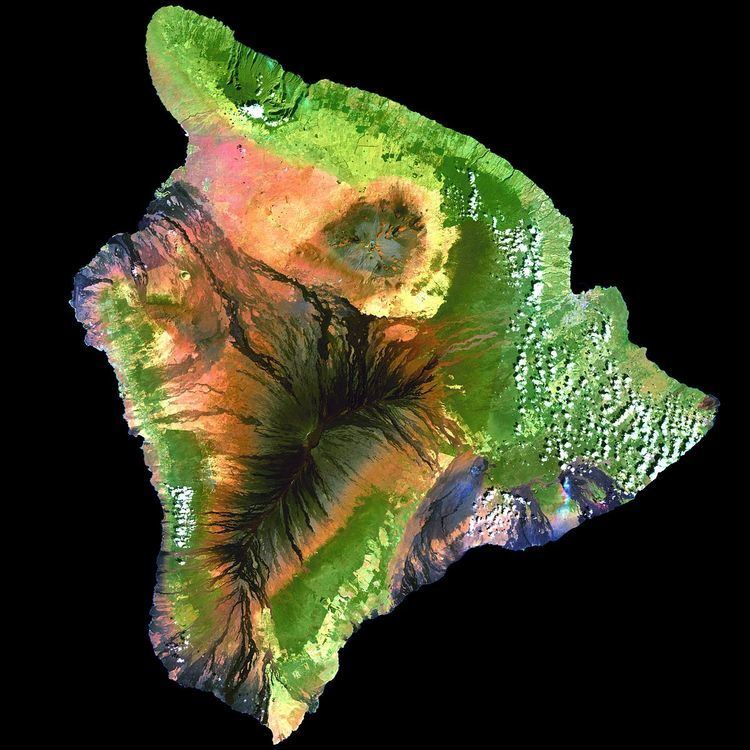 | ||
Area 4,028 sq mi (10,430 km) Area rank 1st, largest island in the United States | ||
Hawaiʻi ( /həˈwaɪ.i/ or /həˈwɑːiː/; [həˈvɐjʔi]) is the largest island located in the U.S. state of Hawaii. It is the largest and the southeastern-most of the Hawaiian Islands, a chain of volcanic islands in the North Pacific Ocean. With an area of 4,028 square miles (10,430 km2), it is larger than all of the other islands in the archipelago combined and is the largest island in the United States. However, it only has 13% of Hawaii's people. The island of Hawaii is the third largest island in Polynesia, behind the two main islands of New Zealand.
Contents
- Map of Island of Hawaii Hawaii USA
- HistoryEdit
- Geology and geographyEdit
- VolcanismEdit
- Great CrackEdit
- Hilina SlumpEdit
- Earthquakes and tsunamisEdit
- Volcanic fogEdit
- National protected areasEdit
- Adjacent countiesEdit
- DemographicsEdit
- County governmentEdit
- State governmentEdit
- EconomyEdit
- Top employersEdit
- EducationEdit
- RoadsEdit
- AirportsEdit
- SeaportsEdit
- Places of interestEdit
- CommunitiesEdit
- Unincorporated communitiesEdit
- References
Map of Island of Hawai'i, Hawaii, USA
The island is often referred to as the Island of Hawaiʻi, the Big Island, or Hawaiʻi Island to distinguish between the island and the state. Administratively, the whole island is encompassed by Hawaiʻi County.
As of the 2010 Census the population was 185,079. The county seat and largest city is Hilo. There are no incorporated cities in Hawaiʻi County (see Hawaii Counties).
HistoryEdit
Hawaiʻi is said to have been named after Hawaiʻiloa, the legendary Polynesian navigator who first discovered it. Other accounts attribute the name to the legendary realm of Hawaiki, a place from which the Polynesian people are said to have originated (see also Manua), the place where they go in the afterlife, the realm of the gods and goddesses. The name is cognate with Savaii, the name of the largest island of Samoa. Captain James Cook, the English explorer and navigator who was the captain of the first European expedition that discovered the Hawaiian Islands, called them the "Sandwich Islands" after his patron, the Earl of Sandwich. Cook was killed on the Big Island at Kealakekua Bay on 14 February 1779, in a mêlée which followed the theft of a ship's boat.
Hawaiʻi was the home island of Paiʻea Kamehameha, later known as Kamehameha the Great. Kamehameha united most of the Hawaiian islands under his rule in 1795, after several years of war, and gave the kingdom and the island chain the name of his native island.
Geology and geographyEdit
According to the U.S. Census Bureau, the county has a total area of 5,086 square miles (13,170 km2), of which 4,028 square miles (10,430 km2) is land and 1,058 square miles (2,740 km2) (20.8%) is water. The county's land area comprises 62.7 percent of the state's land area. It is the highest percentage by any county in the United States.
In greatest dimension, the island is 93 miles (150 km) across and has a land area of 4,028 square miles (10,430 km2) comprising 62% of the Hawaiian Islands' land area. Measured from its sea floor base to its highest peak, Mauna Kea is the world's tallest mountain, taller than Mount Everest is, since the base of Mount Everest is above sea level.
VolcanismEdit
The Island of Hawaiʻi is built from five separate shield volcanoes that erupted somewhat sequentially, one overlapping the other. These are (from oldest to youngest):
Geological evidence from exposures of old surfaces on the south and west flanks of Mauna Loa led to the proposal that two ancient volcanic shields (named Ninole and Kulani) were all but buried by the younger Mauna Loa. Geologists now consider these "outcrops" to be part of the earlier building of Mauna Loa. Another volcano which has already disappeared below the surface of the ocean is Māhukona.
Because Mauna Loa and Kīlauea are active volcanoes, the island of Hawaii is still growing. Between January 1983 and September 2002, lava flows added 543 acres (220 ha) to the island. Lava flowing from Kīlauea has destroyed several towns, including Kapoho in 1960, and Kalapana and Kaimu in 1990. In 1987 lava filled in Queen's Bath, a large, L-shaped, freshwater pool in the Kalapana area.
The southmost point in the 50 States of the United States, Ka Lae, is on Hawaii. The nearest landfall to the south is in the Line Islands. To the north of the Island of Hawaii is the Island of Maui, whose Haleakala volcano is visible from Hawaii across the Alenuihaha Channel.
Approximately 35 km (22 mi) southeast of Hawaii lies the undersea volcano known as Loihi. Loihi is an erupting seamount that now reaches approximately 3,200 feet (980 m) below the surface of the ocean. Continued activity at current rates from Loihi will likely cause it to break the surface of the ocean sometime from 10,000 to 100,000 years from now.
Great CrackEdit
The Great Crack is an eight-mile-long (13 km), 60-foot-wide (18 m) and 60-foot-deep (18 m) fissure in the island, in the district of Kau. According to the United States Geological Survey (USGS), The Great Crack is the result of crustal dilation from magmatic intrusions into the southwest rift zone of Kilauea. While neither the earthquake of 1868 nor that of 1975 caused a measurable change in The Great Crack, lava welled out of the lower 6.2 miles (10 km) of the Great Crack in 1823.
Visitors can find trails, rock walls, and archaeological sites from as old as the 12th century around the Great Crack. Approximately 1,951 acres (790 ha) of private land were purchased during the Presidency of Bill Clinton, specifically to protect various artifacts in this area, as well as the habitat of local wildlife.
Hilina SlumpEdit
The Hilina Slump is a 4,760-cubic-mile (19,800 km3) chunk of the south slope of the Kīlauea volcano which is slipping away from the island. Between 1990 and 1993, Global Positioning System (GPS) measurements showed a southward displacement of about 3.9 inches (10 cm) per year. Undersea measurements show that a "bench" has formed a buttress and that this buttress may tend to reduce the likelihood of future catastrophic detachment.
Earthquakes and tsunamisEdit
On 2 April 1868, an earthquake with a magnitude estimated between 7.25 and 7.9 on the Richter scale rocked the southeast coast of Hawaii. This was the most destructive earthquake in the recorded history of Hawaii. It triggered a landslide on Mauna Loa, five miles (8.0 km) north of Pahala, killing 31 people. A tsunami claimed 46 more lives. The villages of Punaluu, Ninole, Kawaa, Honuapo, and Keauhou Landing were severely damaged. The tsunami reportedly rolled over the tops of the coconut trees up to 60 feet (18 m) high, and it reached inland a distance of a quarter of a mile (400 meters) in some places.
On 29 November 1975, a 37-mile-wide (60 km) section of the Hilina Slump dropped 11.5 feet (3.5 m) and slid 26 feet (7.9 m) toward the ocean. This movement caused a 7.2 magnitude earthquake and a 48-foot-high (15 m) tsunami. Oceanfront property was washed off its foundations in Punaluu. Two deaths were reported at Halape, and 19 other people were injured.
The island suffered tsunami damage from earthquakes in Alaska on 1 April 1946, and in Chile on 23 May 1960. Downtown Hilo was severely damaged by both tsunamis, with many lives lost. Just north of Hilo, Laupahoehoe lost 16 schoolchildren and five teachers in the tsunami of 1946.
In March 2011, a 9.0 magnitude earthquake off the east coast of Japan again created a tsunami that caused minor damage in Hawaii. The estimated damage to public buildings alone was about US$3 million. In the Kona area this tsunami washed a house into Kealakekua Bay, destroyed a yacht club and tour boat offices in Keauhou Bay, caused extensive damage in Kailua Kona, flooded the ground floor of the King Kamehameha Hotel, and permanently closed the Kona Village Resort.
Volcanic fogEdit
Vog (volcanic fog) can envelop the island. The gas plumes of the Kīlauea Volcano create a blanket of vog which the dominant trade winds mostly deflect toward the Kona coast on the west side of the Island of Hawaiʻi. Vog contains chemicals that can damage the environment, and the health of plants, humans, and other animals. Most of the aerosols are acidic and of a size where they can remain in the lungs to damage the lungs and impair function. Flu-like symptoms and general lethargy are reported, especially pronounced in people with respiratory conditions.
National protected areasEdit
Adjacent countiesEdit
DemographicsEdit
As of the census of 2010, the island had a resident population of 185,079. There were 64,382 households in the county. The population density was 17.7/km2 (45.9/mi2). There were 82,324 housing units at an average density of 8/km2 (20/mi2). The racial makeup of the county was 34.5% White, 0.7% African American, 22.6% Asian, 12.4% Native Hawaiian or other Pacific Islander, and 29.2% from two or more races; 11.8% of the population were Hispanics or Latinos of any race.
There were 64,382 households out of which 32.20% had children under the age of 18 living with them, 50.60% were married couples living together, 13.20% had a woman whose husband did not live with her, and 30.40% were non-families. 23.10% of all households were made up of individuals and 8.00% had someone living alone who was 65 years of age or older. The average household size was 2.75 and the average family size was 3.24.
The age distribution was 26.10% under 18, 8.20% from 18 to 24, 26.20% from 25 to 44, 26.00% from 45 to 64, and 13.50% who were 65 or older. The median age was 39 years. For every 100 females there were 100 males. For every 100 females age 18 and over, there were 98 males.
41.31% of the people in Hawaii, Hawaii are religious, meaning they affiliate with a religion. 18.38% are Catholic; 3.70% are another Christian faith; 5.14% are LDS; 0.06% in Hawaii, Hawaii are Jewish; 5.04% are an eastern faith; 0.05% affilitates with Islam.
County governmentEdit
Hawaii County, Hawaii, encompasses the entire island of Hawaii. Executive authority is vested in the Mayor of Hawaii County who is elected for a four-year term. Since 2004, the election by the voters has been on a non-partisan basis. In 2008, Billy Kenoi was elected Mayor, succeeding Harry Kim who had served a two-term limit. Legislative authority is vested in a nine-member County Council. Each member represents a geographical region of the island, which closely correlates to one of the nine tax map districts of Hawaiʻi County. Members of the County Council are elected on a non-partisan basis to two-year terms, with the latest election occurring in November 2010.
Administrative districts were originally based on the traditional land divisions called Moku of Ancient Hawaii. Some of the more heavily populated districts have since been split into North and South districts to make them more comparable on a population basis.
The number following each district is the Tax Map Key (TMK) number, used to locate state property information. They are assigned in a counter-clockwise order beginning on the eastern side of the island.
County council districts do not directly match the property tax districts because of the variation in the population density of voters in urban areas to rural areas; Hilo & Kailua (Kailua-Kona) towns are densely populated areas, while other districts such as Kaʻū, Puna, Hāmakua, and North & South Kohala are more sparsely populated.
Several government functions are administered at the county level that are at the state or municipal level in other states. For example, the county has its own office of liquor control.
State governmentEdit
Hawaii Department of Public Safety previously operated the Kulani Correctional Facility in Hawaii County, on the Island of Hawaii. In 2009, the Hawaii Department of Public Safety announced that Kulani Correctional Facility would close.
EconomyEdit
Sugarcane was the backbone of Hawaiʻi Island's economy for more than a century. In the mid-20th century, sugarcane plantations began to downsize and in 1996, the last plantation closed.
Most of Hawaiʻi Island's economy is based on tourism, centered primarily in resort areas on the western coast of the island in the North Kona and South Kohala districts. More recently, Hawaiʻi Island has become a focus for sustainable tourism.
Diversified agriculture is a growing sector of the economy. Major crops include Macadamia nuts, papaya, flowers, tropical and temperate vegetables, and coffee beans. Only coffee grown in the Kona District of this island may be branded Kona coffee. The island's orchid agriculture is the largest in the state, and resulted in the unofficial nickname "The Orchid Isle." The island is home to one of the United States' largest cattle ranches: Parker Ranch, on 175,000 acres (708 km2) in Waimea. Hawaiʻi is also known for astronomy, and numerous telescopes are operated on the summit of Mauna Kea, where atmospheric clarity is excellent and there is little light pollution.
NELHA (Natural Energy Laboratory of Hawaii Authority), a 675-acre state developed site, is a green economic development ocean science and technology park on the west side of the Hawaii island. It provides resources and facilities for energy and ocean-related research, education, and commercial activities in an environmentally sound and culturally sensitive manner. Business tenants on this coastal site include microalgae farms, aquaculture, solar technology and marine biotech. Tenants have access to three sets of pipelines delivering deep sea water from a depth of up to 3000 feet, as well as pristine sea surface water and almost constant sunshine. NELHA is a success story for the State of Hawaii and the Big Island. A 2012 study by the University of Hawaii Economic Research Organization (UHERO) found the total economic impact of activities at NELHA was $87.7 million and created 583 jobs.
Top employersEdit
According to the County's 2010 Comprehensive Annual Financial Report, the top employers in the county are:
EducationEdit
RoadsEdit
Three routes connect the two major towns, Hilo on the east coast and Kailua-Kona on the west coast of the island:
There are also State highways 270 (Kawaihae – Hawi) and 180 (the "Kona coffee road", from Honalo to State highway 190), South Point Road (Highway 11 to South Point), etc.
There are presently three Hawaii Scenic Byways on the island of Hawaii:
Rental car offices are at the international airports. Taxi service is also available. Island-wide bus service is provided by the "Hele-On Bus".
AirportsEdit
Two commercial airports serve Hawaiʻi Island:
There is also:
SeaportsEdit
Major commercial ports are Hilo on the East side and Kawaihae on the West side of the island. Cruise ships often stop at Kailua-Kona (90 times in 2017) and Hilo (108 times in 2017).
Places of interestEdit
CommunitiesEdit
The island was traditionally divided into districts called moku. The names of the districts are (counter-clockwise, from the southeast): Puna, Hilo, Hāmākua, Kohala, Kona, and Kaʻū. The county government subdivides some of these to form elective districts of the county council. There are no incorporated municipalities on the island.