
Length 4,700 km | Basin area 4.014 million km² | |
 | ||
- average 41,000 m/s (1,447,901 cu ft/s) - max 75,000 m/s (2,648,600 cu ft/s) - min 23,000 m/s (812,237 cu ft/s) Similar | ||
The Congo River (also known as the Zaire River; French: (le) fleuve Congo/Zaïre; Portuguese: rio Congo/Zaire; Kongo: Nzâdi Kôngo) is a river in Africa. It is the second largest river in the world by discharge (after the Amazon), and the world's deepest river with measured depths in excess of 220 m (720 ft). The Congo-Chambeshi river has an overall length of 4,700 km (2,920 mi), which makes it the ninth-longest river (in terms of discharge, the Chambeshi is a tributary of the Lualaba River, Lualaba being the name of the Congo River upstream of the Boyoma Falls, extending for 1,800 km). Measured along the Lualaba, the Congo River has a total length of 4,370 km (2,715 mi). It crosses the equator twice. The Congo Basin has a total area of about 4 million km2, or 13% of the entire African landmass.
Contents
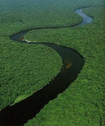
- Map of Congo River
- Name
- Basin and course
- Tributaries
- Economic importance
- Hydro electric power
- Natural history
- Exploration
- References
Map of Congo River
Name
The name River Congo originated from the Kingdom of Kongo which was located on the southern bank of the river. The kingdom in turn is named for the Bantu population, in the 17th century reported as Esikongo. South of the Kongo kingdom proper lay the similarly named Kakongo kingdom, mentioned in 1535. Abraham Ortelius in his world map of 1564 labels as Manicongo the city at the mouth of the river. The tribal names in kongo possibly derive from a word for a public gathering or tribal assembly. Little is known about the peoples of the inner Congo, but "It is probable that the word 'Kongo' itself implies a public gathering and that it is based on the root konga, 'to gather' (trans[itive])." "The usual interpretations, admittedly unsatisfactory (Laman, 1953, p. 10), make the mistake of being too concrete; for example, they may claim that "Kongo" comes from n'kongo ('hunter')". The modern name of the Kongo people or Bakongo was introduced in the early 20th century.
The name Zaire is from a Portuguese adaptation of a Kikongo word nzere ("river"), a truncation of nzadi o nzere ("river swallowing rivers"). The river was known as Zaire during the 16th and 17th centuries; Congo seems to have replaced Zaire gradually in English usage during the 18th century, and Congo is the preferred English name in 19th-century literature, although references to Zahir or Zaire as the name used by the natives (i.e. derived from Portuguese usage) remained common.
The Democratic Republic of the Congo and the Republic of the Congo are named after it, as was the previous Republic of the Congo which had gained independence in 1960 from the Belgian Congo.
The state of Zaire during 1971–1997 was also named after the river, after its name in French and Portuguese.
Basin and course
The Congo's drainage basin covers 4,014,500 square kilometres (1,550,000 sq mi). The Congo's discharge at its mouth ranges from 23,000 to 75,000 cubic metres per second (810,000 to 2,650,000 cu ft/s), with an average of 41,000 cubic metres per second (1,400,000 cu ft/s).
The river and its tributaries flow through the Congo Rainforest, the second largest rain forest area in the world, second only to the Amazon Rainforest in South America. The river also has the second-largest flow in the world, behind the Amazon; the third-largest drainage basin of any river, behind the Amazon and Plate rivers; and is one of the deepest rivers in the world, at depths greater than 220 m (720 ft). Because its drainage basin includes areas both north and south of the equator, its flow is stable, as there is always at least one part of the river experiencing a rainy season.
The sources of the Congo are in the highlands and mountains of the East African Rift, as well as Lake Tanganyika and Lake Mweru, which feed the Lualaba River, which then becomes the Congo below Boyoma Falls. The Chambeshi River in Zambia is generally taken as the source of the Congo in line with the accepted practice worldwide of using the longest tributary, as with the Nile River.
The Congo flows generally toward the northwest from Kisangani just below the Boyoma falls, then gradually bends southwestwards, passing by Mbandaka, joining with the Ubangi River, and running into the Pool Malebo (Stanley Pool). Kinshasa (formerly Léopoldville) and Brazzaville are on opposite sides of the river at the Pool, where the river narrows and falls through a number of cataracts in deep canyons (collectively known as the Livingstone Falls), running by Matadi and Boma, and into the sea at the small town of Muanda.
The Congo River Basin is one of the distinct physiographic sections of the larger Mid-African province, which in turn is part of the larger African massive physiographic division.
Tributaries
Sorted in order from the mouth heading upstream.
Downstream of Kinshasa, there are no important tributaries.
Upstream of Boyoma Falls near Kisangani, the river Congo is known as the Lualaba River.
Economic importance
Although the Livingstone Falls prevent access from the sea, nearly the entire Congo above them is readily navigable in sections, especially between Kinshasa and Kisangani. Large river steamers worked the river until quite recently. The Congo River still is a lifeline in a land with few roads or railways.
Railways now bypass the three major falls, and much of the trade of Central Africa passes along the river, including copper, palm oil (as kernels), sugar, coffee, and cotton. The river is also potentially valuable for hydroelectric power, and the Inga Dams below Pool Malebo are first to exploit the Congo river.
Hydro-electric power
The Congo River is the most powerful river in Africa. During the rainy season over 50,000 cubic metres (1,800,000 cu ft) of water per second flow into the Atlantic Ocean. Opportunities for the Congo River and its tributaries to generate hydropower are therefore enormous. Scientists have calculated that the entire Congo Basin accounts for 13 percent of global hydropower potential. This would provide sufficient power for all of sub-Saharan Africa's electricity needs.
Currently there are about forty hydropower plants in the Congo Basin. The largest is the Inga Falls dam, about 200 kilometres (120 mi) southwest of Kinshasa. The project was launched in the early 1970s, when the first dam was completed. The plan as originally conceived called for the construction of five dams that would have had a total generating capacity of 34,500 megawatts. To date only two dams have been built, which are the Inga I and Inga II, with a total of fourteen turbines.
In February 2005, South Africa's state-owned power company, Eskom, announced a proposal to increase the capacity of the Inga dramatically through improvements and the construction of a new hydroelectric dam. The project would bring the maximum output of the facility to 40 gigawatts (54,000,000 hp), twice that of China's Three Gorges Dam.
It is feared that these new hydroelectric dams could lead to the extinction of many of the fish species that are endemic to the river.
Natural history
The current course of the Congo River formed 1.5–2 million years BP, during the Pleistocene.
The Congo's formation may have led to the allopatric speciation of the bonobo and the common chimpanzee from their most recent common ancestor. The bonobo is endemic to the humid forests in the region, as are other iconic species like the Allen's swamp monkey, dryas monkey, aquatic genet, okapi and Congo peafowl.
In terms of aquatic life, the Congo River Basin has a very high species richness, and among the highest known concentrations of endemics. Until now, almost 700 fish species have been recorded from the Congo River Basin, and large sections remain virtually unstudied. Due to this and the great ecological differences between the regions in the basin, it is often divided into multiple ecoregions (instead of treating it as a single ecoregion). Among these ecoregions, the Lower Congo Rapids alone has more than 300 fish species, including approximately 80 endemics while the southwestern part (Kasai Basin) alone has more than 200 fish species, of which about a quarter are endemic. The dominant fish families – at least in parts of the river – are Cyprinidae (carp/cyprinids, such as Labeo simpsoni), Mormyridae (elephantfishes), Alestidae (African tetras), Mochokidae (squeaker catfishes), and Cichlidae (cichlids). Among the natives in the river is the huge, highly carnivorous giant tigerfish. Two of the more unusual endemic cichlids are the whitish (non-pigmented) and blind Lamprologus lethops, which is believed to live as deep as 160 metres (520 ft) below the surface, and Heterochromis multidens, which appears to be more closely related to cichlids of the Americas than other Africa cichlid. There are also numerous endemic frogs and snails. Several hydroelectric dams are planned on the river, and these may lead to the extinction of many of the endemics.
Several species of turtles, and the slender-snouted, Nile and dwarf crocodile are native to the Congo River Basin. African manatees inhabit the lower parts of the river.
Exploration
The entire Congo basin is populated by Bantu peoples, divided into several hundred ethnic or tribal groups (see ethnic groups of the Democratic Republic of the Congo). Bantu expansion is estimated to have reached the Middle Congo by about 500 BC, and the Upper Congo by the time of Christ. Remnants of the aboriginal population displaced by the Bantu migration, Pygmies/Abatwa of the Ubangian phylum, remain in the remote forest areas of the Congo basin.
The Kingdom of Kongo was formed around 1400 on the left banks of the lower Congo River. Its territorial control along the river remained limited to what corresponds to the modern Bas-Congo province. European exploration of the Congo begins in 1482, when Portuguese explorer Diogo Cão discovered the river estuary (likely in August 1482), which he marked by a Padrão, or stone pillar (still existing, but only in fragments) erected on Shark Point. Cão also sailed up the river for a short distance, establishing contact with the Kingdom of Congo. The full course of the river remained unknown throughout the early modern period.
The upper Congo basin runs west of the Albertine Rift. Its connection to the Congo was unknown until 1877. The extreme northeast of the Congo basin was reached by the Nilotic expansion at some point between the 15th and 18th centuries, by the ancestors of the Southern Luo speaking Alur people. Francisco de Lacerda following the Zambezi reached the uppermost part of the Congo basin (the Kazembe in the upper Luapula basin) in 1796.
The upper Congo River, known as the Lualaba was first reached by the Arab slave trade by the 19th century. Nyangwe was founded as a slavers' outpost around 1860. David Livingstone was the first European to reach Nyangwe in March 1871. Livingstone proposed to prove that the Lualaba connected to the Nile, but on 15 July, he witnessed a massacre of about 400 Africans by Arab slavers in Nyangwe, which experience left him too horrified and shattered to continue his mission to find the sources of the Nile, so he turned back to Lake Tanganyika.
The middle reaches of the Congo remained unexplored from either the east or west, until Henry Morton Stanley's expedition of 1876–77. At the time one of the last open questions of the exploration of Africa (or indeed of the world) whether the Lualaba River fed the Nile (Livingstone's theory), the Congo or even the Niger. Financed in 1874, Stanley's first trans-Africa exploration started in Zanzibar, and reached the Lualaba on October 17, 1876. Overland he reached Nyangwe, the centre of a lawless area containing cannibal tribes at which Tippu Tip based his trade in slaves. Stanley managed to hire a force from Tippu Tip, to guard him for the next 150 kilometres (90 mi) or so, for 90 days. The party left Nyangwe overland through the dense Matimba forest. On November 19 they reached the Lualaba again. Since the going through the forest was so heavy, Tippu Tip turned around with his party on December 28, leaving Stanley on his own, with 143 people, including 8 children and 16 women. They had 23 canoes. His first encounter with a local tribe was with the cannibal Wenya. In total Stanley would report 32 unfriendly meetings on the river, some violent, even though he attempted to negotiate a peaceful thoroughfare. But the tribes were wary as their only experience of outsiders was of slave traders, and they could not understand his motive of exploration.
On January 6, 1877, after 640 kilometres (400 mi), they reached Boyoma Falls (called Stanley Falls for some time after), consisting of seven cataracts spanning 100 kilometres (60 mi) which they had to bypass overland. It took them to February 7 to reach the end of the falls. Here Stanley learned that the river was called Ikuta Yacongo, proving to him that he had reached the Congo, and that the Lualaba did not feed the Nile.
From this point, the tribes were no longer cannibals, but possessed firearms, apparently as a result of Portuguese influence. Some four weeks and 1,900 kilometres (1,200 mi) later he reached Stanley Pool (now Pool Malebo), the site of the present day cities Kinshasa and Brazzaville. Further downstream were the Livingstone Falls, misnamed as Livingstone had never been on the Congo: a series of 32 falls and rapids with a fall of 270 metres (900 ft) over 350 kilometres (220 mi). On 15 March they started the descent of the falls, which took five months and cost numerous lives. From the Isangile Falls, five falls from the foot, they beached the canoes and Lady Alice and left the river, aiming for the Portuguese outpost of Boma via land. On August 3 they reached the hamlet Nsada. From there Stanley sent four men with letters forward to Boma, asking for food for his starving people. On August 7 relief came, being sent by representatives from the Liverpool trading firm Hatton & Cookson. On August 9 they reached Boma, 1,001 days since leaving Zanzibar on November 12, 1874. The party then consisted of 108 people, including three children born during the trip. Most probably (Stanley's own publications give inconsistent figures), he lost 132 people through disease, hunger, drowning, killing and desertion.
Kinshasa was founded as a trading post by Stanley in 1881 and named Léopoldville in honour of Leopold II of Belgium. The Congo basin was claimed by Belgium as Congo Free State in 1885.