
Created 1980 Electors 101,914 (2016) Founded 1980 Elector 101,914 | Demographic Rural Namesake C. Y. O'Connor | |
 | ||
Area 868,576 km (335,359.1 sq mi) Party Liberal Party of Australia | ||
The Division of O'Connor is an Australian electoral division in the state of Western Australia. It is one of Western Australia's three rural seats, and one of the largest electoral constituencies in the world.
The Division was named after C. Y. O'Connor, the Engineer-in-Chief of Western Australia who designed Fremantle Harbour and the Goldfields Pipeline. The Division was proclaimed at the redistribution of 28 February 1980, and was first contested at the 1980 federal election.
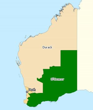
It has always been a rural seat, and was historically based in the Mid West, Wheatbelt and Great Southern regions of Western Australia with major population centres in Geraldton and Albany. The Division was significantly altered by a redistribution in 2008, taking effect at the 2010 election. The other large country seat in Western Australia, Kalgoorlie, needed to expand in size, but it proved all but impossible to reconfigure Kalgoorlie in a way that would have left O'Connor with any rational basis. Ultimately, it was decided to abolish Kalgoorlie and push O'Connor well to the east to take in most of Kalgoorlie's former southern portion. The northern portion of the old O'Connor was shifted to the new seat of Durack.
It is now centred on the Great Southern and Goldfields-Esperance regions of the state (while incorporating the southern Wheatbelt), with major population centres in Albany, Kalgoorlie and Esperance. Local government areas within the electorate include Albany, Boyup Brook, Bridgetown-Greenbushes, Brookton, Broomehill-Tambellup, Bruce Rock, Coolgardie, Corrigin, Cranbrook, Cuballing, Denmark, Dumbleyung, Dundas, Esperance, Gnowangerup, Jerramungup, Kalgoorlie-Boulder, Katanning, Kent, Kojonup, Kondinin, Kulin, Lake Grace, Laverton, Leonora, Manjimup, Menzies, Narembeen, Narrogin, Ngaanyatjarraku, Pingelly, Plantagenet, Quairading, Ravensthorpe, Wagin, Wandering, West Arthur, Westonia, Wickepin, Williams, Woodanilling, and Yilgarn.
The seat has always been held by a conservative party. When it was created, its demographics suggested that it should have been held by the National Country Party, despite its large notional Liberal majority. However, severe infighting between the national and state Country parties allowed Liberal Wilson Tuckey to take the seat on Labor preferences. Tuckey held it without serious difficulty until his defeat at the 2010 election by Nationals WA candidate Tony Crook with a large swing. However, the Liberals regained the seat at the 2013 election.