Population 996 (2013 est) Founded 1913 Mayor Stephen Strange Federal division Division of O'Connor | Established 1913 Area 2,727 km² | |
 | ||
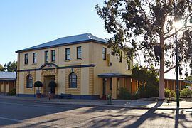
The Shire of Bruce Rock is a local government area in the Wheatbelt region of Western Australia, about 50 kilometres (31 mi) south of Merredin and about 250 kilometres (155 mi) east of the state capital, Perth. The Shire covers an area of 2,727 square kilometres (1,053 sq mi), and its seat of government is the town of Bruce Rock.
Contents
History
Bruce Rock was initially constituted as the East Avon Road District in 1913. In 1918, it was renamed to Bruce Rock, and on 1 July 1961, it became a shire following the enactment of the Local Government Act 1960. In 1999, the Ardath, Babakin, Kwolyin, Shackleton, Belka and Coordarin wards covering outlying areas of the Shire were replaced by 2-member South, West and East Wards, while the Central and Town wards covered other areas. Wards were abolished for the 2005 elections.
Wards
The Shire is no longer divided into wards and the eleven councillors represent the entire Shire.
