
- elevation 3,060 ft (933 m) Length 486 km Basin area 38,073 km² Cities Harpers Ferry | - elevation 0 ft (0 m) Discharge 306 m³/s | |
 | ||
- average 11,600 cu ft/s (328 m/s) Sources Appalachian Mountains, Fairfax Stone Historical Monument State Park | ||
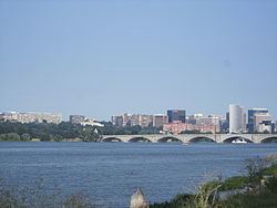
Potomac river upstream from washington dc real usa ep 129
The Potomac River /pəˈtoʊmək/ ( listen ) is located along the mid-Atlantic Ocean coast of the United States and flows into the Chesapeake Bay. The river (main stem and North Branch) is approximately 405 miles (652 km) long, with a drainage area of about 14,700 square miles (38,000 km2). In terms of area, this makes the Potomac River the fourth largest river along the Atlantic coast of the United States and the 21st largest in the United States. Over 5 million people live within the Potomac watershed.
Contents
- Potomac river upstream from washington dc real usa ep 129
- Map of Potomac River United States
- Whitewater tubing thrills on the potomac river in maryland with river trail outfitters
- GeographyEdit
- HistoryEdit
- Water supply and water qualityEdit
- Legal issuesEdit
- North Branch Potomac RiverEdit
- South Branch Potomac RiverEdit
- South Branch nomenclatureEdit
- South Branch headwaters and courseEdit
- South Branch tributariesEdit
- North Fork South Branch Potomac RiverEdit
- South Fork South Branch Potomac RiverEdit
- Upper Potomac RiverEdit
- Upper Potomac tributariesEdit
- Tidal Potomac RiverEdit
- Tidal Potomac tributariesEdit
- FishEdit
- References
Map of Potomac River, United States
Whitewater tubing thrills on the potomac river in maryland with river trail outfitters
GeographyEdit
The river forms part of the borders between Maryland and Washington, D.C., on the left descending bank and West Virginia and Virginia on the river's right descending bank. The majority of the lower Potomac River is part of the State of Maryland. Exceptions include a small tidal portion within the District of Columbia, and the border with Virginia being delineated from "point to point" (thus various bays and shoreline indentations lie in Virginia). Except for a small portion of its headwaters in West Virginia, the North Branch Potomac River is considered part of Maryland to the low water mark on the opposite bank. The South Branch Potomac River lies completely within the state of West Virginia except for its headwaters, which lie in Virginia.
The Potomac River runs 405 miles (652 km) from the Fairfax Stone in West Virginia on the Allegheny Plateau to Point Lookout, Maryland, and drains 14,679 square miles (38,020 km2). The length of the river from the junction of its North and South Branches to Point Lookout is 302 miles (486 km). The average flow is 10,800 ft³/s (306 m³/s). The largest flow ever recorded on the Potomac at Washington, D.C., was in March 1936 when it reached 425,000 ft³/s (12,000 m³/s). The lowest flow ever recorded at the same location was 600 ft³/s (17 m³/s) in September, 1966.
The river has two sources. The source of the North Branch is at the Fairfax Stone located at the junction of Grant, Tucker, and Preston counties in West Virginia. The source of the South Branch is located near Hightown in northern Highland County, Virginia. The river's two branches converge just east of Green Spring in Hampshire County, West Virginia, to form the Potomac.
Once the Potomac drops from the Piedmont to the Coastal Plain at Little Falls, tides further influence the river as it passes through Washington, D.C. and beyond. Salinity in the Potomac River Estuary increases thereafter with distance downstream. The estuary also widens, reaching 11 statute miles (17 km) wide at its mouth, between Point Lookout, Maryland, and Smith Point, Virginia, before flowing into the Chesapeake Bay.
HistoryEdit
"Potomac" is a European spelling of Patowmeck, the Algonquian name of a Native American village, perhaps meaning "something brought". Native Americans had different names for different parts of the river, calling the river above Great Falls Cohongarooton, meaning "honking geese" and "Patawomke" below the fall, meaning "river of swans". The spelling of the name has taken many forms over the years from "Patawomeke" (as on Captain John Smith's map) to "Patawomeck", "Patowmack", and numerous other spellings in the 18th century and now "Potomac". The river's name was officially decided upon as Potomac by the Board on Geographic Names in 1931.
The river itself is at least two million years old, likely extending back ten to twenty million years before present when the Atlantic Ocean lowered and exposed coastal sediments along the fall line. This included the area at Great Falls, which eroded into its present form during recent glaciation periods.
The Potomac River brings together a variety of cultures throughout the watershed from the coal miners of upstream West Virginia to the urban residents of the nation's capital and, along the lower Potomac, the watermen of Virginia's Northern Neck.
Being situated in an area rich in American history and American heritage has led to the Potomac being nicknamed "the Nation's River." George Washington, the first President of the United States, was born in, surveyed, and spent most of his life within the Potomac basin. All of Washington, D.C., the nation's capital city, also lies within the watershed. The 1859 siege of Harper's Ferry at the river's confluence with the Shenandoah was a precursor to numerous epic battles of the American Civil War in and around the Potomac and its tributaries, such as the 1861 Battle of Ball's Bluff and the 1862 Battle of Shepherdstown. General Robert E. Lee crossed the river, thereby invading the North and threatening Washington, D.C., twice in campaigns climaxing in the battles of Antietam (September 17, 1862) and Gettysburg (July 1–3, 1863). Confederate General Jubal Early crossed the river in July 1864 on his attempted raid on the nation's capital. The river not only divided the Union from the Confederacy, but also gave name to the Union's largest army, the Army of the Potomac.
The Patowmack Canal was intended by George Washington to connect the Tidewater region near Georgetown with Cumberland, Maryland. Started in 1785 on the Virginia side of the river, it was not completed until 1802. Financial troubles led to the closure of the canal in 1830. The Chesapeake and Ohio Canal operated along the banks of the Potomac in Maryland from 1831 to 1924 and also connected Cumberland to Washington, D.C. This allowed freight to be transported around the rapids known as the Great Falls of the Potomac River, as well as many other, smaller rapids.
Washington, D.C. began using the Potomac as its principal source of drinking water with the opening of the Washington Aqueduct in 1864, using a water intake constructed at Great Falls.
In March 1996 an agreement was signed which made the Potomac a "sister river" of the Ara River, one of the principal rivers of Tokyo. President Bill Clinton designated the Potomac as one of the American Heritage Rivers in 1998.
Water supply and water qualityEdit
An average of approximately 486 million US gallons (1,840,000 m3) of water per day is withdrawn daily in the Washington area for water supply.
As a result of damaging floods in 1936 and 1937, the Army Corps of Engineers proposed a series of dams that were intended to regulate the river and to provide a more reliable water supply. One dam was to be built at Little Falls, just north of Washington, backing its pool up to Great Falls. Just above Great Falls, a much larger dam was proposed whose reservoir would extend to Harpers Ferry. Several other dams were proposed for the Potomac and its tributaries. When detailed studies were issued by the Corps in the 1950s, they met sustained opposition, led by U.S. Supreme Court Justice William O. Douglas, resulting in the plans' abandonment. The only dam project that did get built was Jennings Randolph Lake on the North Branch. The Corps built a supplementary water intake for the Washington Aqueduct at Little Falls in 1959.
In 1940 Congress passed a law authorizing creation of an interstate compact to coordinate water quality management among states in the Potomac basin. Maryland, West Virginia, Pennsylvania, Virginia, and the District of Columbia agreed to establish the Interstate Commission on the Potomac River Basin. The compact was amended in 1970 to include coordination of water supply issues and land use issues related to water quality.
Beginning in the 19th century, with increasing mining and agriculture upstream and urban sewage and runoff downstream, the water quality of the Potomac River deteriorated. This created conditions of severe eutrophication. It is said that President Abraham Lincoln used to escape to the highlands on summer nights to escape the river's stench. In the 1960s, with dense green algal blooms covering the river's surface, President Lyndon Johnson declared the river "a national disgrace" and set in motion a long-term effort to reduce pollution from sewage and restore the beauty and ecology of this historic river. One of significant pollution control projects at the time was the expansion of the Blue Plains Advanced Wastewater Treatment Plant, which serves Washington and several surrounding communities. Enactment of the 1972 Clean Water Act led to construction or expansion of additional sewage treatment plants in the Potomac watershed. Controls on phosphorus, one of the principal contributors to eutrophication, were implemented in the 1980s, through sewage plant upgrades and restrictions on phosphorus in detergents.
By the end of the 20th century, there was notable success, as massive algal blooms vanished and recreational fishing and boating rebounded. Still, the aquatic habitat of the Potomac River and its tributaries remain vulnerable to eutrophication, heavy metals, pesticides and other toxic chemicals, over-fishing, alien species, and pathogens associated with fecal coliform bacteria and shellfish diseases. In 2005 two federal agencies, the US Geological Survey and the Fish and Wildlife Service, began to identify fish in the Potomac and tributaries that exhibited "intersex" characteristics, as a result of endocrine disruption caused by some form of pollution. On November 13, 2007, the Potomac Conservancy, an environmental group, issued the river a grade of "D-plus", citing high levels of pollution and the reports of "intersex" fish. Since then, the river has improved with a reduction in nutrient runoff, return of fish populations and land protection along the river. As a result, the same group issued a grade of "B-minus" in 2016.
Legal issuesEdit
For 400 years Maryland and Virginia have disputed control of the Potomac and its North Branch, since both states' original colonial charters grant the entire river rather than half of it as is normally the case with boundary rivers. In its first state constitution adopted in 1776, Virginia ceded its claim to the entire river but reserved free use of it, an act disputed by Maryland. Both states acceded to the Compact of 1785 and the 1877 Black-Jenkins Award which grants Maryland the river bank-to-bank from the low water mark on the Virginia side, while permitting Virginia full riparian rights short of obstructing navigation.
From 1957 to 1996, the Maryland Department of the Environment (MDE) routinely issued permits applied for by Virginia entities concerning use of the Potomac. However, in 1996 the MDE denied a permit submitted by the Fairfax County Water Authority to build a water intake 725 feet (220 m) offshore, citing potential harm to Maryland's interests by an increase in Virginia sprawl caused by the project. After years of failed appeals within the Maryland government's appeal processes, in 2000 Virginia took the case to the Supreme Court of the United States, which exercises original jurisdiction in cases between two states. Maryland claimed Virginia lost its riparian rights by acquiescing to MDE's permit process for 63 years (MDE began its permit process in 1933). A Special Master appointed by the Supreme Court to investigate recommended the case be settled in favor of Virginia, citing the language in the 1785 Compact and the 1877 Award. On December 9, 2003, the Court agreed in a 7-2 decision.
The original charters are silent as to which branch from the upper Potomac serves as the boundary, but this was settled by the 1785 Compact. When West Virginia seceded from Virginia in 1863, the question of West Virginia's succession in title to the lands between the branches of the river was raised, as well as title to the river itself. Claims by Maryland to West Virginia land north of the South Branch (all of Mineral and Grant Counties and parts of Hampshire, Hardy, Tucker and Pendleton Counties) and by West Virginia to the Potomac's high-water mark were rejected by the Supreme Court in two separate decisions in 1910.
North Branch Potomac RiverEdit
The source of the North Branch Potomac River is at the Fairfax Stone located at the junction of Grant, Tucker and Preston counties in West Virginia.
From the Fairfax Stone, the North Branch Potomac River flows 27 miles (43 km) to the man-made Jennings Randolph Lake, an impoundment designed for flood control and emergency water supply. Below the dam, the North Branch cuts a serpentine path through the eastern Allegheny Mountains. First, it flows northeast by the communities of Bloomington, Luke, and Westernport in Maryland and then on by Keyser, West Virginia to Cumberland, Maryland. At Cumberland, the river turns southeast. 103 miles (166 km) downstream from its source, the North Branch is joined by the South Branch between Green Spring and South Branch Depot, West Virginia from whence it flows past Hancock, Maryland and turns southeast once more on its way toward Washington, D.C., and the Chesapeake Bay.
The following are major tributaries of the North Branch Potomac River, listed in order from the source to its mouth. Numerous other tributary creeks exist.
South Branch Potomac RiverEdit
The South Branch Potomac River has its headwaters in northwestern Highland County, Virginia near Hightown along the eastern edge of the Allegheny Front. After a river distance of 139 miles (224 km), the mouth of the South Branch lies east of Green Spring in Hampshire County, West Virginia where it meets the North Branch Potomac River to form the Potomac.
South Branch nomenclatureEdit
The Native Americans of the region, and thus the earliest white settlers, referred to the South Branch Potomac River as the Wappatomaka. Variants throughout the river's history included Wappatomica River, Wapacomo River, Wapocomo River, Wappacoma River, Wappatomaka River, South Branch of Potowmac River, and South Fork Potomac River.
Places settled in the South Branch valley bearing variants of "Wappatomaka" include Wappocomo farm built in 1774 and the unincorporated hamlet of Wappocomo (sometimes spelled Wapocomo) at Hanging Rocks, both north of Romney on West Virginia Route 28.
South Branch headwaters and courseEdit
The exact location of the South Branch's source is northwest of Hightown along U.S. Route 250 on the eastern side of Lantz Mountain (3,934 ft) in Highland County. From Hightown, the South Branch is a small meandering stream that flows northeast along Blue Grass Valley Road through the communities of New Hampden and Blue Grass. At Forks of Waters, the South Branch joins with Strait Creek and flows north across the Virginia/West Virginia border into Pendleton County. The river then travels on a northeastern course along the western side of Jack Mountain (4,045 ft), followed by Sandy Ridge (2,297 ft) along U.S. Route 220. North of the confluence of the South Branch with Smith Creek, the river flows along Town Mountain (2,848 ft) around Franklin at the junction of U.S. Route 220 and U.S. Route 33. After Franklin, the South Branch continues north through the Monongahela National Forest to Upper Tract where it joins with three sizeable streams: Reeds Creek, Mill Run, and Deer Run. Between Big Mountain (2,582 ft) and Cave Mountain (2,821 ft), the South Branch bends around the Eagle Rock (1,483 ft) outcrop and continues its flow northward into Grant County. Into Grant, the South Branch follows the western side of Cave Mountain through the 20-mile (32 km) long Smoke Hole Canyon, until its confluence with the North Fork at Cabins, where it flows east to Petersburg. At Petersburg, the South Branch is joined with the South Branch Valley Railroad, which it parallels until its mouth at Green Spring.
In its eastern course from Petersburg into Hardy County, the South Branch becomes more navigable allowing for canoes and smaller river vessels. The river splits and forms a series of large islands while it heads northeast to Moorefield. At Moorefield, the South Branch is joined by the South Fork South Branch Potomac River and runs north to Old Fields where it is fed by Anderson Run and Stony Run. At McNeill, the South Branch flows into the Trough where it is bound to its west by Mill Creek Mountain (2,119 ft) and to its east by Sawmill Ridge (1,644 ft). This area is the habitat to bald eagles. The Trough passes into Hampshire County and ends at its confluence with Sawmill Run south of Glebe and Sector. The South Branch continues north parallel to South Branch River Road (County Route 8) toward Romney with a number of historic plantation farms adjoining it. En route to Romney, the river is fed by Buffalo Run, Mill Run, McDowell Run, and Mill Creek at Vanderlip. The South Branch is traversed by the Northwestern Turnpike (U.S. Route 50) and joined by Sulphur Spring Run where it forms Valley View Island to the west of town. Flowing north of Romney, the river still follows the eastern side of Mill Creek Mountain until it creates a horseshoe bend at Wappocomo's Hanging Rocks around the George W. Washington plantation, Ridgedale. To the west of Three Churches on the western side of South Branch Mountain, 3,028 feet (923 m), the South Branch creates a series of bends and flows to the northeast by Springfield through Blue's Ford. After two additional horseshoe bends (meanders), the South Branch flows under the old Baltimore and Ohio Railroad mainline between Green Spring and South Branch Depot, and joins the North Branch to form the Potomac.
South Branch tributariesEdit
Click-here for a watershed map
North Fork South Branch Potomac RiverEdit
The North Fork South Branch Potomac River, 43.6 miles (70.2 km) long, forms just north of the Virginia/West Virginia border in Pendleton County at the confluence of the Laurel Fork and Straight Fork along Big Mountain 3,881 feet (1,183 m). From Circleville, the North Fork flows northeast through Pendleton County between the Fore Knobs 2,949 feet (899 m) to its west and the River Knobs, 2,490 feet (759 m) to its east. At Seneca Rocks, the North Fork is met by Seneca Creek. From Seneca Rocks, the North Fork continues to flow northeast along the western edge of North Fork Mountain 3,389 feet (1033 m) into Grant County. Flowing east through North Fork Gap, the North Fork joins the South Branch Potomac at the town of Cabins, west of Petersburg.
South Fork South Branch Potomac RiverEdit
The South Fork South Branch Potomac River forms just north of U.S. Route 250 in Highland County, Virginia near Head Waters and flows 68.4 miles (110.1 km) north-northeastward to the South Branch Potomac River at Moorefield in Hardy County, West Virginia. From 1896 to 1929, it was named the Moorefield River by the Board on Geographic Names to avoid confusion with the South Branch.
Upper Potomac RiverEdit
This stretch encompasses the stretch of the Potomac River from the confluence of the North and South Branches to the beginning of tidewater, just below the Little Falls Branch in Washington, D.C.
Upper Potomac tributariesEdit
Tidal Potomac RiverEdit
The tidal or Lower Potomac River lies below the Fall Line. This stretch encompasses the Potomac from about one mile (2 km) below the Washington, DC - Montgomery County line, just below the Little Falls of the Potomac River where the tidal river begins, to Chesapeake Bay.
Tidal Potomac tributariesEdit
FishEdit
A variety of fish inhabit the Potomac, including bass, muskellunge, pike, walleye. The northern snakehead, an invasive species resembling the native bowfin, lamprey, and American eel, was first seen in 2004. Although rare, bull sharks can be found.