
- location Pendleton County, WV - Monongahela Purchase 1915 Phone +1 304-636-1800 | - elevation 4,863 ft (1,482.2 m) - elevation 968 ft (295.0 m) Area 3,728 km² | |
 | ||
- Proclamation Boundary 1,706,898 acres (690,757 ha) Owner United States Forest Service | ||
Monongahela national forest birthplace of rivers pew this american land
The Monongahela National Forest is a national forest located in the Allegheny Mountains of eastern West Virginia, USA. It protects over 921,000 acres (3,727 km2; 1,439 sq mi) of federally owned land within a 1,700,000 acres (6,880 km2; 2,656 sq mi) proclamation boundary that includes much of the Potomac Highlands Region and portions of 10 counties.
Contents
- Monongahela national forest birthplace of rivers pew this american land
- Monongahela national forest in 4k bushcraft backpacking hiking and camping the tea creek trail
- Administration
- Ranger Districts
- History
- General
- Trails
- Natural features
- Sensitive species
- Geography
- Ecology
- Recreation
- Campgrounds
- Spruce Knob Seneca Rocks National Recreation Area
- US Wilderness Areas
- Registered National Natural Landmarks
- Sites listed on the National Register of Historic Places
- Stands of old growth forest
- Other features
- References
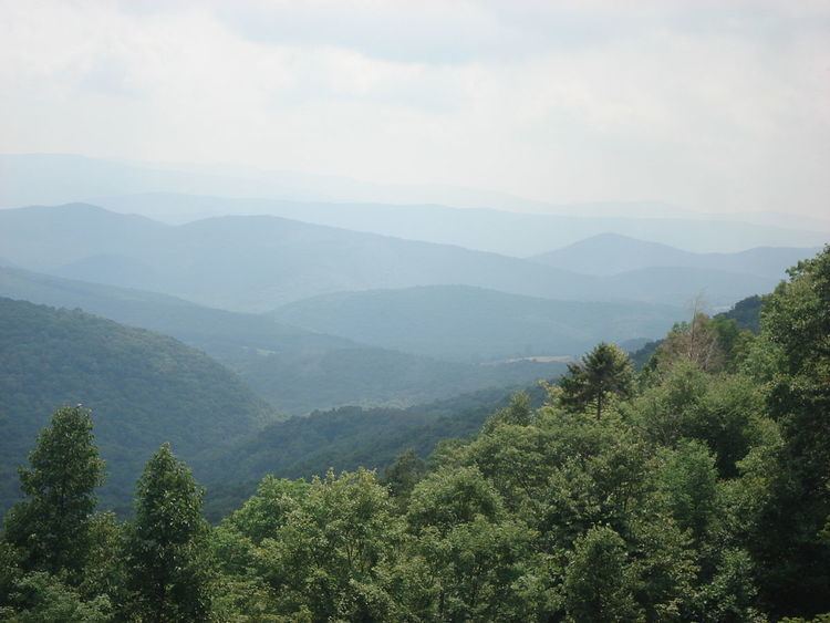
The MNF includes some major landform features such as the Allegheny Front and the western portion of the Ridge-and-valley Appalachians. Within the forest are most of the highest mountain peaks in the state, including the highest, Spruce Knob (4,863 ft), also the highest point in the Alleghenies. Approximately 75 tree species are found in the forest. Almost all of the trees are a second growth forest, grown back after the land was heavily cutover around the start of the 20th century. Species for which the forest is important include red spruce (Picea rubens), balsam fir (Abies balsamea), and mountain ash (Sorbus americana).
The MNF includes eight U.S. Wilderness Areas and several special-use areas, notably the Spruce Knob-Seneca Rocks National Recreation Area.
Monongahela national forest in 4k bushcraft backpacking hiking and camping the tea creek trail
Administration
The forest is administered from the main headquarters in Elkins, West Virginia, and four ranger districts. The forest has approximately 105 permanent employees, with this force augmented by senior citizens, temporary employees, and volunteers.
Ranger Districts
Monongahela National Forest is currently divided into four ranger districts. The Cheat-Potomac and Marlinton-White Sulphur Springs were formed by combining their namesake districts; in the merged districts, the offices for both original districts were retained.
History
The MNF was established following passage of the Weeks Act in 1911. This act authorized the purchase of land for long-term watershed protection and natural resource management following the massive cutting of the eastern forests in the late 19th and early 20th centuries. In 1915, 7,200 acres (29 km2) were acquired to begin the forest, called the "Monongahela Purchase", and on April 28, 1920 it became the "Monongahela National Forest". By the end of 1924, the MNF had a total ownership of some 150,367 acres (609 km2).
Although white-tail deer never became completely extirpated from the MNF, from the 1890s to the 1920s their numbers throughout the state (as with most of the eastern US) were being officially reported as "almost zero". In January 1930, eight deer procured from Michigan were released into the forest near Parsons. From 1937 to 1939, a total of 17 more deer were released in the Flatrock-Roaring Plains area of the Forest. These releases served as the nucleus for reestablishing the healthy breeding populations of eastern West Virginia. (By the mid-1940s, deer were so numerous in the area that crop farmers had to patrol their fields by night.)
In 1943 and 1944, as part of the West Virginia Maneuver Area, the U.S. Army used parts of the MNF as a practice artillery and mortar range and maneuver area before troops were sent to Europe to fight in World War II. Artillery and mortar shells shot into the area for practice are still occasionally found there today. Seneca Rocks and other area cliffs were also used for assault climbing instruction. This was the Army's only low-altitude climbing school.
The fisher (Martes pennanti), believed to have been exterminated in the state by 1912, was reintroduced during the winter of 1969. At that time 23 fishers were translocated from New Hampshire to two sites within boundaries of the MNF (at Canaan Mountain in Tucker County and Cranberry Glades in Pocahontas County).
In 1980, and again in 2005, the MNF was the venue for the annual counterculture "Rainbow Gathering".
In 1993, the Craig Run East Fork Rockshelter and Laurel Run Rockshelter in the Gauley Ranger District were listed on the National Register of Historic Places.
General
Trails
Natural features
Sensitive species
Geography
The MNF encompasses most of the southern third of the Allegheny Mountains range (a section of the vast Appalachian Mountains range) and is entirely within the state of West Virginia. Elevations within the MNF range from about 900 feet (270 m) at Petersburg to 4,863 feet (1,482 m) at Spruce Knob. A rain shadow effect caused by slopes of the Allegheny Front results in 60 inches (1,500 mm) of annual precipitation on the west side and about half that on the east side.
Headwaters of six major river systems are located within the forest: Monongahela, Potomac, Greenbrier, Elk, Tygart, and Gauley. Twelve rivers are currently under study for possible inclusion in the National Wild and Scenic Rivers System.
Ecology
The forest is noted for its rugged landscape with spectacular views, blueberry thickets, highland bogs and "sods", and open areas with exposed rocks. In addition to the second-growth forest trees, the wide range of botanical species found includes rhododendron, laurel on the moist west side of the Allegheny Front, and cactus and endemic shale barren species on the drier eastern slopes.
There are 230 known species of birds inhabiting the MNF: 159 are known to breed there, 89 are Neotropical migrants; 71 transit the forest during migration, but do not breed there, and 17 non-breeding species are Neotropical. The Brooks Bird Club (BBC) conducts an annual bird banding and survey project in the vicinity of Dolly Sods Scenic Area during migration (August - September). The forest provides habitat for 9 federally listed endangered or threatened species: 2 bird species, 2 bat species, 1 subspecies of flying squirrel, 1 salamander species, and 3 plant species. Fifty other species of rare/sensitive plants and animals also occur in the forest.
Larger animals and game species found in the forest include black bear, wild turkey, white-tailed deer, gray and fox squirrels, rabbits, snowshoe hare, woodcock, and grouse. Limited waterfowl habitat exists in certain places. Furbearers include beaver, red and gray fox, bobcat, fisher, river otter, raccoon and mink. Other hunted species include coyotes, skunks, opossums, woodchucks, crows, and weasels. There are 12 species of game (pan) fish and 60 species of nongame or forage fish. Some 90% of the trout waters of West Virginia are within the forest.
Recreation
The MNF is a recreation destination and major tourism attraction, hosting approximately 3 million visitors annually. The extensive backwoods road and trail system is available for hiking, mountain biking, horse riding. There are many miles of railroad grades that are a link in the recreation use of the forest. (The longest is the Glady to Durbin West Fork Railroad Trail which is 23 miles (37 km) long.) Recreation ranges from self-reliant treks in the wildernesses and backcountry areas to the challenges of mountain climbing to traditional developed site camping. Canoeing, hunting, trapping, fishing, and wildlife viewing are also popular uses.
Campgrounds
The following is a list of campgrounds in the forest:
Spruce Knob-Seneca Rocks National Recreation Area
U.S. Wilderness Areas
Registered National Natural Landmarks
Sites listed on the National Register of Historic Places
NB: Only sites actually on USFS land are listed here.Stands of old growth forest
Some 318 acres (1.29 km2) of true old growth forest have been documented within the MNF. The largest of these areas are: