
Length 11 km Country United States of America | Mouth Potomac River | |
 | ||
Location Prince William and Stafford counties, Virginia River mouth Potomac River
0 feet (0 m) | ||
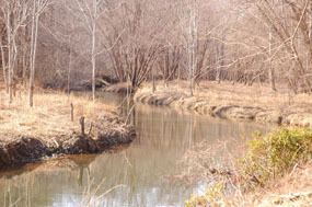
Chopawamsic Creek is a 6.8-mile-long (10.9 km) tributary of the Potomac River in Prince William and Stafford counties, Virginia. Chopawamsic Creek is formed by the confluence of the North and South Branches of Chopawamsic Creek and empties into the Potomac River south of Quantico at the Marine Corps Base Quantico's Air Station. Breckenridge Reservoir lies at the stream's confluence with the North and South Branches. Along with its North Branch, Chopawamsic Creek forms part of the boundary between Prince William and Stafford counties. The North Branch flows through part of the Chopawamsic Backcountry Area in Prince William Forest Park.
Contents
Map of Chopawamsic Creek, Virginia, USA
Variant namesEdit
The Board on Geographic Names decided upon Chopawamsic Creek as the stream's official name in 1891. Previously, it had been known by the following names according to the Geographic Names Information System:
TributariesEdit
Tributary streams are listed from source to mouth.