
Area 1,313 km² Area code Area codes 240 and 301 | Founded September 6, 1776 Population 1.017 million (2013) Unemployment rate 3.7% (Apr 2015) | |
 | ||
Country United States of America Demonym(s) Montgomery Countyan, MoCoite Colleges and Universities Montgomery College, Washington Adventist University, Uniformed Services University, L'Academie de Cuisine, National Labor College Points of interest National Capital Trolley M, Clara Barton National, Brookside Gardens, Maryland SoccerPlex, Glen Echo Park - Maryland | ||
Montgomery county maryland the best place to live work and play
Montgomery County, officially the County of Montgomery, is a county in the U.S. state of Maryland. As of the 2010 census, the population was 971,777, with a 2014 estimate putting the population at 1,030,447. It is the most populous county in Maryland. The county seat and largest municipality is Rockville, although the census-designated place of Germantown is the most populous place.
Contents
- Montgomery county maryland the best place to live work and play
- Map of Montgomery County MD USA
- Etymology
- Early history
- 19th century
- 20th and 21st centuries
- Home rule
- County Executive
- Annexation
- Geography
- Adjacent counties
- National protected areas
- Climate
- 2000 census
- 2010 census
- 2014
- Ethnic Groups
- Economy
- Top employers
- Government
- County executives
- Legislative body
- Budget
- Bi county agencies
- Liquor control
- History
- Federal representation
- Roads
- Bus
- Rail
- Air
- Education
- Montgomery County Public Schools
- Montgomery College
- Montgomery County Public Libraries
- The Smondrowski Amendment
- Religion
- Sports
- Montgomery County Agricultural Fair
- Cities
- Villages
- Special Tax Districts
- Census designated places
- Unincorporated communities
- References
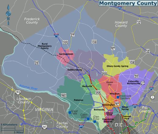
Map of Montgomery County, MD, USA
Montgomery County is included in the Washington–Arlington–Alexandria, DC–VA–MD–WV Metropolitan Statistical Area. Most of the county's residents live in unincorporated locales, of which the most built up are Silver Spring, and Bethesda, though the incorporated cities of Rockville and Gaithersburg are also large population centers as are many smaller but significant places.
As one of the most affluent counties in the United States, it also has the highest percentage (29.2%) of residents over 25 years of age who hold post-graduate degrees. In 2011, it was ranked by Forbes as the 10th richest in the United States, with a median household income of $92,213.
Montgomery County, like other inner Washington, D.C. suburban counties, contains many major U.S. government offices, scientific research and learning centers, and business campuses, which provide a significant amount of revenue for the county.
Etymology
The Maryland state legislature named Montgomery County after Richard Montgomery; the county was created from lands that had at one point or another been part of Frederick County. On September 6, 1776, Thomas Sprigg Wootton from Rockville, Maryland, introduced legislation, while serving at the Maryland Constitutional Convention, to create lower Frederick County as Montgomery County. The name, Montgomery County, along with the founding of Washington County, Maryland, after George Washington, was the first time in American history that counties and provinces in the thirteen colonies were not named after British referents. The name use of Montgomery and Washington County were seen as further defiance to Great Britain during the American Revolutionary War. The county's nickname of "MoCo" is derived from "Montgomery County", after the pattern of SoHo, Manhattan.
The county's motto, adopted in 1976, is "Gardez Bien", a phrase meaning "Watch Well". The county's motto is also the motto of its namesake's family.
Early history
Before European immigration, the land now known as Montgomery County was covered in a vast swath of forest crossed by the creeks and small streams that feed the Potomac and Patuxent rivers. A few small villages of the Piscataway, members of the Algonquian people, were scattered across the southern portions of the county. North of the Great Falls of the Potomac, there were few permanent settlements, and the Piscataway shared hunting camps and foot paths with members of rival peoples like the Susquehannocks and the Senecas.
Captain John Smith of the English settlement at Jamestown was probably the first European to explore the area, during his travels along the Potomac River and throughout the Chesapeake region.
These lands were claimed by Europeans for the first time when George Calvert, 1st Baron Baltimore was granted the charter for the colony of Maryland by Charles I of England. However, it was not until 1688 that the first tract of land in what is now Montgomery County was granted by the Calvert family to an individual colonist, a wealthy and prominent early Marylander named Henry Darnall. He and other early claimants had no intention of settling their families. They were little more than speculators, securing grants from the colonial leadership and then selling their lands in pieces to settlers. Thus, it was not until approximately 1715 that the first British settlers began building farms and plantations in the area.
These earliest settlers were English or Scottish immigrants from other portions of Maryland, German settlers moving down from Pennsylvania, or Quakers who came to settle on land granted to a convert named James Brooke in what is now Brookeville. Most of these early settlers were small farmers, growing wheat and a variety of other subsistence crops in addition to the region's main cash crop, tobacco. Many of the farmers owned slaves. They transported the tobacco they grew to market through the Potomac River port of Georgetown. Sparsely settled, the area's farms and taverns were nonetheless of strategic importance as access to the interior. General Edward Braddock's army traveled through the county on the way to its disastrous defeat at Fort Duquesne during the French and Indian War.
Like other regions of the American colonies, the region that is now Montgomery County saw protests against British taxation in the years before the American Revolution. In 1774, local residents met at Hungerford's Tavern and agreed to break off commerce with Great Britain. Following the signing of the Declaration of Independence, representatives of the area helped to draft the new state constitution and began to build a Maryland free of proprietary control. On September 6, 1776, the Maryland Constitutional Convention formed Montgomery County from lands that had at one point or another been part of Charles, Prince George's and Frederick Counties, naming it after General Richard Montgomery. The leaders of the new county chose as their county seat an area adjacent to Hungerford's Tavern near the center of the county, which later became Rockville. The newly formed Montgomery County supplied arms, food and forage for the Continental Army during the Revolution, in addition to soldiers.
In 1791, portions of Montgomery County, including Georgetown, were ceded to form the new District of Columbia, along with portions of Prince George's County, Maryland, as well as parts of Virginia that were later returned to Virginia.
19th century
In 1828, construction on the C&O Canal commenced and was completed in 1850. Laborers were. primarily Irish immigrants Throughout the 19th century, agriculture dominated the economy in Montgomery County, with slaves playing a significant role, though the vast majority of farmers owned 10 slaves or less rather than large plantations. In the first half of the 19th century, low tobacco prices and worn-out soil caused many tobacco farms to be abandoned. Crop production gradually shifted away from tobacco and toward wheat and corn. Prior to the Civil War, Montgomery County allied itself with other slaveholding counties in southern Maryland and the Eastern Shore. Montgomery County was important in the abolitionist movement, especially among the Quakers in the northern part of the county near Sandy Spring. Josiah Henson grew up as a slave on the Riley farm south of Rockville. He wrote about his experiences in a memoir which became the basis for Harriet Beecher Stowe's Uncle Tom's Cabin (1852). A slave cabin where he is believed to have spent time still stands at the end of a driveway off Old Georgetown Road.
Until 1860, only private schools existed in Montgomery County. Initially, schools for European American students were built. A school in Rockville for free African-Americans existed until 1866. Another school for African-Americans was opened by 1877 in Rockville.
Montgomery County's proximity to the nation's capital and split sympathies to North and South resulted in it being occupied by Union forces during the Civil War. The county was "invaded" on multiple occasions by Confederate and Union forces.
In 1855, work on the Metropolitan Branch of the Baltimore & Ohio Railroad began, in order to provide a route between Washington, D.C., and Point of Rocks, Maryland. In 1873, the railroad opened. The railroad spurred development at Takoma Park, Kensington, Garrett Park and Chevy Chase. By providing a much-needed transportation link, it also greatly increased the value of farmland and spurred the development of a dairy industry in the county.
During the Jim Crow era, masked mobs of local white men carried out two separate lynchings of African-American men in Montgomery County on Rockville's courthouse lawn. John Diggs was violently lynched in 1880 and Sydney Randolph similarly murdered in 1896. Neither man was found guilty in a court of law. Nor was anyone punished for the lynchings. On that same lawn, the Maryland Historical Society maintains a monument to the Confederate army as "heroes of the thin grey line", because Montgomery County, like the rest of Maryland, was divided over the issue of secession. One vocal sociologist has claimed Montgomery County was not welcoming of the Confederates during the Civil War. No memorial exists for victims of Montgomery County's lynchings.
20th and 21st centuries
On July 1, 1922, the Montgomery County Police Department was established. Prior to that time, law enforcement duties rested in the Montgomery County Sheriff and designated constables. In 1922, the police department consisted of three to six officers who were appointed to two-year terms by the Board of County Commissioners, one of whom would be appointed as Chief. In 1927, the police department was enlarged to twenty officers.
Home rule
The county began with most legislative power in the hands of the Maryland state government, with a five-person Montgomery County Board of Commissioners who oversaw the administration of the county but could neither pass county laws nor enact policies.
In 1915, Maryland amended its constitution. According to the constitutional amendment, a county's residents may propose a petition to create a nonpartisan Charter Board. If the petition receives signatures from at least twenty percent of the county's registered voters, all county residents would vote to select the members of the Charter Board during the next general election. The Charter Board would be authorized to draft a new system of county government, which could include a county council with the power to enact legislation and policies. Charter Board's proposal would then be voted upon by registered voters during the following general election, and it would be enacted if approved by the voters.
The county commissioners authorized the Brookings Institution to study the existing county government structure and suggest recommendations in 1938. The 720-page report opined that the county had outgrown its form of government. The study recommended the creation of a nonpartisan county council consisting of nine members representing defined districts of the county who could pass legislation, determine policy, and control over the administration of the county. The study also recommended the hiring of a county administrator, the creation of an independent comptroller in charge of county finances, and a civil service commission. The Montgomery County Civic Federation praised the study for its comprehensiveness. The county commissioners appointed a citizen's committee to determine how to enact the study's recommendations. The county commissioners strongly criticized the recommendation to create a county council, both because the council would be nonpartisan and because each county resident would be able to vote for only one representative rather than for all nine.
In 1942, Montgomery County Charter Committee was organized, which was formed primarily to circulate petitions to form a Charter Board. The Charter Board petitioned to form a county council with the power to pass laws without the consent of the Maryland General Assembly and with authority over the administration the county. While the Democratic Party did not explicitly denounce the charter, it issued a statement calling out the ostensibly nonpartisan movement for hidden partisan goals and claimed that backers of the charter petition for their alleged personal and political attacks on the Democratic Party and its officials. The newly formed Independent Party endorsed the charter, praising county residents' goal of improving their form of government. In the November 1942 election, county residents voted in favor of forming a Charter Board.
In 1943, the Charter Board released its draft charter. The council would have nine unpaid members, of which five would represent each of five single-member districts and four would represent the county at-large. Council seats would be nonpartisan, each seat would be held for four years, and elections would occur every two years. The council would have the power to enact legislation and hire a county manager, to whom all governmental department heads would report. All sessions of the council would be open to the public. The office of county treasurer would be abolished and replaced by a director of finance, who would be responsible for assessment and collection of taxes, assessments, and licenses, custody and disbursement of public funds and property, and preparation of monthly financial statements. A department of public works, department of education, department of safety, department of welfare, and department of health would also be created.
The Montgomery County Charter Board opened its campaign headquarters in Bethesda, to serve as an information center regarding the draft charter. The Charter Board emphasized that the draft charter would allow for county affairs to be decided by local representatives rather than by a vote of members of the Maryland General Assembly who represent citizens of all parts of the state. Another group opposing the draft charter opened its headquarters in Bethesda. The group said there was no good reason to abolish the functional state-level system already in place, and that the draft charter would increase taxes and establish heads of governmental agencies with indefinite terms who are not directly accountable to the public. The group also said that making the council seats nonpartisan would go against the country's political history. The editorial board of The Washington Post supported the draft charter. The Montgomery County League of Women Voters also endorsed the draft charter.
In a near-record turnout, a 1946 vote to enact a home-rule charter failed by a vote of 14,471 to 13,270. Following the vote, proponents of the charter said they would not give up the fight.
Several months later, Montgomery County Democratic Party leader Col. E. Brooke Lee said he would support Montgomery County home rule by way of an act of the Maryland state legislature. Lee proposed a bill to create a position of county supervisor, who would be in charge of routine county business, would appoint county employees subject to civil service rules and regulations, would supervise expenditures, and would prepare the operating and capital budgets. The bill did not disband the county commissioners or create a county council. The bill passed the state legislature and was signed by Governor Herbert R. O'Conor in 1945. The county commissioners appointed Willard F. Day to the position.
In 1948, by a vote of 17,809 in favor and 13,752 against, voters approved a charter for a "Council-Manager" form of government, making Montgomery County the first home-rule county in Maryland. The charter created an elected seven-member County Council with the power to pass local laws. All seven Council Members would be elected at-large by all county residents. Five would have to live in five different residence districts, while the other two could live anywhere within the county. The Council would serve as both the legislative and executive functions of the county. Council members would elect one of their own to serve as president of the Council. The charter also authorized the hiring of a county manager, the top administrative official, who could be dismissed by the Council after a public hearing. The charter created a department of public works, department of finance, and office of the county attorney, while it abolished the positions of county treasurer and police commissioner. The first County Council was elected in 1949.
County Executive
In 1962, a county civic group advocated for the election of a county executive. The group's report said that the new position would give citizens another place to go if their concerns were refused by the Montgomery County Council. The group said that the fact that the county had four appointed county managers in thirteen years demonstrates that establishing the position in 1948 had not been a stunning success. The group also advocated for nonpartisan elections for council members. Among the reasons for the suggested changes in governance is the fact that the county's population had more than doubled since the governmental system had been established in 1948.
In 1966, the Montgomery County Council adopted a proposed charter amendment to create a new elected position of County Executive. Elected to a four-year term, the County Executive could veto legislation passed by the County Council, although five members of the County Council could vote to overrule the veto. All Council Members would continue to be at-large, but they would need to live in seven different residence districts. Republicans favored a referendum on the proposed charter amendment, while Democrats favored it in principle but urged the specific amendment's defeat because the duties of the County Executive were not specific enough. In the referendum held in September 1966, the referendum was defeated, with 57 percent of voters opposed.
In February 1967, the Montgomery County Council formed a commission to draft a charter amendment to elect a county executive. The commission's plan was to separate the legislative and executive functions of government. The county council would continue to be the legislative branch of county government, and an elected full-time County Executive who could veto legislation passed by the Council; it would take five votes by the Council to override a veto. The County Executive would hire a chief administrative officer to supervise the daily operations of the government. All Council Members would be elected at-large by all county residents, but five of the seven would need to live in each of five different residential districts of substantially equal population. In November 1968, the charter amendment was approved, with 53 percent of votes in favor.
In the first election for County Executive, held in 1970, Republican James P. Gleason defeated Democrat William W. Greenhalgh by a margin of 420 votes.
In November 1986, voters amended the Charter to increase the number of Council seats in the 1990 election from seven to nine. Now five members are elected by the voters of their council district and four are elected at-large. Each voter may vote for five council members; four at-large and one from the district in which they reside.
Annexation
In November 1995, the City of Takoma Park held a state-sponsored referendum asking whether the portions of the city in Prince George's County should be annexed to Montgomery County or vice versa. The majority of votes in the referendum were in favor of unification of the entire city in Montgomery County. Following subsequent approval by both counties' councils and the Maryland General Assembly, the county line was moved to include the entire city into Montgomery County (including territory in Prince George's County newly annexed by the city) on July 1, 1997. This added about 800 residents to Montgomery County's population.
Geography
According to the U.S. Census Bureau, the county has a total area of 507 square miles (1,310 km2), of which 491 square miles (1,270 km2) is land and 16 square miles (41 km2) (3.1%) is water. Montgomery County lies entirely inside the Piedmont plateau. The topography is generally rolling. Elevations range from a low of near sea level along the Potomac River to about 875 feet in the northernmost portion of the county north of Damascus. Relief between valley bottoms and hilltops is several hundred feet.
When Montgomery County was created in 1776, its boundaries were defined as "beginning at the east side of the mouth of Rock Creek on Potowmac river [sic], and running with the said river to the mouth of Monocacy, then with a straight line to Par's spring, from thence with the lines of the county to the beginning".
The county's boundary forms a sliver of land at the far northern tip of the county that is several miles long and averages less than 200 yards wide. In fact, a single house on Lakeview Drive and its yard is sectioned by this sliver into 3 portions, each separately contained within Montgomery, Frederick and Howard Counties. These jurisdictions and Carroll County meet at a single point at Parr's Spring on Parr's Ridge.
Adjacent counties
National protected areas
Climate
Montgomery County lies within the northern portions of the humid subtropical climate. It has four distinct seasons, including hot, humid summers and cool winters.
Precipitation is fairly evenly distributed throughout the year, with an average of 43 inches (110 cm) of rainfall. Thunderstorms are common during the summer months, and account for the majority of the average 35 days with thunder per year. Heavy precipitation is most common in summer thunderstorms, but drought periods are more likely during these months because summer precipitation is more variable than winter.
The mean annual temperature is 55 °F (13 °C). The average summer (June–July–August) afternoon maximum is about 85 °F (29 °C) while the morning minimums average 66 °F (19 °C). In winter (December–January–February), these averages are 44 °F (7 °C) and 28 °F (−2 °C). Extreme heat waves can raise readings to around and slightly above 100 °F (38 °C), and arctic blasts can drop lows to −10 °F (−23 °C) to 0 °F (−18 °C). For Rockville, the record high is 105 °F (41 °C) in 1954, while the record low is −13 °F (−25 °C).
Lower elevations in the south, such as Silver Spring, receive an average of 17.5 inches (44 cm) of snowfall per year. Higher elevations in the north, such as Damascus, receive an average of 21.3 inches (54 cm) of snowfall per year. During a particularly snowy winter, Damascus received 79 inches (200 cm) during the 2009–2010 season.
2000 census
In 2000, significant national ethnic groups included people of Irish (8.5%), German (8.1%), English (6.8%) and American (5.0%) ancestry according to Census 2000.
There were 324,565 households of which 35% had children under the age of 18 living with them, 55.2% were married couples living together, 10.5% had a female householder with no husband present, and 30.9% were non-families. 24.4% of all households were made up of individuals, and 7.7% had someone living alone who was 65 years of age or older. The average household size was 2.66 and the average family size was 3.19.
25.4% of the population was under the age of 18, 6.9% from 18 to 24, 32.3% from 25 to 44, 24.2% from 45 to 64, and 11.2% who were 65 years of age or older. The median age was 37 years. For every 100 females there were 92.1 males. For every 100 females age 18 and over, there were 88.1 males.
In 2000, there were 334,632 housing units at an average density of 675 per square mile (261/km2).
Montgomery County has the tenth highest median household income in the United States, and the second highest in the state after Howard County as of 2011. The median household income in 2007 was $89,284 and the median family income was $106,093. Males had a median income of $66,415 versus $52,134 for females. The per capita income for the county was $43,073. About 3.3% of families and 4.6% of the population were below the poverty line, including 4.6% of those under age 18 and 4.6% of those age 65 or over.
Since the 1970s, the county has had in place a Moderately Priced Dwelling Unit (MPDU) zoning plan that requires developers to include affordable housing in any new residential developments that they construct in the county. The goal is to create socioeconomically mixed neighborhoods and schools so the rich and poor are not isolated in separate parts of the county. Developers who provide for more than the minimum amount of MPDUs are rewarded with permission to increase the density of their developments, which allows them to build more housing and generate more revenue. Montgomery County was one of the first counties in the U.S. to adopt such a plan, but many other areas have since followed suit.
2010 census
As of the 2010 United States Census, there were 971,777 people, 357,086 households, and 244,898 families residing in the county. The population density was 1,978.2 inhabitants per square mile (763.8/km2). There were 375,905 housing units at an average density of 765.2 per square mile (295.4/km2). The racial makeup of the county was 57.5% white, 17.2% black or African American, 13.9% Asian, 0.4% American Indian, 0.1% Pacific islander, 7.0% from other races, and 4.0% from two or more races. Those of Hispanic or Latino origin made up 17.0% of the population. In terms of ancestry, 10.7% were German, 9.6% were Irish, 7.9% were English, and 2.9% were American.
Of the 357,086 households, 35.7% had children under the age of 18 living with them, 53.4% were married couples living together, 11.3% had a female householder with no husband present, 31.4% were non-families, and 25.0% of all households were made up of individuals. The average household size was 2.70 and the average family size was 3.22. The median age was 38.5 years.
The median income for a household in the county was $93,373 and the median income for a family was $111,737. Males had a median income of $71,841 versus $55,431 for females. The per capita income for the county was $47,310. About 4.0% of families and 6.0% of the population were below the poverty line, including 7.2% of those under age 18 and 6.3% of those age 65 or over.
2014
The United States Census Bureau estimates the county's population as 1,030,447 as of 2014.
Of residents age 25 or older, 91.2% graduated high school, and 57.1% had a bachelor's degree.
The ethnic makeup of the county was estimated to be the following in 2013:
In addition, 18.3% were Hispanic or Latino, of any race.
Of the county's population, 32.6% were born outside the United States.
45,776 veterans live in the county.
Ethnic Groups
The county has a sizable Jewish population, and is home to an increasing number of affluent Indians, Armenians and Iranians. There is also a large population of African immigrants to the United States.
Economy
Montgomery County is an important business and research center. It is the epicenter for biotechnology in the Mid-Atlantic region. Montgomery County, as third largest biotechnology cluster in the U.S., holds a large cluster and companies of large corporate size within the state. Biomedical research is carried out by institutions including Johns Hopkins University's Montgomery County Campus (JHU MCC), and the Howard Hughes Medical Institute (HHMI). Federal government agencies engaged in related work include the Food and Drug Administration (FDA), the National Institutes of Health (NIH), the Uniformed Services University of the Health Sciences (USUHS), and the Walter Reed Army Institute of Research.
Many large firms are based in the county, including Discovery Communications, Coventry Health Care, Lockheed Martin, Marriott International, Host Hotels & Resorts, Travel Channel, Ritz-Carlton, Robert Louis Johnson Companies (RLJ Companies), Choice Hotels, MedImmune, TV One, BAE Systems Inc, Hughes Network Systems and GEICO.
Other U.S. federal government agencies based in the county include the National Oceanic and Atmospheric Administration (NOAA), Nuclear Regulatory Commission (NRC), U.S. Department of Energy (DOE), the National Institute of Standards and Technology (NIST), the Walter Reed National Military Medical Center (WRNMMC), and the U.S. Consumer Product Safety Commission (CPSC).
Downtown Bethesda and Silver Spring are the largest urban business hubs in the county; combined, they rival many major city cores.
Top employers
According to the county's comprehensive annual financial reports, the top employers by number of employees in the county are the following. "NA" indicates not in the top ten employers for the year given.
Government
Montgomery County was granted a charter form of government in 1948.
The present County Executive/County Council form of government of Montgomery County dates to November 1968 when the voters changed the form of government from a County Commission/County Manager system, as provided in the original 1948 home rule Charter.
The Montgomery County Police Department provides county-wide law enforcement services, although several cities including Rockville and Gaithersburg maintain their own police departments to complement MCPD. Maryland State Police patrol Interstate highways 495 (the "Beltway") and 270 and assist county and city police in investigation of some major crimes.
County executives
The office of the county executive was established in 1970. The first executive was James P. Gleason. The current executive is Isiah "Ike" Leggett, who was sworn in for his first term on December 4, 2006. He was reelected on November 2, 2010 and on November 4, 2014.
Legislative body
The last Republican serving on the Montgomery County Council, Howard A. Denis of District 1 (Potomac/Bethesda), was defeated in 2006. The board has since been all-Democratic. The members of the County Council for the 2014–2018 term are:
Budget
Montgomery County has a budget of $2.3 billion. Approximately $128 million are invested in Montgomery County Public Schools.
Bi-county agencies
Montgomery and Prince George's Counties share a bi-county planning and parks agency in the Maryland-National Capital Park and Planning Commission (often referred to as Park and Planning or its initials M-NCPPC by county residents) and a public bi-county water and sewer utility in the Washington Suburban Sanitary Commission (WSSC).
Liquor control
Montgomery County is an alcoholic beverage control county. Beer and wine may still be sold in individual stores and at a single location within the county for a store chain.
History
Until 1964, only three restaurants in the county had liquor licenses to serve liquor by the drink. The county stopped issuing liquor licenses to all other restaurants under a law that had existed since Prohibition.
Following a voter referendum, restaurants and bars could apply for county permits to sell liquor by the drink. The dry towns of Kensington, Poolesville, and Takoma Park were allowed to keep their own bans in place.
Anchor Inn in Wheaton was the first establishment to serve liquor in the county under the new law.
Federal representation
Since 2013, Montgomery has been represented in the U.S House of Representatives by John Sarbanes of the 3rd district, John Delaney of the 6th district, and Chris Van Hollen of the 8th district. After Van Hollen won the vacant US Senate seat in the 2016 election, his 8th district seat was taken over by Jamie Raskin.
Roads
Montgomery County is approximately bisected northwest-southeast by Interstate 270, a connector linking Interstate 70 with Washington. I-270 divides in North Bethesda with its primary roadway connecting to the eastbound Capital Beltway (Interstate 495), and a spur connecting to southbound I-495 as it approaches Northern Virginia. Another spur highway, Interstate 370, connects Interstate 270 with the Shady Grove Metro station.
An east-west toll freeway, the Intercounty Connector (Maryland Route 200), also known as the ICC, links Interstate 370 and I-270 with U.S. 29; Interstate 95, and terminates at U.S. 1 in Laurel, Prince George's County. The first portion of the freeway, from I-370 to Georgia Avenue, opened in February 2011. The second portion, from Georgia Avenue to I-95, opened in November 2011. The final, 1.5 mile section of highway, from I-95 to Route 1, opened in November 2014.
Roughly paralleling 270 is Maryland Route 355, a surface street known for much of its length as Rockville Pike or simply "The Pike". In its southern reaches it is known as Wisconsin Avenue, while in the north it is known as Frederick Road, or Frederick Ave in Gaithersburg; in the northern half of Rockville (from Town Center north), it is named Hungerford Drive.
Other major routes include Maryland Route 190 (River Road); Maryland Route 97 (Georgia Avenue); Maryland Route 650 (New Hampshire Avenue), Maryland Route 185 (Connecticut Avenue), Randolph Road/Montrose Road, Maryland Route 28 (Darnestown Road, Montgomery Avenue and Norbeck Road), and Maryland Route 27 (Father Hurley Blvd., Ridge Road). U.S. Route 29 parallels the eastern border of the county; first as Georgia Avenue in Silver Spring, then Colesville Road, and thence as Columbia Pike through Burtonsville and into Howard County.
The Montgomery County government has strongly supported the use of automated traffic enforcement on county roads. In 2007 this county became the first jurisdiction in Maryland to introduce automated speed cameras on roads with speed limits up to 35 mph, issuing fines of $40 by mail. Red light cameras with fines of $75 are also in use.
A 1970s-era computer system coordinates the setting of 750 traffic lights. In 2009, the computer system failed for a brief period, causing considerable problems.
Bus
Montgomery County operates its own bus public transit system, known as Ride On. Major routes closer to its rail service area are also covered by WMATA's Metrobus service.
Rail
Montgomery County is served by three passenger rail systems.
Amtrak, the U.S. national passenger rail system, operates its Capitol Limited to Rockville, between Washington Union Station and Chicago Union Station.
The Brunswick line of the MARC commuter rail system makes stops at Silver Spring, Kensington, Garrett Park, Rockville, Washington Grove, Gaithersburg, Metropolitan Grove, Germantown, Boyds, Barnesville, and Dickerson, where the line splits into its Frederick and Martinsburg branches.
Both suburban arms of the Red Line of the Washington Metro serve Montgomery County. It follows the CSX right of way to the west, roughly paralleling Route 355 from Friendship Heights to Shady Grove. The eastern side runs between the two tracks of the CSX right of way from Washington Union Station to Silver Spring, and roughly parallels Georgia Avenue, from Silver Spring to Glenmont.
There has been much debate on the construction of two new transitways, both of which are still in the early stages of design. The Purple Line would run "cross-town" connecting nodes in Montgomery and Prince George's Counties near the Beltway; and the Corridor Cities Transitway would provide an extension of the Red Line corridor from Gaithersburg to Germantown and beyond.
Air
The Montgomery County Airpark (FAA GAI, ICAO KGAI), a general aviation facility in Gaithersburg, is the major airport in the county. Davis Airport (FAA Identifier W50), a privately owned airstrip, is located in Laytonsville on Hawkins Creamery Road. Commercial air service is provided at the nearby Ronald Reagan Washington National, Washington Dulles International, and BWI Airports.
Education
Educative system is conformed by Montgomery County Public Schools, Montgomery College and other institutions in the area.
Montgomery County Public Schools
Elementary and secondary public schools are operated by the Montgomery County Public Schools and has a budget of $2.52 billion for 2018, 2.6% up from the annual budget for 2017.
MCPS operates under the jurisdiction of an elected Board of Education. Its current members are:
Montgomery College
The county is also served by Montgomery College, a public, open access community college that has a budget of 950 million USD for 2015. The county has no public university of its own, but the state university system does operate a facility called Universities at Shady Grove in Rockville that provides access to baccalaureate and Master's level programs from several of the state's public universities.
Montgomery County Public Libraries
Montgomery County Public Libraries (MCPL) is the public library system for residents of Montgomery County, Maryland. The system includes 23 individual libraries. It has a budget 38 US$ Millions for 2015.
The "Smondrowski Amendment"
On November 11, 2014, the Board approved an amendment introduced by Rebecca Smondrowksi to modify the school calendar to delete all references to religious holidays such as Christmas, Easter, Yom Kippur and Rosh Hashanah. The amendment was in response to requests by an interfaith organization called Equality for Eid which asked that the listing for the Islamic holiday, Eid Al-Adha be listed alongside Yom Kippur which occurred on the same day.
The Smondrowski amendment received both national and international attention. Criticism of the Smondrowski amendment came from a variety of sources including the Montgomery County Executive, Isiah Leggett, and congressman John Delaney.
Religion
Montgomery County is religiously diverse. Of Montgomery County's population, according to the Associations of Religion Data, 13% is Catholic, 5% is Baptist, 4% is Evangelical Protestant, 3% is Jewish, 3% is Methodist/Pietist, 2% is Adventist, 2% is Presbyterian, 1% is Episcopalian/Anglican, 1% is Mormon, 10% is Muslim, 1% is Lutheran, 1% is Eastern Orthodox, 1% is Pentecostal, 1% is Buddhist, and 1% is Hindu.
The Seventh-day Adventist Church maintains its General Conference headquarters in Silver Spring, Maryland.
Sports
Bethesda's Congressional Country Club has hosted four Major Championships, including three playings of the U.S. Open, most recently in 2011 which was won by Rory McIlroy. The Club also hosts the Quicken Loans National, an annual event on the PGA Tour which benefits the Tiger Woods Foundation. Previously, neighboring TPC at Avenel hosted the Booz Allen Classic.
The Bethesda Big Train, Rockville Express, and Silver Spring-Takoma Thunderbolts all play college level wooden bat baseball in the Cal Ripken Collegiate Baseball League.
Montgomery County is home of the Montgomery County Swim League, a youth (ages 4–18) competitive swimming league composed of ninety teams based at community pools throughout the county.
There are future possibilities of a minor league baseball team forming to play for the Atlantic League of Professional Baseball to represent Montgomery County.
Montgomery County Agricultural Fair
Since 1949 the Montgomery County Agricultural Fair, the largest in the state, showcases farm life in the county. The week long event offers family events, carnival rides, live animals, entertainment and food. Visitors can also view entries of canned and baked goods, clothing, quilts and produce from local county farmers.
Cities
Villages
Special Tax Districts
Occupying a middle ground between incorporated and unincorporated areas are Special Tax Districts, quasi-municipal unincorporated areas created by legislation passed by either the Maryland General Assembly or the county. The Special Tax Districts generally have limited purposes, such as providing some municipal services or improvements to drainage or street lighting. Special Tax Districts lack home rule authority and must petition their cognizant governmental entity for changes affecting the authority of the district. The four incorporated villages of Montgomery County and the town of Chevy Chase View were originally established as Special Tax Districts. Four Special Tax Districts remain in the county:
Census-designated places
Unincorporated areas are also considered as towns by many people and listed in many collections of towns, but they lack local government. Various organizations, such as the United States Census Bureau, the United States Postal Service, and local chambers of commerce, define the communities they wish to recognize differently, and since they are not incorporated, their boundaries have no official status outside the organizations in question. The Census Bureau recognizes the following census-designated places in the county: