
Length 44 km Mouth elevation 0 | Country United States of America | |
 | ||
River mouth Potomac River0 feet (0 m) | ||
368 aquia creek road stafford va presented by hagerman group
Aquia Creek ( /ɑːˈkwaɪə/) is a 27.6-mile-long (44.4 km) tributary of the tidal segment of the Potomac River and is located in northern Virginia. The creek's headwaters lie in southeastern Fauquier County, and it empties into the Potomac at Brent Point in Stafford County, 45 miles (72 km) south of Washington, D.C.
Contents
- 368 aquia creek road stafford va presented by hagerman group
- Map of Aquia Creek Virginia USA
- HistoryEdit
- References
Map of Aquia Creek, Virginia, USA
HistoryEdit
The Public Quarry at Government Island in the creek served as the source for Aquia Creek sandstone. This sandstone was used in numerous public buildings; the National Capitol Columns were quarried in the early 1800s, and transported to Washington on a barge.
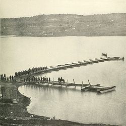
In an early American Civil War skirmish, the Battle of Aquia Creek, three US gunships fired on a battery garrison during the Union campaign to blockade Chesapeake Bay (May–June 1861). There were an estimated 10 casualties.