
- left North Fork Length 90 km Basin area 7,607 km² | - right South Fork Basin area 7,607 km² | |
 | ||
Sources North Fork Shenandoah River, South Fork Shenandoah River Cities | ||
The Shenandoah River /ˌʃɛnənˈdoʊə/ is a tributary of the Potomac River, 55.6 miles (89.5 km) long with two forks approximately 100 miles (160 km) long each, in the U.S. states of Virginia and West Virginia. The principal tributary of the Potomac, the river and its tributaries drain the central and lower Shenandoah Valley and the Page Valley in the Appalachians on the west side of the Blue Ridge Mountains, in northwestern Virginia and the Eastern Panhandle of West Virginia.
Contents
- Map of Shenandoah River United States
- CourseEdit
- GeologyEdit
- Environmental issuesEdit
- HistoryEdit
- In popular cultureEdit
- RecreationEdit
- South Fork Shenandoah RiverEdit
- South Fork tributariesEdit
- North Fork Shenandoah RiverEdit
- References
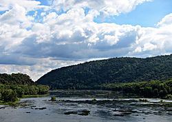
Map of Shenandoah River, United States
CourseEdit
The Shenandoah River is formed northeast of Front Royal near Riverton, by the confluence of the South Fork and the North Fork. It flows northeast across Warren County, passing underneath Interstate 66 1 mile (1.6 km) from its formation. Beyond the I-66 bridge the river flows through a set of bends before turning to the northeast again, crossing into Clarke County 11 miles (18 km) below I-66. Five miles (8 km) downriver from the Clarke County border, the Shenandoah passes under U.S. Route 50 and then passes through a triple bend. 14.5 miles (23.3 km) below the Route 50 bridge, the river passes underneath State Route 7 and then continues northeast another 8 miles (13 km) where it crosses into Jefferson County in West Virginia, in the extreme eastern tip of the state. Once in West Virginia the river completes six large bends before joining with the Potomac from the south near Harpers Ferry, 20 miles (32 km) from the Virginia-West Virginia border.
GeologyEdit
The Shenandoah valley is underlain by limestone. The fertile soil made it a favored place for early settlement. It continues to be a major agricultural area of Virginia and West Virginia. Some karst topography is evident, and the limestone is honeycombed with caves. Several have been developed as commercial tourist attractions, including Luray Caverns, Shenandoah Caverns, and Skyline Caverns.
On the riverbank a few miles above Harper's Ferry is said to be a cave with an opening just large enough for a mounted rider to squeeze through. It widened in the interior to a spacious room where hundreds of Col. John Mosby's raiding troops are said to have hidden from pursuing Union cavalry.
Environmental issuesEdit
Since 2005, the Shenandoah River has experienced several springtime fish kills that have affected several of its native fish species. In 2005, redbreast sunfish and smallmouth bass along a 100-mile (160 km) stretch of the South Fork Shenandoah River began dying of lesions caused by bacteria and fungi. Although the fish kill eventually wiped out 80% of the adult redbreast sunfish and smallmouth bass, juvenile populations appeared to be unaffected. The following year more-localized fish kills in Clarke County spread to two of the Shenandoah's three species of sucker: the shorthead redhorse and the northern hogsucker – the former suffering from similar lesions witnessed in the previous year's fish kill. Virginia's Department of Environmental Quality received reports of fish kills near Elkton and between Bentonville and Front Royal in late April 2007 and observed fish exhibiting lesions and strange behavior.
HistoryEdit
Various accounts tell the origin of the name. According to one, General George Washington named the valley (and river) in honor of Skenandoa (or Shenandoah), an Oneida "pine tree chief" based in New York, who led hundreds of Oneida and Tuscarora warriors in support of the American rebels on the frontier during the Revolutionary War. He also sent much needed corn to Washington and his troops during their hard winter at Valley Forge, Pennsylvania in 1777-1778. It is also said to be named after the Senedo people, a little-documented tribe said to have lived on the north fork of the river and destroyed by the Catawba, some time between 1650 and 1700.
In popular cultureEdit
The American folk song "Oh Shenandoah" has been recorded in the 20th century by a number of notable artists. The song may or may not refer to the Shenandoah River or Valley.
The Shenandoah River figures prominently in John Denver's "Take Me Home, Country Roads," which associates the river with the state of West Virginia. Only the last 20 miles (32 km) of the river are in the Eastern Panhandle of West Virginia; more than 92% of the river and its forks and tributaries flow through Virginia.
The original song "Shenandoah River" is included on the 2011 album Middle of Everywhere by Pokey LaFarge and the South City Three of Saint Louis, Missouri.
RecreationEdit
The Shenandoah River is a very popular river for canoeing, river tubing, and white-water recreation such as rafting and kayaking (class I-III in season, II-III+ during the spring run-off), and several commercial outfitters offer a variety of guided trips and rentals. Those willing to brave the colder water of spring will be rewarded with a more challenging big-water experience.
South Fork Shenandoah RiverEdit
The South Fork is formed at Port Republic in southern Rockingham County, by the confluence of the North River and South River. It flows 98.5 miles (158.5 km) northeast in a tight meandering course, past Elkton and Shenandoah, through Page Valley, with the Blue Ridge Mountains to the east and the Massanutten Mountain range to the west.
South Fork tributariesEdit
North Fork Shenandoah RiverEdit
The North Fork is 105 miles (169 km) long and rises in northern Rockingham County, along the eastern flank of Shenandoah Mountain in the George Washington National Forest. At its formation, the principal feeder on the North Fork is the German River. The North Fork flows initially southeast, down from the mountains, then northeast through a valley across Shenandoah County, along the western side of Massanutten Mountain. It flows past Woodstock and Strasburg. On the north end of the ridge it turns briefly southeast to join the South Fork from the northwest to form the Shenandoah.