
Max. length 6.6 miles (10.6 km) Max depth 90 m Length 10,622 m Outflow location Potomac River | Surface area 952 acres (3.85 km) Surface elevation 445 m Area 3.85 km² Inflow source Potomac River | |
 | ||
Primary inflows Primary outflows North Branch Potomac River | ||
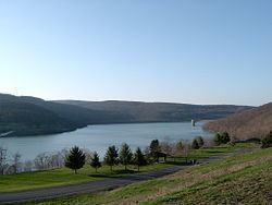
Jennings Randolph Lake is a reservoir of 952 acres (3.85 km2) located on the North Branch Potomac River in Garrett County, Maryland and Mineral County, West Virginia. It is approximately eight miles upstream of Bloomington, Maryland, and approximately five miles north of Elk Garden, West Virginia.
Contents
- Map of Jennings Randolph Lake United States
- Construction and managementEdit
- Planned hydroelectric facilityEdit
- Recreational facilitiesEdit
- References
Map of Jennings Randolph Lake, United States
Construction and managementEdit
The lake was constructed by the U.S. Army Corps of Engineers, as authorized by the Flood Control Act of October 23, 1962 (Public Law 87-874) and is described in House Document No. 469, 87th United States Congress, second session. Construction of the lake was completed in 1981, and resulted in the flooding of the community of Shaw, West Virginia and the realignment of West Virginia Route 46. Originally named Bloomington Lake, it was later renamed for West Virginia Senator Jennings Randolph. The lake, which serves as an emergency reservoir for the Washington, D.C. metropolitan area, is managed by the Corps of Engineers. Coordination of the lake's use for water supply purposes is managed by the Interstate Commission on the Potomac River Basin (ICPRB).
The impoundment also collects acid mine drainage from coal mines located upstream, which improves the water quality of the river downstream.
Planned hydroelectric facilityEdit
In 2008 Fairlawn Hydroelectric Company filed a proposal with the Federal Energy Regulatory Commission (FERC) to construct a hydroelectric facility at the dam. FERC approved a license for a 14 MW facility on April 30, 2012. Construction has not started as of 2015.