
Mouth elevation 0 | Length 22 km | |
 | ||
River mouth Potomac River0 feet (0 m) Similar Windy Run, Kingman Lake, Burke Lake, Quantico Creek, Georgetown Reservoir | ||
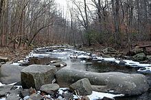
Pohick Creek is a 14.0-mile-long (22.5 km) tributary stream of the Potomac River in Fairfax County in the U.S. state of Virginia. It takes its name from the Pohick Native American tribe once prevalent in the area.
Contents
Map of Pohick Creek, Virginia, USA
Pohick Creek forms in the vicinity of Burke and flows southeast past the western edge of Fort Belvoir to empty into the tidal Pohick Bay, which itself empties, along with Accotink Bay, into Gunston Cove, an embayment of the tidal Potomac River. Pohick Creek is a popular stream for whitewater kayaking, rafting, and paddling, providing Class II and III rapids along a 5.5-mile (8.9 km) stretch between Hooes Road (Virginia Secondary Route 636) and the Richmond Highway (U.S. Route 1) at Lorton.
Several tributaries of the Pohick Creek are impounded by dams constructed under the Watershed Protection and Flood Prevention Act to prevent soil erosion and flooding. Originally eight dams were planned, but from 1970 to 1985, only six were actually built.
Variant names
The following variant names have been listed on the Geographic Names Information System by the United States Geological Survey.