
Length 2 km | Mouth elevation 0 | |
 | ||
River mouth Potomac River0 feet (0 m) | ||
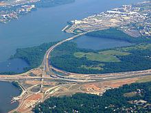
Oxon Creek is a cove on the Potomac River which straddles the border between Washington, D.C. and Prince George's County, Maryland just north of Interstate 495 (Capital Beltway) at Woodrow Wilson Bridge. The tributary stream is Oxon Run. Oxon Creek is 1.5 miles (2.4 km) in length and empties into the Potomac at Goose Island (a sand bar often under water) across from the city of Alexandria, Virginia. To the north is the Blue Plains Advanced Wastewater Treatment Plant and to the south the Oxon Cove Park. The Anacostia Freeway crosses it on a bridge. To the east is Oxon Hill Manor. The unusual spelling is either historical or a reference to Oxfordshire, England.
Contents
Map of Oxon Creek, United States
Variant namesEdit
According to the Geographic Names Information System, Oxon Creek has been known by the following names throughout its history: