
Length 15 km | ||
 | ||
Basin size 19.7 square miles (51 km), 17 square miles (44 km) in the non-tidal area Similar Four Mile Run Trail, Pohick Creek, Windy Run, Kingman Lake, Georgetown Reservoir | ||
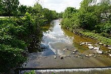
Four Mile Run is a 9.4-mile-long (15.1 km) stream in Northern Virginia that starts near Interstate 66, at Gordon Avenue in Fairfax County and proceeds southeast through Falls Church to Arlington County in the U.S. state of Virginia. Most of the stretch is parkland and is paralleled by two paved non-motorized transport and recreational trails, the Washington & Old Dominion Railroad Trail and the Four Mile Run Trail.
Contents
- Map of Four Mile Run United States
- History
- Tributaries
- Parks
- Trails
- Gunston Middle School Volunteerism
- References
Map of Four Mile Run, United States
In Arlington, the stream passes from the Piedmont through the fall line to the Atlantic Coastal Plain in a deep forested valley. The stream's eastern section forms the boundary of Arlington County and the City of Alexandria. The stream eventually empties out into the Potomac River immediately south of Reagan National Airport.
The name Four Mile Run does not derive from its length. A 2001 documentary film alleged that the name resulted from a misreading of an old map. The documentary stated that an old flour mill near the Potomac gave the stream the name of "Flour Mill Run", but the map had faded letters. A more plausible explanation is that the mouth of Four Mile Run is approximately four miles upriver from the mouth of Hunting Creek (sometimes called Great Hunting Creek) which is formed by the confluence of Cameron Run and Hooff's Run where they join the Potomac on the southern boundary of the City of Alexandria. Four Mile Run runs into the tidal Four Mile Creek within 1 mile (2 km) of the mouth of the stream.
History
During the colonial period and the 19th century, several watermills existed in and near the fall line of the stream. Although none of these mills remain intact, the foundation of one is still in place (Arlington Mill constructed in 1836; later rebuilt as Barcroft Mill in 1880 after being destroyed by Union Army troops during the Civil War). The mill provided locals with flour ground from corn and wheat that was grown locally and shipped up the stream on flatboats. Located west of the stream between Columbia Pike and 10th Street South in Arlington, the foundation presently supports an automobile repair shop.
General George Washington owned on the southwest side of the stream in the fall line a large parcel of wooded property which he surveyed in 1785, several years after the Revolutionary War ended. As part of this survey, Washington made a cut in the trunk of an oak tree to mark a corner of his property where a tributary (Long Branch (upper)) entered the main stream. A portion of this trunk remains preserved in a neighborhood library (Glencarlyn Library), while a columnar monument marks the tree's original location.
From about 1860 to 1968, the Washington and Old Dominion Railroad and its predecessors traveled along most of the stream's length in Arlington. The Northern Virginia Regional Park Authority's Washington and Old Dominion Railroad Trail now travels along the stream on the former railroad's route. In the late 19th century, a small resort at Carlin Springs became a favorite respite for Washingtonians who would ride the train out for bathing and dancing. Carlin Springs was located within the present day Glencarlyn Park, along Four Mile Run, and surrounding Glencarlyn Neighborhood.
From 1906 to 1915, the Luna Park amusement complex operated on the banks of Four Mile Run near its confluence with the Potomac. According to publicity, it was an "architecture fashion plate," featuring ballrooms, restaurants, roller coasters, shoot-the-chutes, circus performances, and exhilarating rides. Early residents frequently cooled off in the deeper pools of Four Mile Run, even though the water must have been polluted by sewage. Not until the 1930s did the county build a centralized sewage system, with a treatment plant on the site of the old Luna Park.
In June 1972, rains from Hurricane Agnes caused the stream to overflow its banks, producing extensive flooding which was especially severe in a populated area on the coastal plain. As a result of this event, the Army Corps of Engineers channelized the stream in this and other areas, covering the stream's natural banks with riprap.
Tributaries
Tributaries are listed in order from the source of Four Mile Run to its mouth.
Parks
The parks through or adjacent to which Four Mile Run flows, from the source of the stream to its mouth, are:
Trails
The paved trails that travel near Four Mile Run are:
Connecting trails are:
It is possible to bicycle or hike a triangle route that passes along all three of these trails.
Gunston Middle School Volunteerism
Gunston Middle School has been involved in protecting and exploring Four Mile Run actively since 2007. In cooperation with Arlingtonians for a Clean Environment [1] (ACE), Earth Force [2] students have participated in stream cleanups, dendrology, and invasive plants removal in Arlington county.