
 | ||
The Alps cover a large area. This article describes the delimitation of the Alps as a whole and of subdivisions of the range, follows the course of the main chain of the Alps and discusses the lakes and glaciers found in the region.
Contents
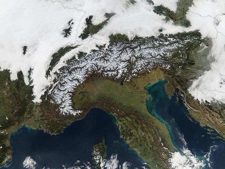
The Alps form a large mountain range dominating Central Europe, including parts of Italy, France, Switzerland, Liechtenstein, Austria, Slovenia, Germany and possibly Hungary (if one includes the Günser Gebirge or the Ödenburger Gebirge in the Alps). In some areas, such as the edge of the Po Basin, the edge of the range is unambiguous, but where the Alps border on other mountainous or hilly regions, the border may be harder to place. These neighbouring ranges include the Apennines, the Massif Central, the Jura, the Black Forest, the Böhmerwald, the Carpathians, and the mountains of the Balkan Peninsula.
The boundary between the Apennines and the Alps is usually taken to be the Colle di Cadibona, at 435 m above sea level, above Savona on the Italian coast.
The Rhône forms a clear boundary between the tectonically-formed Alps and the largely volcanically-formed Massif Central. Moving upstream, the Rhône turns to the east near Lyon, and passes to the south of the Jura range before reaching Lake Geneva. An area of flat ground reaches from there to Lake Neuchâtel, continuing the border, with the Jura to the north-west and the Alps to the south east. From Lake Neuchâtel to its confluence with the Rhine, the Aare forms the border.
The Black Forest is separated from the Alps by the Rhine and Lake Constance, but exact delimitation is difficult in southern Germany, where the land gently slopes up to meet the mountains (known in German as the Schwäbisch-Bayerisches Alpenvorland, the "Swabian-Bavarian pre-Alps").
In Austria, the Danube runs to the north of the Alps, separating it from the majority of the Böhmerwald, although some small areas, such as the Dunkelsteiner Wald south of the Wachau, belong geologically to the Böhmerwald despite being south of the Danube. The Wienerwald near Vienna forms the north-eastern corner of the Alps, and here the Danube passes at its closest to the Alps (see Viennese Basin).
East of Vienna, only the Marchfeld, a 30-km wide flood plain separates the easternmost Alps from the Lesser Carpathians. After Vienna, the Pannonian Basin, a large area of steppe, meets the edge of the Alps, clearly delimiting the eastern limit of the Alps.
The south-easternmost extension of the Alps is to be found in Slovenia, including Pohorje, the Kamnik Alps and the Julian Alps (the last being shared with Italy). The town of Idrija may be taken as marking the dividing line between the Alps to the north and the Karst plateau to the south, which then leads on to the mountains of the Balkan Peninsula.
The remainder of the southern edge of the Alps is clearly delimited by the basin of the Po.
This delimitation of the Alps is, however, largely subjective and open to argument. In particular, some people restrict the use of the term "Alps" to the higher mountains in the centre of the range, relegating the surrounding hills and mountains to the status of "pre-Alps" or foothills. This can sometimes lead to conflicting definitions, such as Mont Ventoux being considered to lie outside the Alps (there are no comparably sized mountains around it, and it is at a considerable distance from the main chain of the Alps).
It is also not possible to define the Alps geologically, since the same orogenous events that created the Alps also created neighbouring ranges such as the Carpathians. See also Geology of the Alps. The Alps are a distinct physiographic province of the larger Alpine System physiographic division, but the Alps are composed of three distinct physiographic sections, the Eastern, Western and Southern Alps physiographic sections.
Subdivisions
While smaller groups within the Alps may be easily defined by the passes on either side, defining larger units can be problematic. A traditional divide exists between the Western Alps and the Eastern Alps, which uses the Splügen Pass (Italian: Passo dello Spluga) on the Swiss-Italian border, together with the Rhine to the north and Lake Como in the south as the defining features. While the Splügen Pass is neither the lowest nor the most important pass in the Alps, it is approximately halfway along the main chain, and makes a convenient boundary.
Eastern Alps
The Eastern Alps are commonly subdivided according to the different lithology (rock composition) of the more central parts of the Alps and the groups at its northern and southern fringes:
The border between the Central Eastern Alps and the Southern Limestone Alps is the Periadriatic Seam. The Northern Limestone Alps are separated from the Central Eastern Alps by the Grauwacken Zone.
However, the geologic subdivision, based on tectonics, suggests a different system:
Western Alps
The Western Alps are commonly subdivided into the following:
Within the Eastern Alps, the most widely used subdivision is the Alpine Club's 1984 classification, which divides the region into about seventy small areas.
Main chain
The "main chain of the Alps" follows the watershed from the Mediterranean to the Wienerwald, passing over many of the highest and most famous peaks in the Alps. The most important passes and peaks which it crosses are given below (mountains are indented, passes unindented). From the Colle di Cadibona to Col de Tende it runs westwards, before turning to the north-west and then, near the Colle de la Maddalena, to the north. Upon reaching the Swiss border, the line of the main chain heads approximately east-north-east, a heading it follows until its end near Vienna.
Some of the highest peaks in the Alps, however, fall to one side or other of the main chain. These include:
For more detailed lists of passes, please see the articles about individual areas of the Alps.
Glaciers
Several glaciers are located in the Alps, the longest of which is the Aletsch Glacier in the Bernese Alps. They may be found in all of the higher groups of mountains from the Dauphiné Alps in France to the Hohe Tauern in central Austria, and the main ascent routes on many of the highest mountains pass over glaciers.
Lakes
Very few large lakes are found within the body of the Alps, but a number are situated around the edge, particularly in areas formerly covered by glacier tongues. These include Lake Geneva on the northern side of the alps, on the French/Swiss border, Lago Maggiore, Lake Como and Lake Garda on the southern side of the Alps in Italy, and the lakes of Switzerland, southern Germany and the Austrian Salzkammergut in the north.
Rivers
The main drainage basins of the Alps are those of the Rhine, the Rhone, the Danube and the Po. These have as main tributaries:
Other important rivers draining the Alps include the Var, Adige and Piave.
The triple watershed Rhine-Rhone-Po is south of Furka Pass near the summit of the Witenwasserenstock, at 46°31′N 8°27′E; the triple watershed Rhine-Po-Danube is at Lunghin Pass, Grisons (46°25′N 9°39′E, 2645 m); the triple watershed Po-Danube-Adige is at the Swiss-Italian border, near the summit of Monte Forcola south of Val Müstair, at 46°34′N 10°22′E.