
Peak Barre des Écrins Parent range Alps Highest point Barre des Écrins | Elevation 4,102 m (13,458 ft) | |
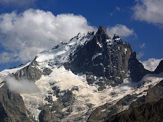 | ||
Borders on ListCottian AlpsGraian AlpsSavoy PrealpsDauphiné PrealpsProvence Alps and Prealps Mountains Barre des Écrins, Meije, Aiguilles d'Arves, Ailefroide, Mont Pelvoux | ||
The Dauphiné Alps (French: Alpes du Dauphiné) are a group of mountain ranges in southeastern France, west of the main chain of the Alps. Mountain ranges within the Dauphiné Alps include the Massif des Écrins (in the Parc national des Écrins), Belledonne, the Taillefer range and the mountains of Matheysine.
Contents
Etymology
The Dauphiné (pronounced: [dofine]) is a former French province whose area roughly corresponded to that of the present departments of Isère, Drôme, and Hautes-Alpes.
Geography
They are separated from the Cottian Alps in the east by the Col du Galibier and the upper Durance valley; from the western Graian Alps (Vanoise Massif) in the north-east by the river Arc; from the lower ranges Vercors Plateau and Chartreuse Mountains in the west by the rivers Drac and Isère. Many peaks rise to more than 10,000 feet (3,050 m), with Barre des Écrins (4,102 m) the highest.
Administratively the French part of the range belongs to the French departments of Isère, Hautes-Alpes and Savoie.
The whole range is drained by the Rhone river through its tributaries.
Peaks
The chief peaks of the Dauphiné Alps are:
Passes
The chief passes of the Dauphiné Alps are: