
Range Alps | Elevation 1,461 m | |
 | ||
Similar Alps, Aiguille des Grands Montets, Lac Blanc, Aiguilles Rouges, Col de la Forclaz | ||
Utmb 2015 xavier thevenard col des montets
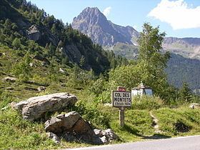
Col des Montets (elevation 1,461 m or 4,793 ft) is a mountain pass in the French Alps in the Haute-Savoie department of France. It is on the road between Chamonix, the Swiss Col de la Forclaz and Martigny in the canton of Valais, Switzerland.
Contents
- Utmb 2015 xavier thevenard col des montets
- Map of Col des Montets 74660 Vallorcine France
- Utmb 2016 images around col des montets
- References
Map of Col des Montets, 74660 Vallorcine, France
The pass is generally open in winter, but it can be closed in extreme weather and frequently requires snow chains and/or winter tires. Conditions can be checked with Chamonix tourist office. The pass appeared in the Tour de France five times from 1959 to 1977: Charly Gaul was the first rider to cross the pass in 1959.
Utmb 2016 images around col des montets
References
Col des Montets Wikipedia(Text) CC BY-SA