
Native name Monte Rosa | Elevation 4,634 m (15,203 ft) Translation Mount Glacier | |
 | ||
Listing Country high pointCanton high pointUltra Mountains Similar | ||
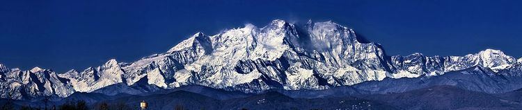
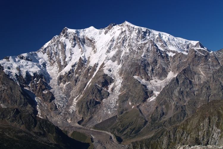
Monte rosa italy
The Monte Rosa (or synonymously used as a pleonasm: Monte Rosa massif (Italian: massiccio del Monte Rosa; German: Monte Rosa-Massiv; French: massif du Mont Rose) is a mountain massif located in the eastern part of the Pennine Alps. It is located between Switzerland (Valais) and Italy (Piedmont and Aosta Valley). Monte Rosa is the second highest mountain in the Alps and western Europe.
Contents
- Monte rosa italy
- Monte rosa ski aosta valley italy
- Etymology
- Geographic setting and description
- Geography
- Geology
- Climate
- Tourism
- Trekking
- Peaks
- Glaciers
- References
Monte Rosa is a huge ice-covered mountain in the Alps, located on the watershed between northern and southern Europe. Its main summit, named Dufourspitze in honor of the surveyor Guillaume-Henri Dufour, culminates at 4,634 m (15,203 ft) above sea level and is followed by the five nearly equally high subsidiary summits of Dunantspitze, Grenzgipfel, Nordend, Zumsteinspitze and Signalkuppe. Monte Rosa is the highest mountain of both Switzerland and the Pennine Alps and is also the second-highest mountain of the Alps and Europe outside the Caucasus. Monte Rosa covers the region on both side of the border between Switzerland and Italy, although its two main summits, unlike the four lower ones, lies on the Swiss side, within the canton of Valais.
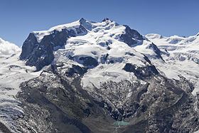
On the north-west side of the central Monte Rosa massif, with its enormous ice slopes and seracs, forms the boundary and upper basin of the large Gorner Glacier, which descends towards Zermatt and confluences with its nowadays much larger tributary, the Grenzgletscher (English: Border Glacier), right below the Monte Rosa Hut on the lower end of the visible western wing. The Grenzgletscher forms the impressive glacier between its western wing and Liskamm, a ridge on its southwestern side on the Swiss-Italian border. On the east side, in Italy, the mountain forms an almost vertical 2,400 metres (7,900 ft)-high wall of granite and ice, the biggest in Europe, overlooking Macugnaga and several smaller glaciers.
Monte Rosa was studied by pioneering geologists and explorers, including Leonardo da Vinci in the late fifteenth century and Horace-Bénédict de Saussure in the late eighteenth century. Following a long series of attempts beginning in the early nineteenth century, Monte Rosa's summit, then still called Höchste Spitze (English: Highest Peak), was first reached in 1855 from Zermatt by a party of eight climbers led by three guides. The great east wall was first climbed in 1872, from Macugnaga.
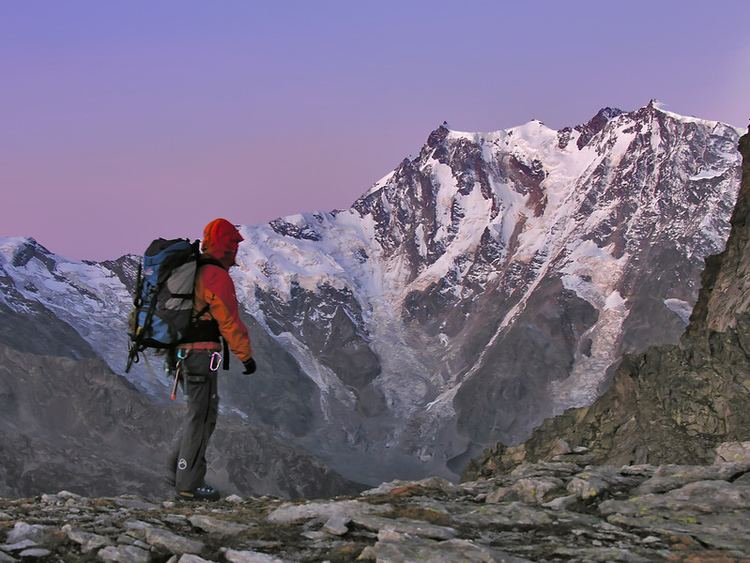
Each summer a large number of climbers set out from the Monte Rosa Hut on the mountain's west wing for one of its summits via the normal route or for the Margherita Hut on the Signalkuppe (Italian: Punta Gnifetti), used as a research station. Many tourists and hikers also come each year to the Gornergrat on the north-west side of the massif, to see the panorama that extends over the giants of the Alps, from Monte Rosa to the Matterhorn.
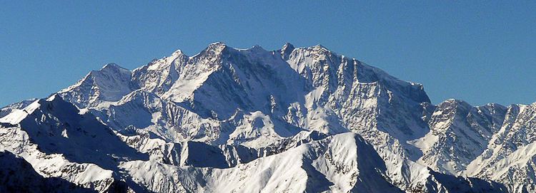
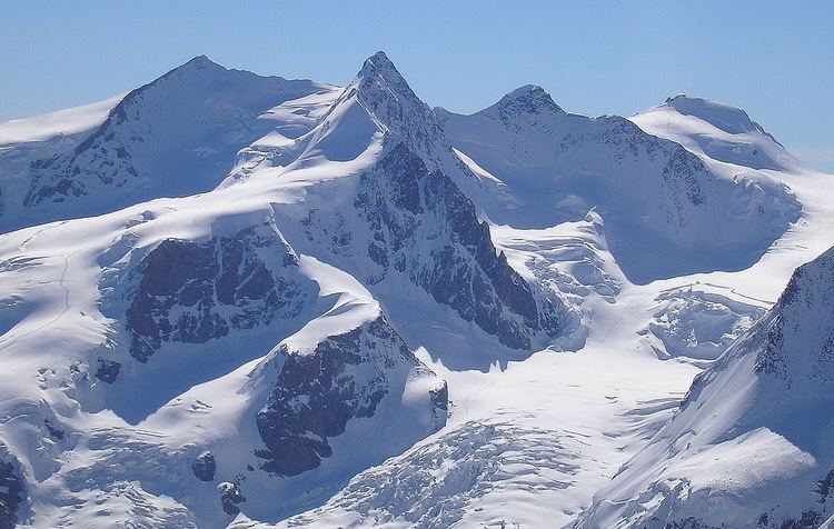
Monte rosa ski aosta valley italy
Etymology
Though Rosa as well as Rose mean "pink" in Italian and French respectively, the name is a false cognate derived from the Franco-Provençal Valdôtain patois word rouése meaning "glacier". On old maps as late as 1740, the mountain was named Monte Bosa and even Monte Biosa by the inhabitants of Val Sesia. The name Mon Boso which appears in Leonardo da Vinci's notebooks very likely designated the same mountain. From Zermatt the mountain was formerly known under the name Gornerhorn (in Walliser German, lit. Large/Strong Horn). The name gorner is still used for the western ridge that is thrown out from the main mass (Gornergrat) and the glacier that lies at its foot (Gornergletscher) but not used for the mountain itself anymore. Nowadays, in German, the Italian Monte Rosa is used instead (Monte Rosa-Gletscher, Monte Rosa-Hütte, etc.).
Geographic setting and description
Monte Rosa cover areas on both sides of the border between the Swiss canton of Valais and the Italian regions of Piedmont and Aosta Valley. The main summit of Monte Rosa, the Dufourspitze, however, is wholly Swiss and lies within the territory of the municipality of Zermatt, about 13 km (8.1 mi) south-east of the town centre and 3,000 m (9,800 ft) above it. The closest settlements are located on the Italian side of the massif: Macugnaga in the Valle Anzasca is located 9 km (5.6 mi) north-east of the summit while the villages of Alagna Valsesia in the Valsesia and Gressoney-La-Trinité in the Val de Gressoney are located 11 km (6.8 mi) south-east-south, and 13 km (8.1 mi) south-west-south, respectively, away from the summit. The different sides of the mountain greatly differ from each other. The Swiss west side is almost completely covered by large glaciers, tributaries of the 57 km2 (22 sq mi) large Gorner Glacier, descending progressively with gentle slopes and forming a large uninhabited glacial valley. The Italian east side consists of a 2,400 m (7,900 ft) high wall overlooking Macugnaga, whose snows feed the Belvedere Glacier at its base. The southeast face, culminating at the Signalkuppe, overlooks the piedmontese Valsesia (Italian: Valle della Sesia) and the Val de Gressoney in the autonomous region of Aosta Valley.
The mountain is mainly covered by eternal snows and glaciers, except for its summit which is a rocky ridge orientated west–east, near to and perpendicular to the main watershed between Switzerland and Italy (the river basins of the Rhône and the Po on the Swiss and Italian side, respectively). The connecting point between them is the Grenzgipfel (English: Border Summit) right on the border, and therefore also the highest peak on the Italian side. Thus Monte Rosa is the highest mountain in the Alps whose summit is not on the main alpine watershed, although it is off by only 150 metres. The Silbersattel (English: Silver Saddle) and Grenzsattel (English: Border Saddle) are the passes located north and south to the summit. The three main secondary summits of Monte Rosa are (from north to south): the Nordend (4,609 m; north of the Dufourspitze), the Zumsteinspitze (4,563 m; south of the Dufourspitze) and the Signalkuppe (4,554 m, Italian: Punta Gnifetti), all of them being positioned right on the Swiss-Italian border. Other secondary summits are the Parrotspitze (4,432 m), the Ludwigshöhe (4,341 m) and the Vincentpiramid (4,215 m). All of them originally have German names, since even the Italian valleys used to be by German-based Walsers inhabited valleys.
Several perpendicular secondary ridges are connected to the central massif dividing the glaciers that descend towards the Matter Valley. The ridge called Weissgrat connecting the Nordend with the Schwarzberghorn (Italian: Corno Nero) presents a wall of formidable precipices towards the east, but falls away in a gentle slope to the west. For a breadth of a few kilometres the upper snow-fields of the Weissgrat lie almost unbroken upon this slope, but as they begin to descend towards the Matter Valley they are divided into two icestreams (the upper Gorner Glacier and the Findel Glacier) by a ridge which gradually emerges from the névé, and finally presents a rather bold front to the glaciers on either side. The highest points of this ridge, appearing insignificant by contrast with the grand objects around, is the Stockhorn (3,532 m)) and the lower Gornergrat at 3,090 m. On their south sides is the lower Gorner Glacier, formed by the confluence of all the major (Gornergletscher and Grenzgletscher) and minor tributaries descending from the north, west and south sides of the central Monte Rosa massif, while on the north side the Findel Glacier descends near to the hamlet of Findeln.
Monte Rosa is one of the high mountains surrounding the 40 km (25 mi) long Matter Valley south of Stalden. On the southwest to west are Liskamm, Zwillinge with Castor and Pollux, the Breithorn and the Matterhorn; on the north are the Weisshorn and the Dom. The Gornergrat summit, lying 8 km (5.0 mi) on the north-west at 3,100 metres (10,200 ft), is a popular view point of the massif, since it is accessible by train from Zermatt, using the highest open air railway line in Europe.
Geography
The extended range of Monte Rosa, which appears to originate in the intersection of two axes of great elevation, throws out a number of ridges that radiate afar and gradually subside into the plain of northern Italy, covering a relatively large area. There are no convenient mode of subdividing the range. However the natural limits of the district can be defined on the north side by the two branches of the Visp torrent. Following the west branch through the Mattertal, crossing the Theodul Pass, descending by the Valtournanche to Châtillon and to Ivrea, and passing round the base of the mountains by Arona, along Lake Maggiore, and up the valley of the Toce, to Vogogna, then ascending by the Val Anzasca to the Monte Moro Pass, the circuit is completed by the descent through the Saastal to Stalden. Within the line so traced, exceeding 450 km in length, all the ranges properly belonging to this group are included.
The direction of the ranges and the depressions offers a marked contrast to that prevailing throughout the adjoining regions of the Alps. Unless in a small part of the Italian valleys, the direction here is either parallel or perpendicular to the meridian. Monte Rosa itself lies near the intersection of a great north and south ridge, extending from the Balfrin through the Mischabelhörner, and the highest peaks of the mountain itself, to the Vincent Pyramide, and thence through the range that bounds the Valle di Gressoney, nearly to Ivrea, with the transverse range lying between the Dent d'Herens and the Pizzo Bianco near Macugnaga. The minor ridges on the north side of the border are parallel to this latter range, with their corresponding depressions occupied by the glaciers of Gorner and Findelen.
On clear days the mountainous massif of Monte Rosa provides a striking view from the Po plain, particularly its upper reaches in western Lombardy and eastern Piedmont. It dominates the horizon, towering between other lesser Alpine peaks as a prominent, multi-pointed, razor-sharp bulge, its permanent glaciers shining under the sun.
"It is the opinion of many of the most competent judges, that for grandeur, beauty, and variety, the valleys descending from Monte Rosa are entitled to preeminence over every other portion of the Alps, and perhaps, if we regard the union of those three elements, over every other mountain region in the world." - John Ball (first president of the Alpine Club)The massif is the border between Switzerland and Italy, though glacial melt has caused some alterations to the border. These changes were ratified by the two countries in 2009 and will continue to be subject to change as melting continues.
Geology
The entire massif consists mainly of granite and granite gneiss (a metamorphic rock with foliations). The Monte Rosa Nappe lies below the Zermatt-Saas zone and is part of the Penninic nappes in the Briançonnais microcontinent zone, although its paleographic origin is controversial and is sometimes assigned to the Sub-Penninic nappes. Rocks in the paragneiss of the Monte Rosa Nappe record eclogite-facies metamorphism. The deformation of the Monte Rosa granites indicates a depth of subduction of about 60 km. They were brought to the surface by tectonic uplift, which still continues today.
The summit is a sharp, jagged edge of mica schist connected by an arête with the Nordend, but cut off from the Zumsteinspitze to the south by nearly vertical rocks about 120 m (390 ft) in height.
Climate
Being the highest point in Switzerland, Monte Rosa is also one of the most extreme places. The average air pressure is about half of that of the sea level (56%) and the temperature can reach as low as −40 °C (−40 °F). Owing to the frequent prevalence of a high wind from the east or north-east, and the slow pace at which it is possible to move when near the top, precautions against cold are particularly requisite when climbing Monte Rosa. The snow line is located at about 3,000 metres.
Tourism
The Monte Rosa massif is popular for mountaineering, hiking, skiing and snowboarding. It hosts several ski resorts with long pistes. Plateau Rosa, about 3,500 metres high above sea level, is a renowned summer ski resort, with permanent snow all year round due to the altitude. The Plateau Rosa is connected via aerial tramway to Cervinia and to Zermatt via the Klein Matterhorn. The western fringes of the massif reach the Zermatt ski domain. Gressoney, Champoluc, Alagna Valsesia and Macugnaga (under the impressive east face, intensely glaciated and some 2,500 metres high) are the main mountain and ski resorts that surround Monte Rosa along its southern side. Monte Rosa is not technically difficult to climb in itself, despite hosting some quite impressive ridges, but can be quite dangerous due to its great altitude and sudden weather changes, as well as crevasses in its extensive glaciers - one of the major glaciated areas in the Alps.
Trekking
The Tour of Monte Rosa can be effected by trekkers in about 10 days. The circuit follows many ancient trails that have linked the Swiss and Italian valleys for centuries. The circuit includes larch forests, alpine meadows, balcony trails and a glacial crossing. It connects seven valleys embracing different cultures: the German speaking high Valais, the Arpitan speaking Aosta Valley and the valleys of Lombardy and Piedmont. Good conditions are necessary to circumnavigate the massif. After reaching Saint-Jacques by the Theodul Pass and the Col des Cimes Blanches, the trekker crosses the Bettaforca Pass before arriving at Gressoney-La-Trinité. Then two passes must be crossed on the road to Macugnaga, the Col d'Olen and the Colle del Turlo. From Macugnaga the trekker reaches the Saastal by the Monte Moro Pass and goes around the Mischabelhörner before ending his journey in Zermatt. In total six passes between 2700 and 3300 metres must be crossed on a relatively difficult terrain.
Peaks
Usually these peaks are considered to be part of the Monte Rosa massif:
Glaciers
Usually these glaciers are considered to be part of the Monte Rosa massif: