
Elevation 3,553 m (11,657 ft) | ||
 | ||
Canton, Region ListValaisTicinoGraubündenUriPiedmontLombardy Borders on ListPennine AlpsBernese AlpsUri AlpsGlarus AlpsWestern Rhaetian AlpsLugano Prealps Mountains Similar Alps, Pennine Alps, Monte Leone, Rhaetian Alps, Rheinwaldhorn | ||
The Lepontine Alps (German: Lepontinische Alpen, French: Alpes lépontines, Italian: Alpi Lepontine) are a mountain range in the north-western part of the Alps. They are located in Switzerland (Valais, Ticino, Uri and Graubünden) and Italy (Piedmont and Lombardy).
Contents
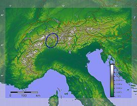
- Map of Lepontine Alps 6696 Lavizzara Switzerland
- EtymologyEdit
- GeographyEdit
- List of peaksEdit
- GlaciersEdit
- List of passesEdit
- References
Map of Lepontine Alps, 6696 Lavizzara, Switzerland
The Simplon rail tunnel (from Brig to Domodossola) the Gotthard rail (from Erstfeld to Bodio) and Gotthard road tunnels (from Andermatt to Airolo) and the San Bernardino road tunnel are important transport arteries.
The eastern portion of the Lepontine Alps, from the St Gotthard Pass to the Splügen Pass, is sometimes named the Adula Alps.
EtymologyEdit
The designation Lepontine Alps, derived from the Latin name of the Val Leventina, has long been somewhat vaguely applied to the Alpine ranges that enclose it, before being used for the whole range.
GeographyEdit
Following the line marking the division of the waters that flow into the Po from those that feed the Rhone or the Rhine, the main ridge of the Lepontine Alps describes a somewhat irregular curve, convex to the north, from the Simplon Pass to the Splugen Pass. With the single exception of the Monte Leone, overlooking the pass of the Simplon, the summits of this portion of the chain are much inferior in height to those of the neighbouring chains; but two peaks of the Adula group, culminating at the Rheinwaldhorn, exceed 11,000 feet (3,400 m) in height.
The extensive region lying south of the main ridge is occupied by mountain ranges whose summits sometimes rival in height those of the dividing ridge, and which are cut through by deep valleys, three of which converge in the basins of Lake Maggiore and Lake Como, the deepest of all the lakes on the south side of the Alps. The most important of these valleys is the Val Leventina, or the Upper valley of the Ticino. This has been known from a remote antiquity because it leads to the Pass of St Gotthard, one of the easiest lines of communication between northern and southern Europe.
The Lepontine Alps are drained by the rivers Rhône in the west, Reuss in the north, Rhine (Vorderrhein and Hinterrhein) in the east and Ticino and Toce in the south.
List of peaksEdit
The chief peaks of the Lepontine Alps are:
GlaciersEdit
Main glaciers :
List of passesEdit
The chief passes of the Lepontine Alps are: