
Prominence 118 m (387 ft) Parent range Lepontine Alps | Elevation 3,082 m | |
 | ||
Similar Pizzo Rotondo, Chüebodenhorn, Pizzo Lucendro, Muttenhorn, Pizzo Gallina | ||
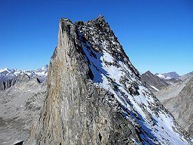
The Witenwasserenstock (3,082 m) is a peak between the Swiss cantons of Valais and Uri, located in the Lepontine Alps. Close to the summit lies the tripoint border between the cantons of Valais, Uri and Ticino and the triple watershed of the Rhine, Po and Rhône basins.
Contents
Map of Witenwasserenstock, 3999 Realp, Switzerland
Geography and hydrographyEdit
The Witenwasserenstock lies between the valleys of Geretal (west) and Witenwasseren (north-east). At the foot of the mountain are located the Geren and Witenwasseren Glaciers. The tripoint between the cantons of Valais, Uri and Ticino (3,025 m) is located 300 m east from the summit. It acts as a notable watershed. On the west the Gerenwasser ends in the young Rhone, on the east the Witenwasserenreuss ends in the Reuss, a tributary of the Rhine and, on the east, the Ri di Bedretto ends in the Ticino (in the Leventina), a tributary of the Po.