
State Western Australia Electors 26,192 (2017) | Party National (notional) | |
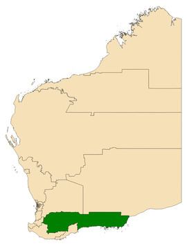 | ||
Dates current 1950–1983; 1989–2008; 2017–present Area 106,409 km (41,084.7 sq mi) Demographic Electoral region of Agricultural | ||
Roe is an electoral district of the Legislative Assembly of Western Australia. It takes in rural areas in the south of the state. Roe was re-created for the 2017 state election, having previously been in existence from 1950 to 1983 and from 1989 to 2008. It has a notional 16.7-point majority for the National Party against the Liberal Party, based on the results of the 2013 state election.
Contents
Geography
In its current incarnation, Roe includes portions of four regions of Western Australia – the South West, the Wheatbelt, the Great Southern, and Goldfields-Esperance. There are eighteen local government areas that fall into the district: Broomehill-Tambellup, Cranbrook, Cuballing, Dumbleyung, Esperance, Gnowangerup, Katanning, Kent, Kojonup, Kulin, Lake Grace, Narrogin, Ravensthorpe, Wagin, West Arthur, Wickepin, Williams, and Woodanilling.
History
Roe was abolished ahead of the 2008 state election as a result of the reduction in rural seats made necessary by the one vote one value reforms. At its abolition in 2008, Roe was a southern coastal electorate that included the towns of Esperance, Gnowangerup, Kulin, Lake Grace, Bremer Bay and Ravensthorpe. Its former territory was split between the new district of Eyre and the enlarged district of Wagin. Following Roe's abolition, sitting Liberal MP Graham Jacobs contested and won the seat of Eyre.
Roe was re-created in a redistribution prior to the 2017 state election, taking in areas of two abolished seats, Eyre and Wagin.