
 | ||
The various regions of Western Australia are determined by a number of systems that divide Western Australia into distinct geographic "regions" for a variety of purposes.
Contents
- The Regional Development Commissions Act regions
- Bureau of Meteorology BOM regions
- Political regions
- State government departmental regions
- Natural and land management
- Land tenure
- Wine regions
- Census and Australian Bureau of Statistics
- Cross regional terminology
- Maps
- References
The most common system is the W.A. Government division of the state into regions for economic development purposes, which comprises nine defined regions; however, there are a number of other systems, including those made for purposes of land management (such as agriculture and conservation), information gathering (such as statistical and meteorological), and election for political office.
The various different systems were defined for different purposes, and give specific boundaries, but although many of the different systems' regions have similar names, they have different boundaries; the names and boundaries of regions can and do vary between systems.
The Regional Development Commissions Act regions
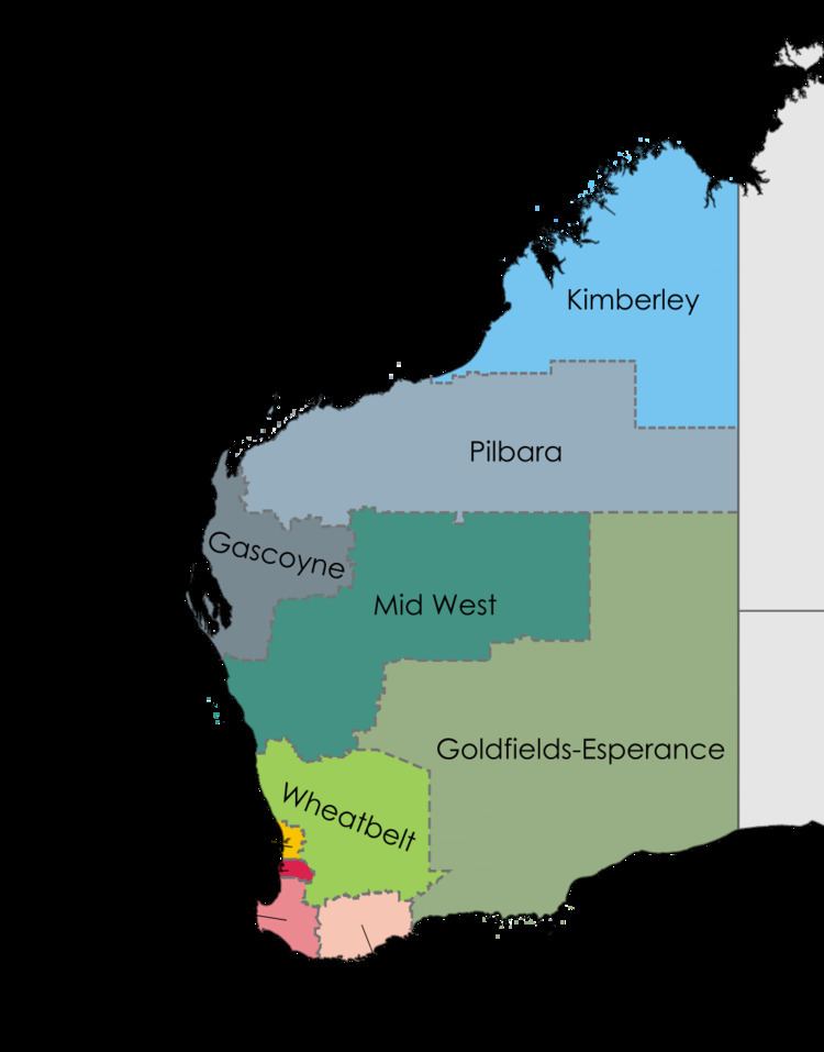
The Western Australian system of regions defined by the Government of Western Australia for purposes of economic development administration, which excludes the Perth metropolitan area, is a series of nine regions.
These nine regions were established by the Regional Development Commissions Act 1993, which defined their extents and established Regional Development Commissions to promote their economic development. In defining the regions, an attempt was made to capture distinct socio-economic communities. For example, the Goldfields-Esperance region of Western Australia has an economy based heavily on mining, whereas the Wheatbelt region is economically dependent on agriculture.
The nine defined regions are:
Bureau of Meteorology (BOM) regions
The same region names as those used by the Regional Development Commissions Act (RDCA) are incorporated into the system used by BOM, which uses 14 regions, so the boundaries of the two systems do not coincide. In some of the regions, the BOM designates the forecast area regions with a finer level of detail using points of the compass. Regions numbered 8 to 14 are usually known as forecast areas in the South West Land Division; coastal zones for sea forecasts are dealt with in Coastal regions of Western Australia.
Political regions
Under Australia's three-tiered system of government, Western Australia has four political regional schemes:
State government departmental regions
Many government departments maintain systems of regional and district breakdowns of the state for their own internal purposes.
Fisheries tends to separate the state into four main regions for the purpose of regulating recreational fishing:
The Department produces statistical data based on the Regional Development Commissions Act regionalisation schema
Since the creation of the Department of Industry and Resources some rationalisation of mines administration has occurred, however the mineral fields and boundaries remain the same as when established.
There are three regions with regional planning schemes, covering only a small part of the state:
Natural and land management
See also Category:Biogeography of Western Australia
There are a number of regionalisations that attempt to provide a regionalisation based on natural features. The best known of these are the Interim Biogeographic Regionalisation for Australia (IBRA) regions, and the World Wildlife Fund's Ecoregions in Australia, and the "natural regions" of John Stanley Beard, all of which are based on biogeography. Other natural regionalisations included the drainage basins and catchments of river systems, and highly specialised regionalisations dealing with such matters as geology and soil systems.
Administrative regionalisations include Landcare Districts and the Department of Agriculture's "Land-use Zones". However the Department of Agriculture publications - Technical Bulletins - usually titled An inventory and condition report/survey... of a particular region are very specifically focused upon land systems that are based on natural features.
Land tenure
Western Australia is divided into approximately 90 land districts for cadastral purposes. There are five land divisions in Western Australia, as specified in Schedule 1 of the Land Administration Act 1997.
Wine regions
Australia’s biggest State extends the western third of the continent, although the winemaking regions are almost entirely situated in the south-western tip of the State. It has nine regions, and five nominated subregions for wine under the Geographical indications legislation as determined by the Australian Wine and Brandy Corporation.
Wine regions include:
Western Australia has the longest coastline of any state in Australia, at 10,194 km. The regions can be determined by the underlying geology, and in the case of the Bureau of Meteorology - features such as points and capes are useful indicators of coastal water forecasts.
Landgate publishes touring maps that include coastal zones including:
Census and Australian Bureau of Statistics
For the purposes of statistical geography, the Australian Bureau of Statistics uses the Australian Standard Geographical Classification, a hierarchical regionalisation that divides Western Australia into statistical divisions, then statistical subdivisions, statistical local areas, and finally, census collection districts.
Statistical Divisions include:
The ABS produces Regional profiles for the nine ABS Statistical Divisions, and the ten Development Commission regions.
Cross-regional terminology
In some cases, regions have been grouped into larger areas, to describe a larger area in a single term: