
Length 30 km (19 mi) Elevation 1,700 m | Width 8 km (5.0 mi) | |
 | ||
Mountains | ||
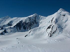
Tangra Mountains (in Bulgarian Тангра планина, 'Tangra planina' \'tan-gra pla-ni-'na) (62°40′00″S 60°06′00″W) form the principal mountain range of Livingston Island in the South Shetland Islands, Antarctica. The range had been nameless until 2001, when it was named after the Bulgar god Tangra.
Contents
Tangra Mountains are 30 km long between Barnard Point and Renier Point, 8 km wide, and are bounded by Moon Bay and Huron Glacier to the north, Huntress Glacier to the northwest, False Bay to the west, and Bransfield Strait to the southeast, and is linked to Bowles Ridge by Wörner Gap, and to Pliska Ridge by Nesebar Gap. The mountain is divided in three principal ridges: Friesland Ridge in the west, Levski Ridge in the centre, and Delchev Ridge in the east.
The peaks and slopes of Tangra are heavily glaciated, and drained by the glaciers Huron, Huntress, Ruen Icefall, Peshtera, Charity, Tarnovo Ice Piedmont, Prespa, Macy, Boyana, Srebarna, Magura, Dobrudzha, Ropotamo, Strandzha, Pautalia, Sopot Ice Piedmont, and Iskar.
Camp Academia in the northwestern foothills of Zograf Peak is the perfect gateway to central Tangra Mountains via Catalunyan Saddle (1260 m) to the south and Lozen Saddle (437 m) to the east. Catalunyan Saddle was occupied by a bivouac of the Tangra 2004/05 Exploration team on 14–16 December 2004.
Friesland Ridge
Friesland Ridge is 15.5 km long from Botev Point in the southwest to Shipka Saddle to the northeast. The summit Mount Friesland (62°40′14.9″S 60°11′10.7″W) rises to exactly 1700 m. It was accurately measured by GPS in December 2003 by the Omega Foundation expedition led by Damien Gildea, which made the second ascent of Mount Friesland. Other main peaks are St. Boris (1699 m), Simeon (1580 m), St. Cyril (1505 m), Lyaskovets (1473 m), Presian Ridge (1456 m), St. Methodius (1180 m), Academia (1253 m), and Zograf (1011 m). First ascents: Mount Friesland by Francesc Sàbat and Jorge Enrique from Juan Carlos I Base on 30 December 1991; Lyaskovets Peak by L. Ivanov and D. Vasilev from Camp Academia on 14 December 2004; Zograf Peak by L. Ivanov from Camp Academia on 31 December 2004; and St. Boris Peak by D. Boyanov and N. Petkov from Camp Academia area on 23 January 2016.
Levski Ridge
Levski Ridge is 8 km long between Shipka Saddle to the west and Devin Saddle to the east, and 8 km wide between Cherepish Ridge to the north and Christoff Cliff to the south. The summit Great Needle Peak (62°40′15″S 60°03′10″W) rises to 1680 m, and was first ascended and GPS-surveyed by the Bulgarian mountaineers Doychin Boyanov, Nikolay Petkov and Aleksander Shopov on 8 January 2015. Other main peaks are Levski (1430 m), St. Ivan Rilski Col (1350 m), Helmet (1254 m), Serdica (1200 m), Vihren (1150 m), Ongal (1149 m), and Plovdiv (1040 m). Other first ascents: Ongal Peak and Komini Peak (774 m) by L. Ivanov from Camp Academia on 21 December 2004, and Plana Peak by D. Boyanov, N. Petkov and A. Shopov on 8 January 2015.
Delchev Ridge
Delchev Ridge is 10 km long between Devin Saddle to the west and Renier Point to the east. The summit Delchev Peak (62°38′28″S 59°56′16″W) rises to 940 m, other main peaks are Ruse (800 m), Asen (800 m), Peter (800 m), Kuber (770 m), Elena (700 m), Spartacus (650 m), Yavorov (640 m), and Paisiy (550 m).
Mapping
British mapping of the mountains in 1968, Spanish mapping in 1991, Omega Foundation mapping in 2004, Bulgarian mapping in 2005 and 2009 from topographic surveys in 1995/96 and 2004/05.