Suvarna Garge (Editor)

St. Cyril Peak

Updated on
Edit
Like
Comment
Share on FacebookTweet on TwitterShare on LinkedInShare on Reddit
First ascent
  
unclimbed

Mountain range
  
Elevation
  
1,505 m

Parent range
  
St. Cyril Peak httpsuploadwikimediaorgwikipediacommonsthu

People also search for
  
Simeon Peak, Mount Friesland, Deception Island

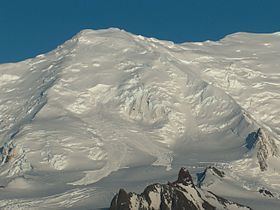
St. Cyril Peak (Vrah Sv. Kiril \'vr&h sve-'ti 'ki-ril) rises to 1,505m in Friesland Ridge in Tangra Mountains on Livingston Island in the South Shetland Islands, Antarctica. The peak is linked to St. Methodius Peak to the southwest by Vladaya Saddle and surmounts Ruen Icefall to the west, Macy Glacier to the east and Prespa Glacier to the south.

Contents

Map of St. Cyril Peak, Antarctica

The peak is "named after St. Cyril (827-869 AD) who, together with St. Methodius, created the Glagolitic alphabet and translated the Holy Books into Bulgarian language".

Location

The peak is located at 62°42′20″S 60°12′50″W, which is 4.15 km south-southwest of Mount Friesland, 1.69 km south of Simeon Peak, 4.27 km northwest of Samuel Point, 1.97 km northeast of St. Methodius Peak and 6.79 km southeast of Napier Peak (Bulgarian topographic survey in 1995/96, and mapping in 2005 and 2009).

Maps

  • South Shetland Islands. Scale 1:200000 topographic map No. 3373. DOS 610 – W 62 58. Tolworth, UK, 1968.
  • Islas Livingston y Decepción. Mapa topográfico a escala 1:100000. Madrid: Servicio Geográfico del Ejército, 1991.
  • S. Soccol, D. Gildea and J. Bath. Livingston Island, Antarctica. Scale 1:100000 satellite map. The Omega Foundation, USA, 2004.
  • L.L. Ivanov et al., Antarctica: Livingston Island and Greenwich Island, South Shetland Islands (from English Strait to Morton Strait, with illustrations and ice-cover distribution), 1:100000 scale topographic map, Antarctic Place-names Commission of Bulgaria, Sofia, 2005
  • L.L. Ivanov. Antarctica: Livingston Island and Greenwich, Robert, Snow and Smith Islands. Scale 1:120000 topographic map. Troyan: Manfred Wörner Foundation, 2010. ISBN 978-954-92032-9-5 (First edition 2009. ISBN 978-954-92032-6-4)
  • Antarctic Digital Database (ADD). Scale 1:250000 topographic map of Antarctica. Scientific Committee on Antarctic Research (SCAR), 1993–2016.
  • References

    St. Cyril Peak Wikipedia


    Similar Topics