
Elevation 1,665 m | ||
 | ||
First ascent 23 December 2016 Doychin Boyanov and Nikolay Petkov People also search for Mount Friesland, Lyaskovets Peak, Deception Island | ||
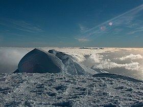
St. Boris Peak (Vrah Sv. Boris \'vr&h sve-'ti bo-'ris) is an ice-covered mountain rising to 1,698 m in Friesland Ridge, Tangra Mountains on Livingston Island in the South Shetland Islands, Antarctica. It is the second highest peak of both the mountains and the island after Mount Friesland (1,700.2 m). The two are connected by a short saddle dominated by ‘The Synagogue’, a sharp-peaked rock-cored ice formation abutting upon St. Boris Peak. The peak is also connected to Simeon Peak by Paril Saddle, and surmounts Huntress Glacier to the northwest and west, and Macy Glacier to the southeast. The peak's central summit is rising to 1,685 m, while its highest point ‘The Synagogue’ rises to 1,698 m. The local ice relief is subject to change; according to a Bulgarian GPS survey by D. Boyanov and N. Petkov the elevation of Mt. Friesland was 1,693 m in December 2016, making St. Boris Peak the summit of Tangra Mountains and the island in that season.
Contents
Map of St. Boris Peak, Antarctica
The peak was first ascended and GPS surveyed by the Bulgarians D. Boyanov and N. Petkov from Camp Academia area via Mount Friesland on 23 December 2016. A different route was followed by the same climbers and N. Hazarbasanov on 16 January 2017, namely from Nesebar Gap via upper Huntress Glacier and Academia Peak.
The feature is named after Czar St. Boris I of Bulgaria, 852-889 AD.
Location
The central summit of the mountain is located at 62°40′32″S 60°11′33″W, which is 650 m south-southwest of Mount Friesland, 4.34 km northwest of Peshev Peak, 1.86 km north-northeast of Simeon Peak, 4.89 km southeast of Willan Nunatak and 3.85 km south-southeast of the summit of Pliska Ridge (Bulgarian topographic survey in 1995/96, and mapping in 1996, 2005 and 2009).