
Location Antarctica Elevation 2,300 m Peak Mount Irving | Highest elevation 2,300 m (7,500 ft) Population around 500 Area 3,687 km² | |
 | ||
Points of interest Hektor Whaling Station, Mount Pond Islands | ||
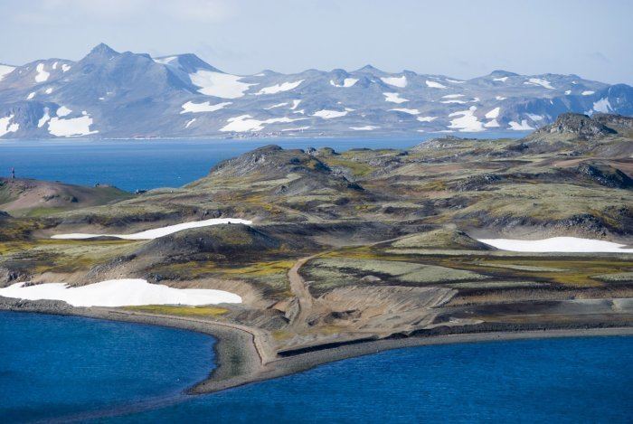
Pendulum cove deception island south shetland islands antarctic peninsula antarctica south pole
The South Shetland Islands are a group of Antarctic islands, lying about 120 kilometres (75 mi) north of the Antarctic Peninsula, with a total area of 3,687 square kilometres (1,424 sq mi). By the Antarctic Treaty of 1959, the islands' sovereignty is neither recognized nor disputed by the signatories and they are free for use by any signatory for non-military purposes.
Contents
- Pendulum cove deception island south shetland islands antarctic peninsula antarctica south pole
- Map of South Shetland Islands Antarctica
- History
- Geography
- Climate
- Flora and fauna
- Diptera
- Islands
- Research stations
- Field camps
- Maps
- References
Map of South Shetland Islands, Antarctica
The islands have been claimed by the United Kingdom since 1908 and have been part of the British Antarctic Territory since 1962. They are also claimed by the governments of Chile (since 1940, as part of the Antártica Chilena province) and by Argentina (since 1943, as part of Argentine Antarctica, Tierra del Fuego Province).
Several countries maintain research stations on the islands. Most of them are situated on King George Island, benefitting from the airfield of the Chilean base Eduardo Frei.
There are sixteen research stations to date in different parts of the islands, with Chilean stations being the greatest in number. Research is often a shared duty of nations, with the Chilean-United States Shirreff Base being one example.
History
Chilean scientists have claimed that Amerind visited the islands, due to stone artifacts recovered from bottom-sampling operations in Admiralty Bay, King George Island and Discovery Bay, Greenwich Island; however, the artifacts — two arrowheads — were later found to have been planted. The Dutchman Dirck Gerritsz in 1599, or the Spaniard Gabriel de Castilla in 1603, supposedly sailed south of the Drake Passage in the South Shetland Islands area. In 1818 Juan Pedro de Aguirre obtained permission from the Buenos Aires authorities to establish a base for sealing on "some of the uninhabited islands near the South Pole".
Captain William Smith in the British merchant brig Williams, while sailing to Valparaíso, Chile in 1819 deviated from his route south of Cape Horn, and on 19 February sighted Williams Point, the northeast extremity of Livingston Island. Thus Livingston Island became the first land ever discovered south of the 60th southern latitude. Smith revisited the South Shetlands, landed on King George Island on 16 October 1819, and claimed possession for Britain.
Meanwhile, the Spanish Navy ship San Telmo sank in September 1819 whilst trying to go through the Drake Passage. Parts of her presumed wreckage were found months later by sealers on the north coast of Livingston Island.
From December 1819 to January 1820, the islands were surveyed and mapped by Lieutenant Edward Bransfield on board the Williams, which had been chartered by the Royal Navy.
On 15 November 1819 the United States agent in Valparaíso, Jeremy Robinson, informed the US Secretary of State John Quincy Adams of Smith's discovery and Bransfield's forthcoming mission, and suggested dispatching a US Navy ship to explore the islands where "new sources of wealth, power and happiness would be disclosed and science itself be benefited thereby."
The discovery of the islands attracted British and American sealers. The first sealing ship to operate in the area was the brig Espirito Santo, chartered by British merchants in Buenos Aires. The ship arrived at Rugged Island off Livingston Island, where its British crew landed on Christmas Day 1819, and claimed the islands for King George III. A narrative of the events was published by the brig's master, Joseph Herring, in the July 1820 edition of the Imperial Magazine. The Espirito Santo was followed from the Falkland Islands by the American brig Hersilia, commanded by Captain James Sheffield (with second mate Nathaniel Palmer), the first US sealer in the South Shetlands.
The first overwintering in Antarctica took place on the South Shetlands, when at the end of the 1820–21 summer season eleven British men from the ship Lord Melville failed to leave King George Island, and survived successfully to be rescued at the beginning of the next season.
Having circumnavigated the Antarctic continent, the Russian Antarctic expedition of Fabian von Bellingshausen and Mikhail Lazarev arrived at the South Shetlands in January 1821. The Russians surveyed the islands and named them, landing on both King George Island and Elephant Island. While sailing between Deception and Livingston islands, Bellingshausen was visited by Nathaniel Palmer, master of the American brig Hero, who informed him of the activities of dozens of American and British sealing ships in the area.
The name "New South Britain" was used briefly, but was soon changed to South Shetland Islands (in reference to the Shetland Islands off the northern coast of Scotland). The name South Shetland Islands is now established in international usage. Both island groups lie at a similar distance from the South Pole and North Pole respectively, but the South Shetlands are much colder (see below).
Seal hunting and whaling was conducted on the islands during the 19th and early 20th century. From 1908 the islands were governed as part of the Falkland Islands Dependency, but they have only been occupied since the establishment of a scientific research station in 1944. The archipelago, together with the nearby Antarctic Peninsula and South Georgia, is an increasingly popular tourist destination during the austral summer.
Geography
As a group of islands, the South Shetland Islands are located at 62°0′S 58°0′W. They are within the region 61° 00'–63° 37' South, 53° 83'–62° 83' West. The islands lie 940 km (580 mi) south of the Falkland Islands, and between 93 km (58 mi) (Deception Island) and 269 km (167 mi) (Clarence Island) northwest and north from the nearest point of the Antarctic continent, Graham Land.
The South Shetlands consist of 11 major islands and several minor ones, totalling 3,687 square kilometres (1,424 sq mi) of land area. Between 80 and 90 percent of the land area is permanently glaciated. The highest point on the island chain is Mount Irving on Clarence Island at 2,300 metres (7,546 ft) above sea level.
The South Shetland Islands extend about 450 km (280 mi) from Smith Island and Low Island in the west-southwest to Elephant Island and Clarence Island in the east-northeast.
Climate
The islands are the same distance from the equator as the Faroe Islands in the North Atlantic, but their proximity to Antarctica means that they have a much colder climate. The sea around the islands is closed by ice from early April to early December and the monthly average temperature is below 0 °C (32 °F) for eight months of the year (April to November).
The islands have experienced measurable glacier retreat during recent years, but despite this, they remain more than 80% snow and ice covered throughout the summer.
The climate is cloudy and humid all year round and very strong westerly winds blow at all seasons. Some of the sunniest weather is associated with outbreaks of very cold weather from the south in late winter and spring. Mean summer temperatures are only about 1.5 °C (34.7 °F) and those in winter are about −5 °C (23 °F). The effect of the ocean tends to keep summer temperatures low and winter temperatures from decreasing as low as they do inland to the south.
Flora and fauna
Despite the harsh conditions the islands do support vegetation and are part of the Scotia Sea Islands tundra ecoregion, along with South Georgia and the South Sandwich Islands, the South Orkney Islands and Bouvet Island. All these islands lie in the cold seas below the Antarctic Convergence. These areas support tundra vegetation consisting of mosses, lichens and algae, while seabirds, penguins and seals feed in the surrounding waters.
Diptera
Islands
From north to south the main and some minor islands of the South Shetlands are:
(The Russian names above are historical, and no longer the official Russian names of the relevant islands. See the end of the article for a complete list of minor islands.)
Research stations
Several nations maintain research stations on the Islands: