
 | ||
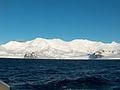
Friesland Ridge (Hrebet Frisland \'hre-bet 'fris-land) is a ridge on Livingston Island in the South Shetlands, part of the Tangra Mountains. The summit, Mount Friesland, which rises to 1,700 metres (5,600 ft), is the northwesternmost of the ridge’s six main peaks. The summit elevation was estimated at 1,684 metres (5,525 ft) by a 1995/96 Bulgarian survey; the present figure was produced by a 2003 Australian GPS survey, and confirmed by the Bulgarian survey Tangra 2004/05.
Contents
First ascent of the summit Mount Friesland by the Catalans Francesc Sàbat and Jorge Enrique from Juan Carlos I Base on 30 December 1991.
The feature takes its name from Mount Friesland.
Location
The midpoint of the ridge is located at 62°42′15″S 60°13′30″W (UK Directorate of Overseas Surveys mapping in 1968, partial mapping by the Spanish Servicio Geográfico del Ejército in 1991, and Bulgarian mapping in 2005 from topographic surveys in 1995/96 and 2004/05).