
Prominence 1,700.2 m (5,578 ft) Listing Ultra-prominent peak | Elevation 1,700 m | |
 | ||
First ascent 30 December 1991 Francesc Sàbat and Jorge Enrique Similar Levski Peak, Needle Peak, St Boris Peak, St Cyril Peak, Ongal Peak | ||
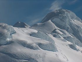
Mount Friesland is a mountain rising to 1,700.2 metres (5,578 ft) in the homonymous Friesland Ridge, the summit of Tangra Mountains and Livingston Island in the South Shetland Islands, Antarctica. Its north rib is connected to Pliska Ridge by Nesebar Gap on the west, and to Bowles Ridge by Wörner Gap on the north. On the east Mount Friesland is connected to Presian Ridge and further on to Catalunyan Saddle and Lyaskovets Peak. On the south-southwest it is connected by a short saddle to 'The Synagogue,' a sharp-peaked rock-cored ice formation abutting neighbouring St. Boris Peak. The peak is heavily glaciated and crevassed, surmounting Huntress Glacier to the west, Perunika Glacier to the north-northwest, Huron Glacier to the northeast and Macy Glacier to the southeast. The local weather is notoriously unpleasant and challenging; according to the seasoned Antarctic mountaineer Damien Gildea who climbed in the area, 'just about the worst weather in the world'.
Contents
Map of Mount Friesland, Antarctica
History
The feature was known to American and British sealers as early as 1820–21, and variously referred to as "Peak of Frezeland", "Friezland Peak", and "Friesland Peak". In the early 1900s the name "Barnard", applied by James Weddell in 1825 to nearby Needle Peak, was transferred to this mountain. The original name has now been restored with the spelling "Friesland" that appears to have been more frequently used than any of the other versions. In order to preserve the historical memory of the area, the name Barnard Point has since been approved for the nearby point on the southeast side of the entrance to False Bay.
The summit elevation was estimated at 1,684 metres (5,525 ft) by a 1995-96 Bulgarian survey; the present figure was produced by a 2003 Australian GPS survey, and confirmed by the Bulgarian survey Tangra 2004/05. The local ice relief is subject to changes, causing variations in the feature’s elevation. According to a Bulgarian GPS survey by D. Boyanov and N. Petkov the elevation of Mt. Friesland was 1,693 m in December 2016, making the peak lower than the adjacent St. Boris Peak (the latter’s northernmost ice formation ‘The Synagogue’ rising to 1,699 m) at that time.
The first ascent of Mount Friesland was made from Juan Carlos I Base on 30 December 1991 by the Catalan climbers Francesc Sàbat and Jorge Enrique, after whom Sàbat Hill and Enrique Hill, respectively, were named. The peak was climbed and GPS surveyed by the Australian Damien Gildea and John Bath and the Chilean Rodrigo Fica on 20 December 2003, who produced a new map of the island in 2004, based on Spanish satellite imagery and their GPS data. The third ascent was made by the Bulgarians Lyubomir Ivanov and Doychin Vasilev from Camp Academia on 15 December 2004. All these used the Sàbat–Enrique eastern route to the peak, from Camp Academia locality (541 m) via Catalunyan Saddle (1,260 m) and Presian Ridge (1,456 m).
Location
Mount Friesland is situated 12.5 kilometres (7.8 mi) northeast of Barnard Point, 9.7 kilometres (6.0 mi) east-southeast of St. Kliment Ohridski Base, 3.6 kilometres (2.2 mi) southeast of the summit of Pliska Ridge, 6.1 kilometres (3.8 mi) south by east of Mount Bowles, 2.9 kilometres (1.8 mi) south-southwest of Camp Academia, 6.7 kilometres (4.2 mi) west of Great Needle Peak, and 6.85 kilometres (4.26 mi) north by west of Samuel Point. British mapping in 1968, Chilean in 1971, Argentine in 1980, Spanish in 1991, US in 2004, and Bulgarian in 1996, 2005 and 2009. Bulgarian surveys 1995/96 (estimated elevation 1684 m) and 2004-05.