
Length 3,745 km | ||
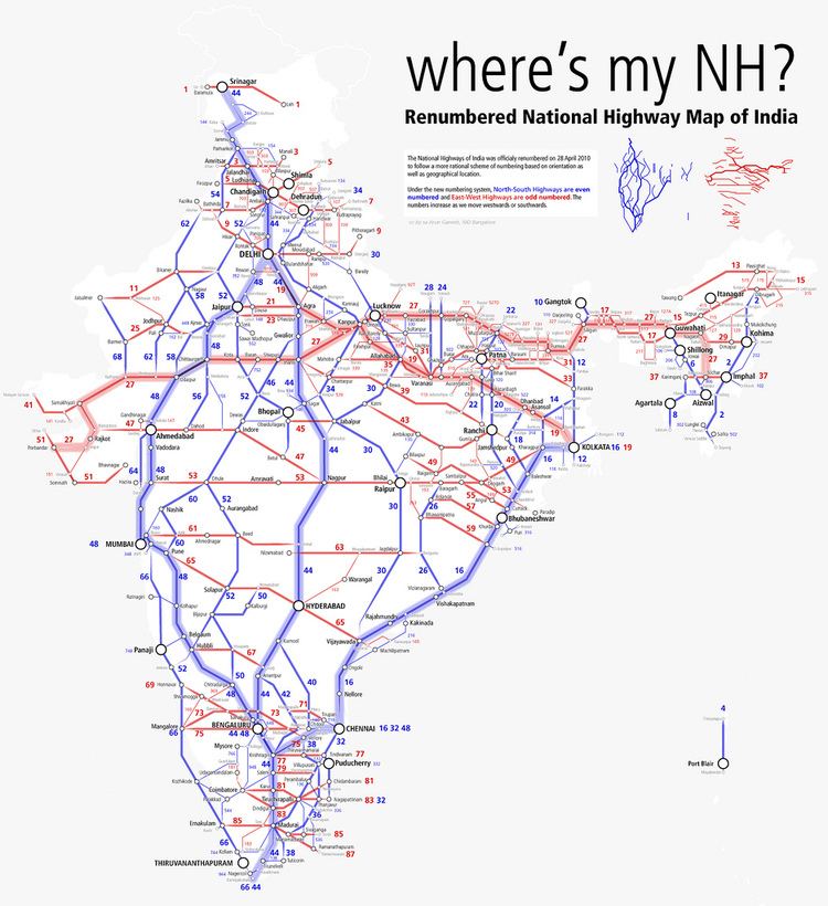 | ||
States: Uttar Pradesh: 128 km (80 mi)Madhya Pradesh: 504 km (313 mi)Maharashtra: 232 km (144 mi)Telangana: 504 km (313 mi)Andhra Pradesh: 250 km (160 mi)Karnataka: 125 km (78 mi)Tamil Nadu: 627 km (390 mi) Primarydestinations: Srinagar - Jammu - Kathua (Jammu & Kashmir)- Pathankot - Jalandhar - Ludhiana (Punjab)- Ambala - Karnal - Panipat (Haryana)- Delhi (Delhi)- Faridabad - Palwal - Mathura - Agra - Dholpur (UP)- Gwalior (MP)- Jhansi - Lalitpur (UP)- Sagar - Narsinghpur - Lakhnadon - Seoni (MP)- Nagpur (Maharashtra)- Adilabad - Nizamabad- Kamareddy - Hyderabad (Telangana)- Kurnool - Anantapur (AP)- Chikkaballapur - Bangalore (Karnataka)- Hosur - Krishnagiri - HuDharmapuri - Salem - Karur - Dindigul - Madurai - Tirunelveli - Kanyakumari (Tamil Nadu) Highway system Indian National Highway System | ||
National Highway 44 (NH 44) is the longest-running major north–south National Highway in India. It starts from Srinagar and terminates in Kanyakumari; the highway passes through the states of Jammu & Kashmir, Punjab, Haryana, Delhi, Uttar Pradesh, Madhya Pradesh, Maharashtra, Telangana, Andhra Pradesh, Karnataka, and Tamil Nadu. NH-44 was laid and is maintained by Central Public Works Department (CPWD).
Contents
Map of NH44
It has come into being by merging seven previously differently numbered national highways in full or part starting from former NH 1A from Srinagar in Jammu & Kashmir, former NH 1 in Punjab and Haryana ending at Delhi, part of former NH 2 starting from Delhi and ending at Agra, former NH 3 (popularly known as Agra-Bombay highway) from Agra to Gwalior, former NH 75 and former NH 26 to Jhansi, and finally former NH 7 via Nagpur, and Adilabad, Nizamabad, Hyderabad and Kurnool in Telengana / Andhra Pradesh, and Bangalore, Dharmapuri, Salem, Tirunelveli and Madurai terminating at Kanyakumari.
Route
This highway starts from Srinagar. The highway connects several important Indian cities such as Srinagar, Jammu, Pathankot, Jalandhar, Ludhiana, Ambala, Karnal, Delhi, Agra, Gwalior, Jhansi, Nagpur, Hyderabad, Bangalore, Dharmapuri, Salem, Karur, Madurai, Tirunelveli and Kanyakumari. NH 44 covers the North-South Corridor of NHDP and it is officially listed as running over 3,745 km (2,327 mi) from Srinagar to Kanyakumari. It is the longest national highway in India.
Route length in states
Bengaluru–Hosur Road
Bangaluru–Hosur Road of this highway which connects the city of Bengaluru capital of Karnataka, and the Tamil Nadu border town of Hosur in Krisnagiri district. It is a four- to six-lane highway which also has service lanes on either sides at the busier parts. Apart from being a part of the National Highway, the road is also significant because it consist of many industrial and IT business houses. The famous IT industrial park Electronics City is also located alongside Hosur Road.
The National Highways Authority of India has constructed a 10-kilometre-long (6.2 mi) elevated highway between Bommanahalli and Electronics City. This toll road has made travel to Electronics City a lot faster. The Bruhat Bengaluru Mahanagara Palike and Bangaluru Development Authority have planned a series of flyovers and underpasses to make this arterial road signal-free.