
Age of rock Carboniferous Area 2.457 million km² | Elevation 2,228 m | |
 | ||
Mountains Mount Kosciuszko, Mount Bogong, Carruthers Peak, Mount Hotham, Mount Townsend Similar Mount Kosciuszko, Australian Alps, Snowy Mountains, Murray River, Lake Eyre | ||
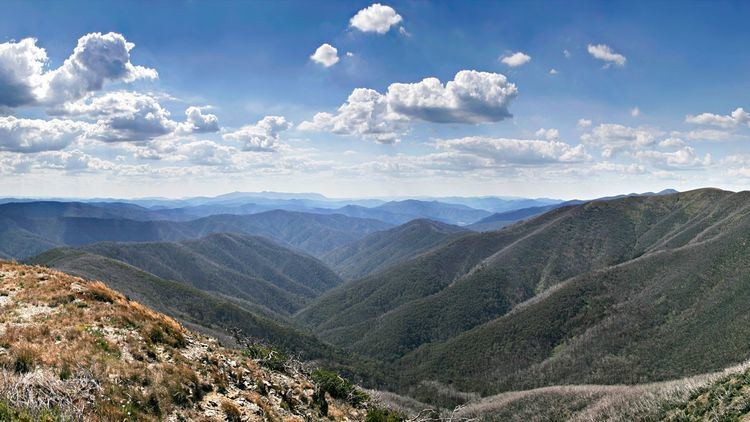
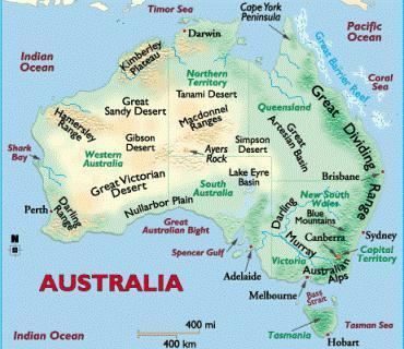
The Great Dividing Range, or the Eastern Highlands, is Australia's most substantial mountain range and the third longest land-based range in the world. The range stretches more than 3,500 kilometres (2,175 mi) from Dauan Island off the northeastern tip of Queensland, running the entire length of the eastern coastline through New South Wales, then into Victoria and turning west, before finally fading into the central plain at the Grampians in western Victoria. The width of the range varies from about 160 km (100 mi) to over 300 km (190 mi).
Contents
- Terminology
- History
- Natural components
- Water catchments
- Features
- Railways
- Road transport
- Protected areas
- References
The sharp rise between the coastal lowlands and the eastern uplands has affected Australia's climate, mainly due to orographic precipitation, and these areas of highest relief have revealed an impressive gorge country.
Terminology
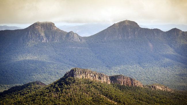
The Dividing Range does not consist of a single mountain range. It consists of a complex of mountain ranges, plateaus, upland areas and escarpments with an ancient and complex geological history. The physiographic division name for the landmass is called the East Australian Cordillera. In some places the terrain is relatively flat, consisting of very low hills. Typically the highlands range from 300 m to 1,600 m in height.
The mountains and plateaus, which consist of limestones, sandstone, quartzite, schists and dolomite, have been created by faulting and folding processes.
The crest of the range is defined by the watershed or boundary between the drainage basins of rivers which drain directly eastward into the Pacific Ocean, or southward into Bass Strait, and those rivers which drain into the Murray–Darling river system towards the west and south. In the north, the rivers on the west side of the range drain towards the Gulf of Carpentaria.
The higher and more rugged parts of the "range" do not necessarily form part of the crest of the range, but may be branches and offshoots from it. The term "Great Dividing Range" may refer specifically to the watershed crest of the range, or to the entire upland complex including all of the hills and mountains between the east coast of Australia and the central plains and lowlands. At some places it can be up to 400 km wide. Notable ranges and other features which form part of the range complex have their own distinctive names.
History
The Great Dividing Range was formed during the Carboniferous period—over 300 million years ago—when Australia collided with what is now parts of South America and New Zealand. The range has experienced significant erosion since. (See Geology of Australia.)
For tens of thousands of years prior to British colonisation the ranges were home to various Aboriginal Australian nations and clans. Evidence remains in some places of their traditional way of life including decorated caves, campsites and trails used to travel between the coastal and inland regions. Many descendants of these nations still exist today and remain the traditional owners and custodians of their lands.
After British colonisation in 1788, the ranges were an obstacle to exploration and settlement by the British settlers. Although not high, parts of the highlands were very rugged. Crossing the Blue Mountains was particularly challenging due to the mistaken idea that the creeks should be followed rather than the ridges, and almost impenetrable, labyrinthine, sandstone mountains.
Knowing that local Aboriginal people already had established routes crossing the range and by making use of Aboriginal walking trails, a usable ridge-top route was finally discovered by Europeans directly westward from Sydney across the Blue Mountains to Bathurst by an expedition jointly led by Gregory Blaxland, William Lawson and William Charles Wentworth. Towns in the Blue Mountains were later named after each of these men. This was the start of the development of the agricultural districts of inland New South Wales. A road was built to Blaxland by convicts within six months. Easier routes to inland New South Wales were discovered towards Goulburn to the southwest, and westwards from Newcastle.
Subsequent explorations were made across and around the ranges by Allan Cunningham, John Oxley, Hamilton Hume, Paul Edmund Strzelecki, Ludwig Leichhardt and Thomas Mitchell. These explorers were mainly concerned with finding and appropriating good agricultural land.
By the late 1830s the most fertile rangelands adjacent to the mountains ranges had been explored, appropriated from the traditional inhabitants and some settled. These included the Gippsland and Riverina regions in the south, up to the Liverpool Plains and the Darling Downs in the north.
Various road and railway routes were subsequently established through many parts of the ranges, although many areas remain remote to this day. For example, in eastern Victoria there is only one major road crossing the highlands from north to south, the Great Alpine Road.
Natural components
Parts of the highlands consisting of relatively flat and, by Australian standards, well-watered land were developed for agricultural and pastoral uses. Such areas include the Atherton Tableland and Darling Downs in Queensland, and the Northern Tablelands, Southern Highlands and Southern Tablelands in New South Wales. Other parts of the highlands are too rugged for agriculture and have been used for forestry. Many parts of the highlands which were not developed are now included in National Parks.
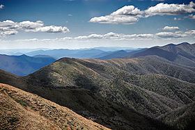
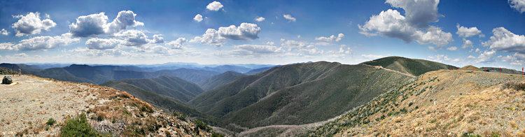
All of mainland Australia's alpine areas, including its highest mountain, Mount Kosciuszko (2,228 metres (7,310 ft) AHD), are part of this range, called the Main Range. The highest areas in southern New South Wales and eastern Victoria are known as the Australian Alps.
The central core of the Great Dividing Range is dotted with hundreds of peaks and is surrounded by many smaller mountain ranges or spurs, canyons, valleys and plains of regional significance. Some of the major plains include the High Plains of South-Eastern Australia, the Southern Highlands the Central Highlands and Bogong High Plains of Victoria. Other tablelands considered part of the Great dividing range are the Atherton Tableland, Canberra wine region and the Southern Tablelands.
The Dandenong Ranges, Barrington Tops, Bunya Mountains, Blue Mountains, Liverpool Range, McPherson Ranges and the Moonbi Range are some of the smaller spurs and ranges that make up the greater dividing range. Other notable ranges and tablelands which form part of the Great Dividing Range include the Liverpool Range, Mount Royal Range and the Monaro District. Whilst some of the peaks of the highlands reach respectable heights of a little over 2,000 metres, the age of the range and its erosion mean that most of the mountains are not very steep, and virtually all peaks can be reached without mountaineering equipment.
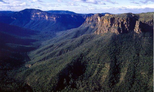
In some areas, such as the Snowy Mountains, Victorian Alps, the Scenic Rim and the eastern escarpments of the New England region, the highlands form a significant barrier. The eastern escarpment is the site of many spectacular waterfalls which were formed by rivers plunging off the tablelands. In other areas the slopes are gentle and in places the range is barely perceptible.
Well known passes on the range include Coxs Gap, Cunninghams Gap, Dead Horse Gap, Nowlands Gap, and Spicers Gap.
Major cities located on the upland areas of the range include Canberra, Toowoomba and the outer suburbs of Sydney, Melbourne, Brisbane and Cairns in north Queensland. Many towns and cities are located on the range, and also in lowland areas and foothills adjacent to the highlands. There is a strong natural history and cultural attachment to the Dividing Range region in towns and on many, sometimes remote landholdings. Some of the towns/cities located on the range include:
Water catchments
The lower reaches are used for forestry, an activity that causes friction with conservationists. The range is also the source of virtually all of eastern Australia's water supply, both through runoff caught in dams, and throughout much of Queensland, through the Great Artesian Basin.
Valleys along the chain of mountains have yielded a water source for important reservoirs and water supply projects such as the Upper Nepean Scheme, Snowy Mountains Scheme and Warragamba Dam. The Bradfield Scheme has been mooted as a way to transport water from the tropics in coastal Queensland south to dryer regions.
The Great Dividing Range creates the drainage basins of the Australian south-east coast drainage division and the Australian north-east coast drainage division, whose water flows to the east coast and into the Pacific Ocean, Tasman Sea, and Bass Strait with the westerly Murray–Darling basin which flow inland, away from the coast into the interior plains.
Some of the rivers which flow west of the ranges includes the Condamine River, Flinders River, Herbert River, Lachlan River, Macdonald River, Macintyre River and Namoi River. Rivers that flow north into the Murray–Darling Basin from Victoria include the Goulburn, Mitta Mitta, Kiewa, Ovens, King, Loddon and Campaspe rivers. Rivers that flow east into the Pacific Ocean include the Brisbane River, Burdekin River, Clarence River, Hastings River, Hawkesbury River, Hunter River, Macleay River, Mary River, Richmond River and the Shoalhaven River. Those that flow south, primarily through Victoria, include the Snowy, Cann, Tambo, Mitchell, Latrobe, Thomson, Yarra, Werribee, Hopkins and Glenelg rivers.
Features
At some high hill passes the range provides cool sites appropriate for vineyards.
Railways
The engineers of early rail passages across the Great Dividing Range needed to find low sections of the range to cross, as well as suitable, low gradient paths up the mountains on either side. Rail passages include:
Road transport
Many of Australia's highways such as the Alpine Way, Great Alpine Road, Hume Highway, Great Western Highway, Capricorn Highway, Cunningham Highway, New England Highway, Oxley Highway, Warrego Highway, Waterfall Way, Thunderbolts Way, the Calder Highway, the Western Highway, and the Murray Valley Highway traverse parts of the range.
Protected areas
Much of the range lies within a succession of national parks and other reserves, most of the national parks are listed below, there are almost double the amount of state forests;