
- elevation 679 m (2,228 ft) - elevation 98 m (322 ft) Country Australia | Basin area 4,179 km² | |
 | ||
- right Cities Kyneton, El, Redesdale, Victoria | ||
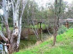
Flooding campaspe river in victoria australia
The Campaspe River, an inland intermittent river of the north–central catchment, part of the Murray-Darling basin, is located in the lower Riverina bioregion and Central Highlands and Wimmera regions of the Australian state of Victoria. The headwaters of the Campaspe River rise on the northern slopes of the Great Dividing Range and descend to flow north into the Murray River, Australia's longest river, near Echuca.
Contents
- Flooding campaspe river in victoria australia
- Map of Campaspe River Victoria Australia
- Campaspe river walk kyneton botanical gardens victoria aerial video
- Location and featuresEdit
- HistoryEdit
- EtymologyEdit
- References
Map of Campaspe River, Victoria, Australia
Campaspe river walk kyneton botanical gardens victoria aerial video
Location and featuresEdit
From its source in the foothills of the Great Dividing Range below Red Hill, the Campaspe River rises in the Wombat State Forest northwest of Bullengarook and southwest of Macedon near Ashbourne and Firth Park, a local camping ground and historical area. The river then flows west of the township of Woodend and continues north through the town of Kyneton. The middle reaches of the river are dominated by Lake Eppalock, a constructed reservoir. The Coliban River, the most significant tributary of the Campaspe, also flows into Lake Eppalock. Towns located on the river in this area include Redesdale located just north of Eppalock and Axedale, located just below Eppalock. The towns of Elmore and Rochester lie on the river's lower reaches. The river meets its confluence with the Murray River west of the town of Echuca, located adjacent to the state border between Victoria and New South Wales.
In addition to the Coliban River, the Campaspe River is joined by six minor tributaries and passes through the Campaspe Weir. The river descends 581 metres (1,906 ft) over its 232-kilometre (144 mi) course.
The river is crossed three times by the Calder Freeway near Kyneton; and by the McIvor Highway near Eppalock. The Midland Highway and the Northern Highway cross the river at Elmore.
HistoryEdit
Indigenous Australians lived in the catchment for millennia.
Europeans arrived in the upper catchment area in 1834. After European settlement, native vegetation was removed from part of the area, which was replanted with willow trees and hedgerows of hawthorn bushes, some of the latter remaining today. Over a number of years the willow growth has been progressively cleared and eradicated by local groups of volunteers. The willow-free parts of the river have been subsequently replanted with indigenous species. Walking routes and cycle tracks have been installed along one bank of the river, creating a sustainable leisure resource for the town.
EtymologyEdit
As the river is relatively long, indigenous peoples from various cultural groups lived near the river course. In the indigenous Yorta Yorta language, the name for the river is Yalka or Yalooka, meaning "dry leaf." In the Daungwurrung language the name for the river is Boregam, with no clearly defined meaning. While in the Daungwurrung and Ngurai-illamwurrung language, the river is named Yerrin, with no clearly defined meaning.
It was named by Major Mitchell in 1836 for Campaspe, a mistress of Alexander the Great.