
Elevation 2,228 m Prominence 2,228 m | Easiest route Walk (dirt road) First ascent 1840 First ascender Paweł Strzelecki | |
 | ||
Isolation 1,894.26 km (1,177.04 mi) Similar Snowy Mountains, Vinson Massif, Aconcagua, Mount Townsend, Puncak Jaya | ||
Climbing mount kosciuszko
Mount Kosciuszko is a mountain located on the Main Range of the Snowy Mountains in Kosciuszko National Park, part of the Australian Alps National Parks and Reserves, in New South Wales, Australia and is located west of Crackenback and close to Jindabyne.
Contents
- Climbing mount kosciuszko
- Map of Mt Kosciuszko Kosciuszko National Park NSW 2627 Australia
- Etymology
- Formation of Mount Kosciuszko
- Reaching the summit
- Recreation
- Higher Australian mountains
- In popular culture
- References
Map of Mt Kosciuszko, Kosciuszko National Park NSW 2627, Australia
With a height of 2,228 metres (7,310 ft) above sea level, it is the highest mountain in mainland Australia. Various measurements of the peak originally called Kosciuszko showed it to be slightly lower than its neighbour, Mount Townsend. The names of the mountains were swapped by the New South Wales Lands Department in 1892 so that Mount Kosciuszko remains the name of the highest peak of Australia, and Mount Townsend ranks as second. The 1863 picture by Eugene von Guerard hanging in the National Gallery of Australia titled "Northeast view from the northern top of Mount Kosciusko" is actually from Mount Townsend.
Etymology
It was named by the Polish explorer Pawel Edmund Strzelecki in 1840, in honour of the Polish national hero, General Tadeusz Kościuszko, because of its perceived resemblance to the Kościuszko Mound in Kraków.
The name of the mountain was previously spelt "Mount Kosciusko", an Anglicisation, but the spelling "Mount Kosciuszko" was officially adopted in 1997 by the Geographical Names Board of New South Wales. The traditional English pronunciation of Kosciuszko is /kɒziːˈʌskoʊ/, but the pronunciation /kɒˈʃʊʃkoʊ/ is now sometimes used, which is substantially closer to the Polish pronunciation [kɔɕˈt͡ɕuʂkɔ].
There are several native Aboriginal (Ngarigo) names associated with the mountain, with some confusion as to the exact sounds. These are Jagungal, Jar-gan-gil, Tar-gan-gil, Tackingal; however, all of them mean "Table Top Mountain."
Formation of Mount Kosciuszko
The mountain was formed, by geologic uplift,.
Reaching the summit
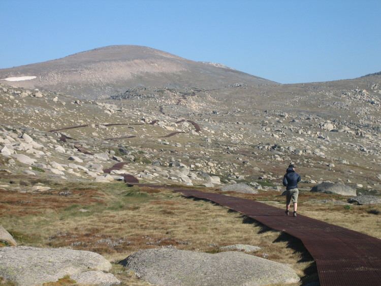
Mount Kosciuszko is the highest summit in mainland Australia. Until 1977 it was possible to drive from Charlotte Pass to within a few metres of the summit, but in 1977 the road was closed to public motor vehicle access due to environmental concerns. The road is open from Charlotte Pass for walkers and cyclists for 7.6-kilometre (5 mi) to Rawson Pass, at an elevation of 2,100 metres (6,900 ft) above sea level. From there a 1.4-kilometre (1 mi) walking path leads to the summit. Cyclists must leave their bicycles at a bicycle rack at Rawson Pass and continue to the summit on foot. Anyone with a modest level of fitness can walk to the top.
The peak may also be approached from Thredbo, taking 3 to 3.5 hours for a round trip. This straightforward walk starts from the top of the Thredbo Kosciuszko Express chairlift, which operates all-year round. The walking path is popular in summer, and is a mesh walkway to protect the native vegetation and prevent erosion. It is 5 kilometres (3.1 mi)} to Rawson Pass, where it meets the track from Charlotte Pass, and from where it is a further 1.4 kilometres (0.87 mi) to the summit.
Australia's highest public toilet was built at this pass in 2007, to cope with the more than 100,000 people visiting the mountain each summer.
The peak and the surrounding areas are snow-covered in winter and spring (usually beginning in June and continuing until October or later). The road from Charlotte Pass is marked by snow poles and provides a guide for cross-country skiers and the track from Thredbo is easily followed until covered by snow in winter.
Recreation
Kosciuszko National Park is also the location of the downhill ski slopes closest to Canberra and Sydney, containing the Thredbo, Charlotte Pass, and Perisher ski resorts. Mount Kosciuszko may have been ascended by Indigenous Australians long before the first recorded ascent by Europeans.
Each year in December, an ultramarathon running race called the Coast to Kosciuszko ascends to the top of Mount Kosciuszko after starting at the coast 240 kilometres (150 mi) away. Paul Every, who is credited as being the one who thought of holding such a race, was the inaugural co-winner in 2004.
Higher Australian mountains
Higher peaks exist within territory administered or claimed by Australia, but outside the continent:
Higher peaks in the region, but outside the mainland continent:
In popular culture
Australian rock band Midnight Oil performed a song called "Kosciusko" on its 1984 album Red Sails in the Sunset, referring to the mountain. The spelling was updated to "Kosciuszko" for the group's 1997 compilation album, 20,000 Watt R.S.L.