
Mouth Tasman Sea Mouth elevation 0 | ||
 | ||
- left Jacksons Creek (Moyne Shire, Victoria), Salt Creek (Moyne Shire, Victoria), Stony Creek (Moyne Shire, Victoria), Mount Emu Creek, Brucknell Creek - right Back Creek (Moyne Shire, Victoria), Reedy Creek (Moyne Shire, Victoria), Bushy Creek (Moyne Shire, Victoria), Back Creek, Two (Moyne Shire, Victoria), Chirrup Creek, Grays Creek, Mustons Creek Similar Lake Burrumbeet, Cumberland River, Mitchell River, Hopkins Falls, Steavenson River | ||
Ellerslie on hopkins river south west victoria australia
The Hopkins River, a perennial river of the Glenelg Hopkins catchment, is located in the Western District of Victoria, Australia.
Contents
- Ellerslie on hopkins river south west victoria australia
- Map of Hopkins River Victoria Australia
- 90daysdownunder road trip big4 hopkins river grilled caesar salad pizza
- Course and features
- River Health
- Re vegetation
- Phase 1
- Phase 2 3
- Etymology
- References
Map of Hopkins River, Victoria, Australia
90daysdownunder road trip big4 hopkins river grilled caesar salad pizza
Course and features
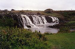
The Hopkins River rises below Telegraph Hill near Ararat, and flows generally south, joined by twelve tributaries including the Mount Emu Creek, before reaching its mouth and emptying into Bass Strait at Warrnambool. The river descends 338 metres (1,109 ft) over its 271-kilometre (168 mi) course. The river and its tributaries drain much of Lake Bolac; and north of Allansford the river descends over the 11–13-metre (36–43 ft) Hopkins Falls.
Together with the Merri River, the Hopkins flows through the regional centre of Warrnambool; and the river is traversed by the Great Ocean Road.
River Health
The Hopkins River is in extremely poor health with less than 5% of the river having natural bush and vegetation.
Re-vegetation
The Hopkins River Re-vegetation Project (HRRP) was commenced in 2016 by the Ellerslie Residents Group Inc.
Phase 1
Phase 1 of the HRRP project commenced in 2016 in Ellerslie. The Project is located between the Hopkins Highway bridge and the historic bridge.
Phase 2 & 3
Phases 2 & 3 of the project are planned to take place on the eastern bank between the phase 1 site and the Ellerslie cemetery. As at 3/1/2017 Phase 2 and 3 cannot take place due to grazing licences on the crown land allotments. The Department of Environment, land, Water & planning have refused to support the project for more than 15 years. They have continued to renew the grazing licences despite the Ellerslie community demanding that the licences be concealed.
Etymology
The river was named in 1836 by Major Thomas Mitchell after a friend, Sir John Paul Hopkins.