
Length 344 km Source Mount Stanley Islands Bishop Island | ||
 | ||
Similar South Bank Parklands, Mount Coot‑tha - Queensland, Wheel of Brisbane, Story Bridge, Roma Street Parkland | ||
Brisbane river cruise natural australia beautiful brisbane
The Brisbane River is the longest river in South East Queensland, Australia, and flows through the city of Brisbane, before emptying into Moreton Bay. John Oxley was the first European to explore the river who named it after the Governor of New South Wales, Thomas Brisbane in 1823. The penal colony of Moreton Bay later adopted the same name, eventually becoming the present city of Brisbane.
Contents
- Brisbane river cruise natural australia beautiful brisbane
- Map of Brisbane River Queensland Australia
- Course
- Kangaroo Point Cliffs
- Reaches
- Tributaries
- History
- 20th century
- Floods
- Navigation
- Crossings
- Brisbane Riverwalk
- Cross river tunnel
- Environmental concerns
- Flora
- Fauna
- Brisbane River cod
- Bull sharks
- Events
- References
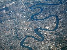
Map of Brisbane River, Queensland, Australia
Early travellers along the waterway admired the natural beauty, abundant fish and rich vegetation along its banks. From 1862 the Brisbane River has been dredged for navigation purposes. The river served as an important carriageway between Brisbane and Ipswich before a railway linking the towns was built in 1875. By the late 1920s, water quality in the river had significantly deteriorated. The river contains excess nutrients, hydrocarbons, pesticides, bacteria and is murky.
The river travels 344 km (214 mi) from Mount Stanley. The river is dammed by the Wivenhoe Dam, forming Lake Wivenhoe, the main water supply for Brisbane. The waterway is a habitat for the rare Queensland lungfish, Brisbane River cod and bull sharks. The largest ship built on the river was the Robert Miller. The 66,000 tonne vessel became un-moored in the 1974 Brisbane flood. While not the highest experienced along the river since European settlement, this flood was the most damaging. Major floods also occurred in January 2011 and multiple times during 1893.
Extensive port facilities have been constructed on the Fisherman Islands, now known as the Port of Brisbane. There are 16 major bridges that cross the river. The Clem Jones Tunnel, opened in 2010, is the river's first underground crossing for road transport. The CityCat ferry service collects and delivers passengers along the inner-city reaches of the river.
Course
Brisbane River's source is located in the Great Dividing Range, east of Kingaroy. It then makes its way south, past Mount Stanley, and townships including Moore and Toogoolawah before being joined by the Stanley River, just south of Somerset Dam.
The river runs from there into Lake Wivenhoe, created by the Wivenhoe Dam. Beyond the dam, the river meanders eastward, meeting the Bremer River near Ipswich, then making its way through Brisbane's western suburbs, including Jindalee, Indooroopilly and Toowong. The river is travelled upon by CityCats and other ferries in Brisbane, winding its way through the city centre.
Water from the highest point in the catchment has fallen from Mount Langley in the Conondale Range, 868 m above sea level. The Brisbane River then flows past wharves including Pinkenba Wharf and Portside Wharf, past Bulwer Island and Luggage Point through the Port of Brisbane and into southern Bramble Bay an embayment of Moreton Bay.
Kangaroo Point Cliffs
On the southern side of the river, opposite Gardens Point, are the Kangaroo Point Cliffs; made from Triassic aged volcanic rock of rhyolite composition called Brisbane tuff. The Kangaroo Point Cliffs were created by a quarrying operation that, according to Allan Cunninghams' Field Book, was underway prior to 1829 when he observed a "stone wharf presumably used for landing the blocks of stone ferried across the river for the construction of buildings in the settlement". This was in the vicinity of Edward Street ferry terminal. The volcanic rock Ignimbrite which formed the cliffs was deposited in the Triassic period about 220 million years ago. They currently form the banks of the Brisbane River.
Reaches
A number of the reaches of the Brisbane River are named, including the following listed below (from upstream to downstream), together with their location relative to tributaries of the river and river crossings:
Tributaries
The following major tributaries flow into the Brisbane River from the north; Breakfast Creek, Moggill Creek and the Stanley River. On the southside Bulimba Creek, Norman Creek, Oxley Creek, Bremer River and Lockyer Creek waterways enter the Brisbane River. The following smaller creeks also flow into the river; Cressbrook Creek, Cooyar Creek, Cubberla Creek, Wolston Creek, Woogaroo Creek, Goodna Creek, Six Mile Creek, Bundamba Creek, Pullen Pullen Creek and Kholo Creek.
History
Before European settlement, the Brisbane River was spiritually important and a vital food source for the Aboriginal people of the Turrbal nation, primarily through fishing in the tidal sections downstream, with fishing and firestick farming in the upper reaches where there was freshwater, depending on the season. The language group common to most of the area was the Yugarabul language group.
Four European navigators, namely Captain Cook, Matthew Flinders, John Bingle and William Edwardson, all visited Moreton Bay but failed to discover the river. The exploration by Flinders took place during his expedition from Port Jackson north to Hervey Bay in 1799. He spent a total of 15 days in the area, touching down at Woody Point and several other spots, but failed to discover the mouth of the river although there were suspicions of its existence. This is consistent with accounts of many other rivers along the east coast of Australia, which could not be found by seaward exploration but were discovered by inland travellers.
On 21 March 1823, four ticket-of-leave convicts sailing south from Sydney on a timber getting mission to Illawarra, Thomas Pamphlett, John Finnegan, Richard Parsons and John Thompson were blown north by a storm. They went 21 days without water, continuing north in the belief they had been blown south, during which time Thompson died. They landed on Moreton Island on 16 April and made it to the mainland on the south of the Brisbane River. They immediately began trekking north in order to return to Sydney, still believing themselves to be somewhere south of Jervis Bay. Subsequently, they became the first known Europeans to discover the river, stumbling across it somewhere near the entrance. They walked upstream along its banks for nearly a month before making their first crossing at 'Canoe Reach', the junction of Oxley Creek. It was here they stole a small canoe left by the Australian Aborigines of the region.
John Oxley was Surveyor General of New South Wales when, in the same year and under orders from Governor Brisbane, he sailed into Moreton Bay looking for a suitable new site for a convict settlement to be established. An entry in Oxley's diary on 19 November 1823 describes his surprise meeting with one of the shipwrecked men:
"We rounded the Point Skirmish about 5 o'clock and observed a number of natives running along the beach towards the vessel, the foremost much lighter in colour than the rest. We were to the last degree astonished when he came abreast the vessel to hear him hail us in good English."By that time Pamphlett and Finnegan were living with natives near Bribie Island. Parsons, who had continued to travel north in search of Sydney, was picked up by Oxley on 11 September 1824.
On 2 December 1823, Oxley and Stirling, with Finnegan as a somewhat reluctant guide, entered the river and sailed upstream as far as present-day Goodna. Oxley noted the abundant fish and tall pine trees. Early European explorers marvelled at the sheer natural beauty they witnessed while travelling up the lower reaches.
Reports by early European explorers such as Allan Cunningham and Oxley indicate rainforest once fringed the Brisbane River and its major tributaries, especially on the broader floodplains such as St Lucia and Seventeen Mile Rocks. The coastal lowlands were extensively vegetated with Melaleuca woodlands in low lying, poorly drained coastal areas. When first described by Europeans, the lower reaches of the Brisbane River were fringed by a mosaic of open forest, closed forest and rainforest.
In the same year of 1823, the river was named after Sir Thomas Brisbane, the then Governor of New South Wales. Upon the establishment of a local settlement in 1824, other explorers such as Allan Cunningham, Patrick Logan and Major Edmund Lockyer made expeditions and surveys further upstream, and, in May 1825, the Moreton Bay penal colony at Redcliffe under the command of Heny Miller relocated to North Quay.
The entrance to the Brisbane River was surveyed and marked with buoys in May 1825 by Pilot John M Gray sent from Sydney for the purpose by Governor Sir Thomas Brisbane. Pilot John M Gray also transferred the soldiers and convicts from the First Settlement at Redcliffe at this time.
The first small private wharves were built on the river in about 1848. and the once popular, shark-proof river baths were first built in 1857 at Kangaroo Point.
From 1862 the Brisbane River has been dredged for navigation purposes. Throughout much of the 20th century large quantities of sand and gravel were extracted from the estuary of the river. Since the rate of materials being deposited is not as high as that which was removed, the river has acted as a subaqueous mine.
In 1866 there was a breakwater built at the junction of the Bremer and Brisbane rivers that was designed to stop shingle from blocking the access to the Bremer's boat channel. The first pile light using kerosene was built in 1882. The steel framed light also served as an early port signal station.
20th century
By 1928, due to the early settlement of Brisbane, the water quality had deteriorated to the point where several public baths had to cease sourcing water from the river. Yet even up to the 1930s, the water was said to be very clear, with reports of people seeing the river bed 5 to 6 m (16 to 20 ft) below the surface. Swimming was once popular at Oxley Point under the Walter Taylor Bridge. In the middle tidal reaches in more recent times, visibility has been about 0.2 m (8 in). As Brisbane grew, the condition of the river worsened until at its worst it was no more than an open sewer and waste dump. The banks were cleared of timber and introduced animals and plants rapidly changed the river's ecology to its detriment.
On 25 March 1941, a USA goodwill flotilla arrived in the city docking at wharves along the River. The largest ship built on the river was the Robert Miller. Construction was near complete when the 66,000 tonne vessel became un-moored in the 1974 Brisbane flood. In 1977, Queen Elizabeth II switched on the Jubilee Fountain positioned in front of the proposed Queensland Cultural Centre. The jets pushed the floodlit river water up to 75 m (246 ft) in the air. The floating fountain sank late on the 31 December 1984. 1987 was proclaimed the "Year of the River" by the Lord Mayor of Brisbane at the time, Sallyanne Atkinson.
Floods
The Brisbane River floods frequently, although the occurrence and magnitude of flooding has diminished following the construction of the Wivenhoe Dam on the upper reaches of the River.
Past floods have resulted in both deepening and reduction in river depth, creation of new sand banks and shoals as well as increased transport of suspended sediment from upstream. Before the invention of modern dredging techniques the sediment deposited by flooding created hazards to ships navigating the river. Even medium-sized vessels no longer travel up the Brisbane River beyond the city reach, and dredging of the upper reaches has ceased, allowing the river to recover substantially from the fine silt dislodged by gravel and sand extraction.
Significant floods have occurred several times since the European settlement of Brisbane. Seven major flood peaks have been recorded at the Brisbane gauge since records began in 1841, including:
Flooding along the Brisbane River has the potential to be devastating, as documented in 1974 and 2011. For much of the river's length its banks are relatively high, but topped by a broad plain. The river's meandering course means that flood waters from upstream cannot be quickly discharged into Moreton Bay. Thus higher than normal flows cause river levels to rise rapidly and once the top of the banks are breached the floodwaters can spread over wide areas of the city.
Navigation
There has been much dredging and widening work done over the years to allow ships to transport cargo to and from Brisbane. The river served as an important carriageway between Brisbane and Ipswich before a railway linking the towns was built in 1875. By early 1825 buoys were being laid along the South Passage and shortly after that the first pilots were commissioned to guide ships entering from Moreton Bay and another service for those travelling upstream. Flying boats used the waters of the river in Pinkenba, to take-off for domestic and international destinations in the 1930s.
The river depth was progressively increased and narrow points widened to allow larger vessels into the river and further upstream. For navigation and safety reasons the Seventeen Mile Rocks were completely removed in 1965 after numerous partially successful attempts in the past. The northern river bank at the mouth of the river has undergone reclamation projects over the years, especially in the suburbs of Hamilton and Pinkenba. More recently, extensive port facilities have been constructed on Fisherman's Island which has also seen significant land reclamation into the bay.
Early rivers crossings were made using small oared boat ferries, beginning in 1843, followed by steam ferries. In 1865 the first Victoria Bridge, later destroyed in a flood, was built across the river. Professor Hawken of the University of Queensland undertook a study in 1914 to identify the future crossing points for the river.
Historically, the Brisbane River contained upstream bars and shallows and had a natural tidal limit of only 16 km (10 mi). The current tidal limit now extends 85 km (53 mi) upstream due to continual channel dredging.
Crossings
The first bridge built across the Brisbane River was the original timber Victoria Bridge, opened in 1865 between Brisbane and South Brisbane. The current concrete Victoria Bridge is the 4th to be built on the site, the original bridge collapsed after marine borers weakened its timber piles, and the second was destroyed in the 1893 flood.
As of 2012 the Brisbane River is crossed by 16 major bridges (counting the new second Gateway, now Sir Leo Hielscher Bridge), including the historic 1940 Story Bridge and the tolled Sir Leo Hielscher Bridges. There are two other major bridges upstream (west) of Brisbane, on the D'Aguilar Highway and the Brisbane Valley Highway. The Clem Jones Tunnel, opened in 2010, is the river's first underground crossing for road transport.
The Moggill Ferry continues to provide a crossing for vehicles northeast of Ipswich.
The Albert Bridge was the first railway crossing of the Brisbane River, opened in 1876. It was destroyed in the 1893 flood and replaced by a 2 span design that is flood tolerant. A second bridge was built adjacent to it, opened in 1957 in conjunction with the quadruplication of the railway between Roma Street and Corinda. The Merivale Bridge, opened in 1978, connects the South Brisbane railway system to the City.
Four bridges have been built that cater for pedestrians and bicycles, being the Goodwill Bridge and Kurilpa Bridge in the City area, the Eleanor Schonell Bridge between Dutton Park and St Lucia (which also caters for public buses to the University of Queensland St Lucia campus), and the Jack Pesch Bridge between Indooroopilly and Chelmer. The Brisbane City Council has announced plans for a pedestrian and cycle only bridge between Kangaroo Point and the city.
Brisbane Riverwalk
The Brisbane City Council has developed a network of riverwalk pavements along the banks of the Brisbane River. Jim Soorley, a former mayor of Brisbane, encouraged serious investment into the quality and capacity of the Brisbane riverwalk.
An interesting section is the floating walkway between the Story Bridge and Merthyr Street New Farm. Brisbane City planners require many developers of formerly private riverfront blocks to create new sections of the Brisbane Riverwalk that are accessible to the public.
During the 2011 floods, the Lord Mayor of Brisbane, Campbell Newman authorised the destruction of the Brisbane Riverwalk to prevent it floating away and becoming a hazard downstream. The proposed demolition of the Riverwalk was later cancelled.
Early in the morning of 13 January 2011 a several hundred metre long section of the Riverwalk broke away from the main structure and floated downstream. Queensland Police temporarily closed the Sir Leo Hielscher Bridges (commonly known as the Gateway Bridge) several times as there were fears that sections of Riverwalk could collide with and damage the bridge. The largest part of the floating boardwalk was safely guided under the bridge by a tugboat and past other infrastructure before being safely secured. Other tugs and Water Police guided other Riverwalk sections under the bridge. The damaged Riverwalk was rebuilt as a fixed structure by the Brisbane City Council. The 18-month construction commenced in early 2013 and was completed in September 2014.
Cross river tunnel
The Clem Jones Tunnel is currently the only cross river tunnel built in Brisbane. It opened on 16 March 2010.
Environmental concerns
During the 19th century and early 20th century, the river's surface was periodically choked by large swathes of the noxious weed known as water hyacinth. The plant was originally imported from South America.
Environmentally, the river is in a poor condition and has been so for many years. In 2000, the Brisbane River estuary did not meet the national guidelines for environmental standards. The lower reaches received a very poor rating in the 2008 Healthy Waterways report, an annual assessment of river water quality. The major causes of pollution are excess nutrients, hydrocarbons, pesticides and bacteria which become concentrated in the river and its sediment after flowing off surrounding lands. The river is also considered too murky and it is not recommended to swim in its waters.
Historically, the river was actively dredged by Boral Sands Inc, ostensibly to make the river navigable. The constant extraction of river bed material by dredges has had considerable effect on the river. These impacts include increased turbidity, bed and bank erosion and changes in tidal hydraulics. The tidal nature of the river and the generally muddy nature of the sands removed by dredging created a woefully sludgy clayey sediment load in the river which did not clear.
The efficacy of dredging the river upstream of the city reach to make it "navigable" was always in doubt, and the effect of the artificial sediment load in Moreton Bay grew to concern environmentalists worried that sediment was choking sea grass paddocks which were grazing territory for dugong. In a meeting concerning the matter in October 1996, including two State Government Ministers and three Mayors, an agreement to cease the dredging of sand and gravel from the river by 30 September 1997 was formed. Boral Resources Pty. Ltd. resisted the agreement, but ultimately all dredging was stopped by the agreed date.
Flora
The river has several important ecological areas where remnant populations of mangroves exist; these include areas around drainage culverts, in Breakfast Creek, New Farm, a small preserve at the city bend, near the Queensland University of Technology and around the shipping terminals at the river's terminus into Moreton Bay. These mangroves have recently become classified as protected nature reserves. The noxious water hyacinth weed is still growing in stretches between Fernvale and the Mount Crosby Weir but only poses a minimal risk to drinking water supplies.
Fauna
The waterway is a habitat for the rare Queensland lungfish.
Brisbane River cod
The freshwater reaches of the Brisbane River once supported a unique species of cod, the Brisbane River cod, which was similar to Murray cod and closely related to eastern freshwater cod and Mary River cod. Unfortunately this unique native fish became extinct somewhere between the 1930s and 1950s due to habitat degradation and overfishing. The river has been restocked with cod from the Mary River.
Bull sharks
The Brisbane River is home to a very large population of bull sharks, thus swimming is not advised due to the dangers imposed by this predator. Ipswich City Council warns against swimming as far up as Colleges Crossing. There have been four recorded shark attack deaths in the river (1862, 1880, 1901 and 1921), and numerous other fatal attacks in surrounding rivers and estuaries. There have also been numerous attacks on family pets, such as dogs. The shark can be aggressive, grow up to 3 m (10 ft) in length and is unusual for a shark species because it can inhabit water containing less than 50% seawater.
Events
The Brisbane River hosts numerous events including the Riverfestival, Riverfire, and the Brisbane River Classic fishing competition. Many schools and clubs use the river to conduct rowing regattas on Milton Reach. Sailing regattas are also held on this reach as well as the Hamilton reach.
Riverfestival, which began in 1998, was a week-long festival held in September each year at South Bank Parklands and surrounding areas (including the Victoria Bridge), to celebrate the Brisbane River. In 2009, the festival merged with Brisbane Festival. Riverfire, which is held at the end of the Brisbane Festival, includes a fireworks display. The final dump-and-burn of Riverfire 2010 was able to be seen as far as the Gold Coast and Toowoomba as the F-111 climbed from 300 ft (91 m) to a higher altitude of about 10,000 ft (3,000 m).