
Type Highway | Length 338 km | |
 | ||
Route number(s) National Route 42(Goondiwindi-Warwick) National Highway 15(Warwick-Blackstone, Ipswich) National Highway A15(Blackstone-Riverview) Major settlements Yelarbon, Inglewood, Warwick | ||
The Cunningham Highway is a 327-kilometre (203 mi) national highway located in south-eastern Queensland, Australia. The highway links the Darling Downs region with the urbanised outskirts of Ipswich via Cunninghams Gap.
Contents
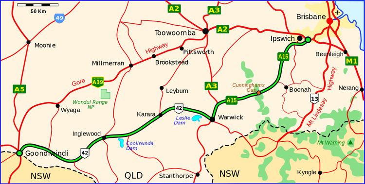
Map of Cunningham Hwy, Queensland, Australia
The Cunningham carries the National Highway 15 shield between Ipswich and north of Warwick at its junction with the New England Highway where both the Cunningham and the New England head south concurrently to Warwick. Thereafter, the Cunningham carries the National Highway 42 shield to its south-western terminus with the Leichhardt Highway at Goondiwindi. The majority of the Cunningham Highway is a single carriageway and freeway standard and 6-lane arterial road standard towards its north-eastern terminus, near Ipswich.
History
The highway is named in honour of the explorer and botanist Allan Cunningham who followed a route close to where the modern day highway runs. In 1828 after discovering the route Cunningham sent a report to Governor Ralph Darling emphasising the economic benefits that a link between the coast and pastoral lands of the Darling Downs would provide. The first road between the coast and the Darling Downs was Spicers Gap Road developed in 1859, which crossed the range at Spicer's Gap and was suitable for the drays used at that time. Although Cunningham's Gap was known at that time, it was considered too steep a route for drays. With the opening of the Southern railway line between Toowoomba and Warwick in 1871, passenger and goods transport switched to the railways and Spicers Gap Road fell into disuse and was not maintained well due to the cost.
It was not until the advent of automobiles that a route through the steep Cunningham's Gap beame feasible. The original road was built entirely by voluntary labour and Acting Queensland Premier, William Forgan Smith, officially opened on 11 June 1927, the 100-year anniversary of Allan Cunningham's supposed discovery of Cunningham's Gap. Actually, Cunningham discovered two gaps, Spicer's Gap on 11 June 1827 as he approached from the Darling Downs side and Cunningham's Gap on 21 August 1828 as he approached from Ipswich. However, Cunningham mistakenly believed he had found both sides of the same gap and not two different ones. This mistake was then perpetuated on the monument to Cunningham unveiled as part of the official opening of the road, as it gave 11 June 1827 as the discovery of Cunningham's Gap.
The road was plagued by problems during this embryonic stage with the Royal Automobile Club of Queensland announcing that the road was closed, less than one month after it was officially opened. In 1935, the Mains Road Commission upgraded the road to highway and named it the Cunningham Highway. The new sealed road through the gap was eventually opened in November 1949.
Route
The north-eastern terminus of the Cunningham Highway is situated a short distance west of where the Warrego Highway reaches its eastern terminus with the Ipswich Motorway, at Riverview, a suburb of Ipswich. From this point, the Cunningham heads south-west as the Cunningham Motorway, bypassing to the south the Ipswich central business district, the original path of the highway, now named Warwick Road. The motorway transitions to the Cunningham Highway, and a further modern deviation takes the highway south of Willowbank and RAAF Base Amberley through the Scenic Rim region including the towns and settlements of Warrill View, the Fassifern Valley and Aratula.
From this point, the Cunningham Highway begins its ascent across the Great Dividing Range via a mountain pass at an elevation of 787 metres (2,582 ft) above sea level called Cunninghams Gap, situated in the Main Range National Park, between the peaks of Mount Cordeaux and Mount Mitchell.
As the Cunningham Highway descends through the Southern Downs region and west adjacent to the settlement of Maryvale, it reaches a major junction with the New England Highway near Eastments Ridge approximately 14 kilometres (8.7 mi) north of Warwick. The two highways run south to Warwick, sharing the National Route 15 shield and cross the Condamine River before the concurrency terminates and the New England Highway runs south, carrying the National Highway 15 shield; and the Cunningham heads west by south-west through Inglewood, Yelarbon, before reaching its south-western terminus on the outskirts of Goondiwindi.
Within close proximity of Goondiwindi, the Cunningham Highway links to the Newell, Leichhardt, and Barwon highways, with the Bruxner Highway nearby.
Towns on the Cunningham Highway
From northeast to southwest, the following towns and settlements are located on the Cunningham Highway: