
Type Highway | Length 721 km | |
 | ||
Route number(s) State Highway M2
(Ipswich Motorway - Pine Mountain Road, Brassall)
National Highway A2
(Pine Mountain Road, Brassall - Landsborough Highway)
Alternate National Highway A2
(Landsborough Highway - Mitchell Highway) SE end Ipswich Motorway /
Cunningham Highway, Ipswich, Queensland NW end Mitchell Highway, Charleville, Queensland Major cities Toowoomba, Dalby, Roma, Mitchell, Miles, Morven Via Toowoomba, Dalby, Miles, Roma, Mitchell, Morven Major settlements Toowoomba, Dalby, Miles, Roma, Mitchell Highway, Morven | ||
The warrego highway
The Warrego Highway is located in southern Queensland, Australia. It connects coastal centres to the south western areas of the state, and is approximately 750 km in length. It takes its name from the Warrego River, which is the endpoint of the highway. The entire highway is part of the National Highway system linking Darwin and Brisbane: formerly National Highway 54, Queensland began to convert to the alphanumeric system much of Australia had adopted in the early-2000s and is now designated as National Highway A2.
Contents
- The warrego highway
- Map of Warrego Hwy Queensland Australia
- Route description
- Terrain
- Speed zones
- Towns along the route
- History
- Toowoomba Second Range Crossing
- Dalby Eastern Western Access Upgrades
- Darren Lockyer Way
- The Toll Bar
- References
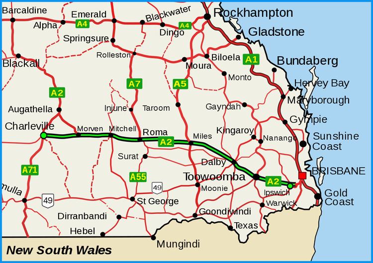
Map of Warrego Hwy, Queensland, Australia
Route description
The highway commences at the end of the M2 Ipswich Motorway, near Ipswich, and climbs the Great Dividing Range to Toowoomba. After reaching the top of the Toowoomba Range, the highway passes through the city via Cohoe, James, Tor and Bridge streets (although many smaller vehicles prefer to turnoff at the top of the range and use Margaret Street). The Warrego then crosses the Darling Downs, bypassing the town of Oakey and then passing through the towns of Dalby, Chinchilla and Miles, in the Western Downs. The highway continues through the towns of Roma and Mitchell in the Maranoa Region of South West Queensland. After Morven, the highway's thoroughfare continues down the Landsborough Highway, with the western turnoff continuing the Warrego Highway down to its terminus at Charleville.
The first section of highway between Ipswich and Toowoomba is mostly motorway grade; a four lane divided highway with motorway-style on-ramps and off-ramps. After the final set of traffic lights in Toowoomba, the highway merges from 4 to 2 lanes (however, throughout 2017-2019, the highway will be duplicated up until Oakey) Then, the highway mostly continues in a straight line with minimal turns. At Dalby, the highway briefly returns to 4 lanes (with a longer stretch of the highway to be duplicated in 2017). The Warrego then continues as a rural 2 lane highway, until Charleville.
Terrain
The Warrego Highway's lowest point along its length is 3.69 m just east of where it crosses the Bremer River near Ipswich, and its highest elevation is 665 m at the top of the Great Dividing Range in Toowoomba.
Speed zones
Towns along the route
From east to west, the highway passes through or close to the cities and major towns of:
History
In January 2011, the highway was extensively damaged where it crosses the Toowoomba Range. This included land slips, shoulder and embankment erosion, the erosion of drains and damaged rock fall netting. The road wasn't fully repaired with all four lanes open until September 2011.
Toowoomba Second Range Crossing
The Toowoomba Second Range Crossing is a major road proposal aimed at bypassing the urban area of Toowoomba and providing a better crossing of the Great Dividing Range. The bypass will link the Warrego Highway at Helidon (in the east) with the highway at Charlton (in the west). The bypass will continue to the Gore Highway and will be 41 km in length. It is expected to be completed in late 2018.
Dalby Eastern & Western Access Upgrades
These upgrades will begin in 2017 and will fully duplicate the highway to 4 lanes, between Cecil Plains Road and Black Street. 4 new traffic signals will be added at Black Street, Jandowae Road, Orpen Street and a pedestrian signal near Owen Street.
Darren Lockyer Way
On 28 September 2011 the Queensland Main Roads Minister, Craig Wallace, announced that an 85 km stretch of the Warrego Highway was to be renamed Darren Lockyer Way, in honour of the retired Brisbane Broncos, Queensland and Australian rugby league captain. The section of road renamed is from Riverview to the bottom of the Toowoomba Range at Withcott. Special signage including "Welcome to Darren Lockyer Way" has been erected.
The "Toll Bar"
The section of the Warrego Highway from Withcott to the top of the Toowoomba Range was first opened in January, 1855 as a toll road, named Toll Bar Road. The toll collection point was marked by a bar across the road and a fence on either side. The upper section of Toll Bar Road was initially unsealed and very steep, with grades up to 14%. This road remained in use until December, 1939, when work on a new, less steep, upper section was completed. Part of the upper section is now a suburban street named Old Toll Bar Road. The term "The Toll Bar" is sometimes used by locals to describe the current road, and it is also used in the mapping software distributed with Navman GPS systems.