
Area 814.2 km² Founded 12 March 1913 | Population 358,222 (2010) | |
 | ||
Points of interest Australian War Memorial, Lake Burley Griffin, National Gallery of Australia, Parliament House - Canberra, National Museum of Australia Colleges and Universities Australian National University, University of Canberra, Canberra Institute of Technology, Australian Defence Force Academy, Royal Military College - Duntroon | ||
Map of Canberra
Canberra ( or ) is the capital city of Australia. With a population of 403,468, it is Australia's largest inland city and the eighth-largest city overall. The city is located at the northern end of the Australian Capital Territory (ACT), 280 km (170 mi) south-west of Sydney, and 660 km (410 mi) north-east of Melbourne. A resident of Canberra is known as a "Canberran". Although Canberra is the capital and seat of government, many federal government ministries have secondary seats in state capital cities, as do the Governor-General and the Prime Minister.
Contents
- Map of Canberra
- Canberra the beautiful capital city of australia travel to australia
- Canberra ranked best place to live by oecd
- Etymology
- History
- Decisions to start and locate a capital
- History of Canberra as a capital city
- Geography
- Climate
- Urban structure
- Governance
- Economy
- Sustainability and environment
- Demographics
- Education
- Arts and entertainment
- Media
- Radio
- Television
- Sport
- Health
- Transport
- Utilities
- Twin towns sister cities
- Friendship city relationships
- Food wine expo canberra 2013
- References
The site of Canberra was selected for the location of the nation's capital in 1908 as a compromise between rivals Sydney and Melbourne, Australia's two largest cities. It is unusual among Australian cities, being an entirely planned city outside of any state, similar to Washington, D.C. in the United States, or Brasília in Brazil. Following an international contest for the city's design, a blueprint by American architects Walter Burley Griffin and Marion Mahony Griffin was selected and construction commenced in 1913. The Griffins' plan featured geometric motifs such as circles, hexagons and triangles, and was centred on axes aligned with significant topographical landmarks in the Australian Capital Territory.
The city's design was influenced by the garden city movement and incorporates significant areas of natural vegetation. The growth and development of Canberra were hindered by the World Wars and the Great Depression, which exacerbated a series of planning disputes and the ineffectiveness of a procession of bodies that were created in turn to oversee the development of the city. The national capital emerged as a thriving city after World War II, as Prime Minister Sir Robert Menzies championed its development and the National Capital Development Commission was formed with executive powers. Although the Australian Capital Territory is now self-governing, the Commonwealth Government retains some influence through the National Capital Authority.
As the seat of the government of Australia, Canberra is the site of Parliament House, the official residence of the Monarch's representative the Governor-General, the High Court and numerous government departments and agencies. It is also the location of many social and cultural institutions of national significance, such as the Australian War Memorial, Australian National University, Royal Australian Mint, Australian Institute of Sport, National Gallery, National Museum and the National Library. The Australian Army's officer corps is trained at the Royal Military College, Duntroon and the Australian Defence Force Academy is also located in the capital.
The ACT is independent of any state to prevent any one state from gaining an advantage by hosting the seat of Commonwealth power. The ACT has voting representation in the Commonwealth Parliament, and has its own independent Legislative Assembly and government, similar to the states.
As the city has a high proportion of public servants, the Commonwealth Government contributes the largest percentage of Gross State Product and is the largest single employer in Canberra, although no longer the majority employer. Compared to the national averages, the unemployment rate is lower and the average income higher; tertiary education levels are higher, while the population is younger. Property prices are relatively high, in part due to comparatively restrictive development regulations.
Canberra the beautiful capital city of australia travel to australia
Canberra ranked best place to live by oecd
Etymology
The word "Canberra" is popularly claimed to derive from the word Kambera or Canberry, which is claimed to mean "meeting place" in Ngunnawal, one of the Indigenous languages spoken in the district by Aboriginal people before European settlers arrived, although there is no clear evidence to support this. An alternative definition has been claimed by numerous local commentators over the years, including the Ngunnawal elder Don Bell, whereby Canberra or Nganbra means "woman's breasts" and is the indigenous name for the two mountains, Black Mountain and Mount Ainslie, which lie almost opposite each other. In the 1860s, the name was reported by Queanbeyan newspaper owner John Gale to be an interpretation of the name nganbra or nganbira, meaning "hollow between a woman's breasts", and referring to the Sullivans Creek floodplain between Mount Ainslie and Black Mountain. An 1830s map of the region by Major Mitchell indeed does mark the Sullivan's Creek floodplain between these two mountains as "Nganbra". "Nganbra" or "Nganbira" could readily have been anglicised to the name "Canberry", as the locality soon become known to European settlers.
R. H. Cambage in his 1919 book Notes on the Native Flora of New South Wales, Part X, the Federal Capital Territory noted that Joshua John Moore, the first settler in the region, named the area Canberry in 1823 stating that "there seems no doubt that the original was a native name, but its meaning is unknown."' Survey plans of the district dated 1837 refer to the area as the Canberry Plain. In 1920, some of the older residents of the district claimed that the name was derived from the Australian Cranberry which grew abundantly in the area, noting that the local name for the plant was canberry. Although popularly pronounced or , the original pronunciation at its official naming in 1913 was .
History
Before white settlement, the area in which Canberra would eventually be constructed was seasonally inhabited by Indigenous Australians. Anthropologist Norman Tindale suggested the principal group occupying the region were the Ngunnawal people, while the Ngarigo lived immediately to the south of the ACT, the Wandandian to the east, the Walgulu also to the south, Gandangara people to the north, and Wiradjuri to the north west. Archaeological evidence of settlement in the region includes inhabited rock shelters, rock paintings and engravings, burial places, camps and quarry sites, and stone tools and arrangements. Artefacts suggests early human activity occurred at some point in the area 21,000 years previously.
European exploration and settlement started in the Canberra area as early as the 1820s. There were four expeditions between 1820 and 1824. White settlement of the area probably dates from 1823, when a homestead or station was built on what is now the Acton peninsula by stockmen employed by Joshua John Moore. He formally applied to purchase the site on 16 December 1826, naming the property "Canberry". On 30 April 1827, Moore was told by letter that he could retain possession of 1,000 acres (405 ha) at Canberry.
The European population in the Canberra area continued to grow slowly throughout the 19th century. Among them was the Campbell family of "Duntroon"; their imposing stone house is now the officers' mess of the Royal Military College, Duntroon. The Campbells sponsored settlement by other farmer families to work their land, such as the Southwells of "Weetangera". Other notable early settlers included the inter-related Murray and Gibbes families, who owned the Yarralumla estate—now the site of the official residence of the Governor-General of Australia—from the 1830s through to 1881.
The oldest surviving public building in the inner-city is the Anglican Church of St John the Baptist, in the suburb of Reid, which was consecrated in 1845. St John's churchyard contains the earliest graves in the district. As the European presence increased, the indigenous population dwindled, mainly from disease such as smallpox and measles.
Decisions to start and locate a capital
The district's change from a rural area in New South Wales to the national capital started during debates over Federation in the late 19th century. Following a long dispute over whether Sydney or Melbourne should be the national capital, a compromise was reached: the new capital would be built in New South Wales, so long as it was at least 100 miles (160 km) from Sydney, with Melbourne to be the temporary seat of government (but not referred to as the "capital") while the new capital was built. Newspaper proprietor John Gale circulated a pamphlet titled 'Dalgety or Canberra: Which?' advocating Canberra to every member of the Commonwealth's seven state and federal parliaments. By many accounts, it was decisive in the selection of Canberra as the site in 1908, as was a result of survey work done by the government surveyor Charles Scrivener. The NSW government ceded the Federal Capital Territory (as it was then known) to the federal government.
An international design competition was launched by the Department of Home Affairs on 30 April 1911, closing on 31 January 1912. The competition was boycotted by the Royal Institute of British Architects, the Institute of Civil Engineers, and their affiliated bodies throughout the British Empire, because the Minister for Home Affairs, King O'Malley insisted that the final decision was for him to make rather than an expert in city planning. A total of 137 valid entries were received. O'Malley appointed a three-member board to advise him, but they could not reach unanimity. On 24 May 1911, O'Malley came down on the side of the majority of the board, the design by Walter Burley Griffin and Marion Mahony Griffin of Chicago, Illinois, United States being declared the winner. Second was Eliel Saarinen of Finland, and third was Alfred Agache of Brazil but resident in Paris, France. O'Malley then appointed a six-member board to advise him on the implementation of the winning design. On 25 November 1912 the board advised that it could not support Griffin's plan in its entirety, and suggested an alternative plan of its own devising, incorporating the best features of the three place-getting designs as well as of a fourth design by H. Caswell, R.C.G. Coulter and W. Scott-Griffiths of Sydney, the rights to which it had purchased. It was this composite plan that was endorsed by Parliament and given formal approval by O'Malley on 10 January 1913. In 1913 Griffin was appointed Federal Capital Director of Design and Construction and construction began. On 23 February King O'Malley drove the first peg in the construction of the future capital city.
History of Canberra as a capital city
In 1912 the government invited suggestions from the public as to the name of the future city. Almost 750 names were suggested. At midday on 12 March 1913, the city was officially given its name "Canberra" by Lady Denman, the wife of Governor-General Lord Denman, at a ceremony at Kurrajong Hill, which has since become Capital Hill and the site of the present Parliament House. Canberra Day is a public holiday observed in the ACT on the second Monday in March to celebrate the founding of Canberra. After the ceremony, bureaucratic disputes hindered Griffin's work; a Royal Commission in 1916 ruled his authority had been usurped by certain officials, and his original plan was reinstated. Griffin's relationship with the Australian authorities was strained and a lack of funding meant that by the time he was fired in 1920, little work had been done. By this time, Griffin had revised his plan, overseen the earthworks of major avenues, and established the Glenloch Cork Plantation.
The Commonwealth parliament moved to Canberra on 9 May 1927, with the opening of the Provisional Parliament House. The Prime Minister, Stanley Bruce, had officially taken up residence in The Lodge a few days earlier. Planned development of the city slowed significantly during the depression of the 1930s and during World War II. Some projects planned for that time, including Roman Catholic and Anglican cathedrals, were never completed.
From 1920 to 1957, three bodies, successively the Federal Capital Advisory Committee, the Federal Capital Commission, and the National Capital Planning and Development Committee continued to plan the further expansion of Canberra in the absence of Griffin; however, they were only advisory, and development decisions were made without consulting them, increasing inefficiency.
The largest event in Canberra up to World War II was the 24th Meeting of ANZAAS in January 1939. The Canberra Times described it as "a signal event ... in the history of this, the world's youngest capital city". The city's accommodation was not nearly sufficient to house the 1,250 delegates, and a tent city had to be set up on the banks of the Molonglo River. One of the prominent speakers was H. G. Wells, who was a guest of the Governor-General Lord Gowrie for a week. This event coincided with a heatwave across south-eastern Australia, during which the temperature in Canberra reached 108.5 degrees on 11 January. On Friday 13 January the Black Friday bushfires caused 71 deaths in Victoria, and Wells accompanied the Governor-General on his tour of areas threatened by fires.
Immediately after the end of the war, Canberra was criticised for resembling a village, and its disorganised collection of buildings was deemed ugly. Canberra was often derisively described as "several suburbs in search of a city". Prime Minister Sir Robert Menzies regarded the state of the national capital as an embarrassment. Over time his attitude changed from one of contempt to that of championing its development. He fired two ministers charged with the development of the city for poor performance. Menzies remained in office for over a decade, and in that time the development of the capital sped up rapidly. The population grew by more than 50 per cent in every five-year period from 1955 to 1975. Several Government departments, together with public servants, were moved to Canberra from Melbourne following the war. Government housing projects were undertaken to accommodate the city's growing population.
The National Capital Development Commission (NCDC), formed in 1957 with executive powers, ended four decades of disputes over the shape and design of Lake Burley Griffin—the centrepiece of Griffin's design—and construction was completed in 1964 after four years of work. The completion of the lake finally laid the platform for the development of Griffin's Parliamentary Triangle. Since the initial construction of the lake, various buildings of national importance have been constructed on its shores.
The newly built Australian National University was expanded, and sculptures and monuments were built. A new National Library was constructed within the Parliamentary Triangle, followed by the High Court and the National Gallery. Suburbs in Canberra Central (often referred to as North Canberra and South Canberra) were further developed in the 1950s, and urban development in the districts of Woden Valley and Belconnen commenced in the mid and late 1960s respectively. Many of the new suburbs were named after Australian politicians, such as Barton, Deakin, Reid, Braddon, Curtin, Chifley and Parkes.
On 9 May 1988, a larger and permanent Parliament House was opened on Capital Hill as part of Australia's bicentenary celebrations, and the Commonwealth Parliament moved there from the Provisional Parliament House, now known as Old Parliament House.
In December 1988, the ACT was granted full self-government through an Act of the Commonwealth Parliament. Following the first election on 4 March 1989, a 17-member Legislative Assembly sat at temporary offices at 1 Constitution Avenue, Civic, on 11 May 1989. Permanent premises were opened on London Circuit in 1994. The Australian Labor Party formed the ACT's first government, led by the Chief Minister Rosemary Follett, who made history as Australia's first female head of government.
Parts of Canberra were engulfed by bushfires on 18 January 2003 that killed four people, injured 435, and destroyed more than 500 homes and the major research telescopes of Australian National University's Mount Stromlo Observatory.
Throughout 2013, several events celebrated the 100th anniversary of the naming of Canberra. On 11 March 2014, the last day of the centennial year, the Canberra Centenary Column was unveiled in City Hill.
Geography
Canberra covers an area of 814.2 square kilometres (314.4 sq mi) and is located near the Brindabella Ranges, approximately 150 kilometres (93 mi) inland from Australia's east coast. It has an elevation of approximately 580 metres (1,900 ft) AHD; the highest point is Mount Majura at 888 m (2,913 ft). Other large hills include Mount Taylor 855 m (2,805 ft), Mount Ainslie 843 m (2,766 ft), Mount Mugga Mugga 812 m (2,664 ft) and Black Mountain 812 m (2,664 ft).
The native forest in the Canberra region was almost wholly eucalypt species and provided a resource for fuel and domestic purposes. By the early 1960s, logging had depleted the eucalypt, and concern about water quality led to the forests being closed. Interest in forestry began in 1915 with trials of a number of species including Pinus radiata on the slopes of Mount Stromlo. Since then, plantations have been expanded, with the benefit of reducing erosion in the Cotter catchment, and the forests are also popular recreation areas.
The urban environs of the city of Canberra straddle the Ginninderra plain, Molonglo plain, the Limestone plain, and the Tuggeranong plain (Isabella's Plain). The Molonglo River which flows across the Molonglo plain has been dammed to form the national capital's iconic feature Lake Burley Griffin. The Molonglo then flows into the Murrumbidgee north-west of Canberra, which in turn flows north-west toward the New South Wales town of Yass. The Queanbeyan River joins the Molonglo River at Oaks Estate just within the ACT.
A number of creeks, including Jerrabomberra and Yarralumla Creeks, flow into the Molonglo and Murrumbidgee. Two of these creeks, the Ginninderra and Tuggeranong, have similarly been dammed to form Lakes Ginninderra and Tuggeranong. Until recently the Molonglo River had a history of sometimes calamitous floods; the area was a flood plain prior to the filling of Lake Burley Griffin.
Climate
Under Köppen-Geiger classification, Canberra has an oceanic climate (Cfb). In January, the warmest month, the average high is approximately 28 °C (82 °F); however, in July, the coldest month, the average high drops to approximately 11 °C (52 °F). Frost is common in the winter months. Snow is rare in the CBD (central business district), but the surrounding areas get annual snowfall through winter and often the snow-capped mountains can be seen from the CBD—the last significant snowfall in the city centre was in 1968. The highest recorded maximum temperature is variously reported as 42.2 °C (108.0 °F) on 1 February 1968, or as 42.8 °C (109.0 °F) at Acton on 11 January 1939. Winter 2011 was Canberra's warmest winter on record, approximately 2 °C (4 °F) above the average temperature.
The lowest recorded minimum temperature was −10.0 °C (14.0 °F) on the morning of 11 July 1971. Light snow falls only once or twice per year, and it is usually not widespread and quickly dissipates. Canberra is protected from the west by the Brindabellas which create a slight rain shadow in Canberra's valleys. Canberra gets 100.4 clear days annually.
Annual rainfall is the third lowest of the capital cities (after Adelaide and Hobart) but is spread fairly evenly over the seasons, with late spring bringing the highest rainfall. Thunderstorms occur mostly between October and April, owing to the effect of summer and the mountains. The area is not very windy and the breeze is at its strongest from August to November. Canberra is less humid than the nearby coastal areas.
Urban structure
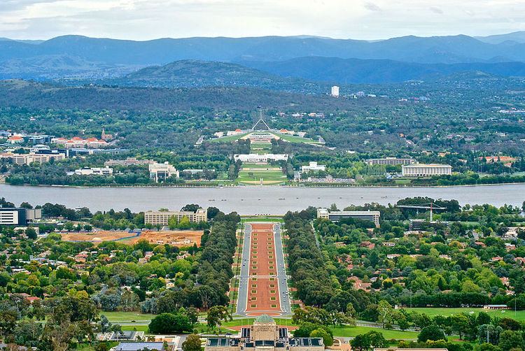
Canberra is a planned city and the inner-city area was originally designed by Walter Burley Griffin, a major 20th-century American architect. Within the central area of the city near Lake Burley Griffin, major roads follow a wheel-and-spoke pattern rather than a grid. Griffin's proposal had an abundance of geometric patterns, including concentric hexagonal and octagonal streets emanating from several radii. However, the outer areas of the city, built later, are not laid out geometrically.
Lake Burley Griffin was deliberately designed so that the orientation of the components was related to various topographical landmarks in Canberra. The lakes stretch from east to west and divided the city in two; a land axis perpendicular to the central basin stretches from Capital Hill—the eventual location of the new Parliament House on a mound on the southern side—north northeast across the central basin to the northern banks along Anzac Parade to the Australian War Memorial. This was designed so that looking from Capital Hill, the War Memorial stood directly at the foot of Mount Ainslie. At the southwestern end of the land axis was Bimberi Peak, the highest mountain in the ACT, approximately 52 km (32 mi) south west of Canberra.
The straight edge of the circular segment that formed the central basin of Lake Burley Griffin was perpendicular to the land axis and designated the water axis, and it extended northwest towards Black Mountain. A line parallel to the water axis, on the northern side of the city, was designated the municipal axis. The municipal axis became the location of Constitution Avenue, which links City Hill in Civic Centre and both Market Centre and the Defence precinct on Russell Hill. Commonwealth Avenue and Kings Avenue were to run from the southern side from Capital Hill to City Hill and Market Centre on the north respectively, and they formed the western and eastern edges of the central basin. The area enclosed by the three avenues was known as the Parliamentary Triangle, and formed the centrepiece of Griffin's work.
The Griffins assigned spiritual values to Mount Ainslie, Black Mountain, and Red Hill and originally planned to cover each of these in flowers. That way each hill would be covered with a single, primary color which represented its spiritual value. This part of their plan never came to fruition, as World War I slowed construction and planning disputes led to Griffin's dismissal by Prime Minister Billy Hughes after the war ended.
The urban areas of Canberra are organised into a hierarchy of districts, town centres, group centres, local suburbs as well as other industrial areas and villages. There are seven residential districts, each of which is divided into smaller suburbs, and most of which have a town centre which is the focus of commercial and social activities. The districts were settled in the following chronological order:
The Canberra Central district is substantially based on Walter Burley Griffin's designs. In 1967 the then National Capital Development Commission adopted the "Y Plan" which laid out future urban development in Canberra around a series of central shopping and commercial area known as the 'town centres' linked by freeways, the layout of which roughly resembled the shape of the letter Y, with Tuggeranong at the base of the Y and Belconnen and Gungahlin located at the ends of the arms of the Y.
Development in Canberra has been closely regulated by government, both through planning processes and the use of crown lease terms that have tightly limited the use of parcels of land. Land in the ACT is held on 99-year crown leases from the national government, although most leases are now administered by the Territory government. There have been persistent calls for constraints on development to be liberalised.
Many of Canberra's suburbs are named after former Prime Ministers, famous Australians, early settlers, or use Aboriginal words for their title. Street names typically follow a particular theme; for example, the streets of Duffy are named after Australian dams and reservoirs, the streets of Dunlop are named after Australian inventions, inventors and artists and the streets of Page are named after biologists and naturalists. Most diplomatic missions are located in the suburbs of Yarralumla, Deakin and O'Malley. There are three light industrial areas: the suburbs of Fyshwick, Mitchell and Hume.
Governance
Outside Canberra, the Australian Capital Territory has no settlements larger than a village. The Australian Capital Territory Legislative Assembly performs the roles of both a city council and territory government. The assembly consists of 25 members, elected from five districts using proportional representation. The five districts are Brindabella, Ginninderra, Kurrajong, Murrumbidgee and Yerrabi, which each elect five members.
The Chief Minister is elected by the Members of the Legislative Assembly (MLA) and selects colleagues to serve as ministers alongside him or her in the Executive, known informally as the cabinet. Whereas the ACT has federally been dominated by Labor, the Liberals have been able to gain some footing in the ACT Legislative Assembly, and were in government for just over eight of the Assembly's 25-year history, mostly during a period of six and half years from 1995 and 2001, when Labor won power. At the 2004 election the Australian Labor Party, headed by then Chief Minister Jon Stanhope, won nine of the 17 seats and formed the ACT's first majority government, but after the 2008 election was forced into minority government with the support of the Greens. Since the 2012 elections, the ACT has been governed by a coalition of Labor and the Greens.
As almost all of the ACT's population lives in Canberra, political trends for both areas are closely aligned. The ACT was given its first federal parliamentary representation in 1949, when it gained a seat in the House of Representatives, the Division of Australian Capital Territory. The ACT member could only vote on matters directly affecting the territory. In 1974, the ACT was allocated two Senate seats. In 1974, the House of Representatives seat was divided into two. A third was created in 1996, but was abolished in 1998 because of changes to the regional demographic distribution.
Both House of Representatives seats have mostly been held by Labor, usually by comfortable margins. The Labor Party has polled at least seven percentage points more than the Liberal Party at every federal election since 1990, and their average lead since then has been 15 percentage points. The ALP and the Liberal Party have always held one Senate seat each.
The Australian federal government retains some influence over the ACT government. In the administrative sphere, most frequently this is through the actions of the National Capital Authority which is responsible for planning and development in areas of Canberra which are considered to be of national importance or which are central to Griffin's plan for the city, such as the Parliamentary Triangle, Lake Burley Griffin, major approach and processional roads, areas where the Commonwealth retains ownership of the land or undeveloped hills and ridge-lines (which form part of the Canberra Nature Park). The national government also retains a level of control over the Territory Assembly through the provisions of the Australian Capital Territory (Self-Government) Act 1988. This federal act defines the legislative power of the ACT assembly.
The Australian Federal Police (AFP) provides all of the constabulary services in the territory in a manner similar to state police forces, under a contractual agreement with the ACT Government. The AFP does so through its community policing arm, ACT Policing (Australian Capital Territory Police).
People who have been charged with offences are tried either in the ACT Magistrates Court or for more severe offences, the ACT Supreme Court. Prior to its closure in 2009, prisoners were held in remand at the Belconnen Remand Centre in the ACT but usually gaoled in New South Wales. The Alexander Maconochie Centre was officially opened on 11 September 2008 by then Chief Minister Jon Stanhope. The total cost for construction was $130 million. Courts such as a Small Claims Tribunal and a Family Court exist for civil law actions and other non-criminal legal matters.
Economy
In May 2012, the unemployment rate in Canberra was 3.4% which was lower than the national unemployment rate of 5.1%. As a result of low unemployment and substantial levels of public sector and commercial employment, Canberra has the highest average level of disposable income of any Australian capital city. The gross average weekly wage in Canberra is $1702 compared with the national average of $1485.80 (May 2013).
The median house price in Canberra as of September 2009 was $511,820, lower than only Sydney among capital cities of more than 100,000 people, having surpassed Melbourne and Perth since 2005. The median weekly rent paid by Canberra residents is higher than rents in all other states and territories. As at January 2014 the median unit rent in Canberra was $410 per week and median housing rent was $460, making the city the third most expensive in the country. Factors contributing to this higher weekly rental market include; higher average weekly incomes, restricted land supply, and inflationary clauses in the ACT Residential Tenancies Act.
The city's main industry is public administration and safety, which accounted for 29.8% of Gross Territory Product in 2011–12 and employed 33.9% of Canberra's workforce. The headquarters of many Australian Public Service agencies are located in Canberra, and Canberra is also host to several Australian Defence Force establishments, most notably the Australian Defence Force headquarters and HMAS Harman, which is a naval communications centre that is being converted into a tri-service, multi-user depot.
The former RAAF Fairbairn, adjacent to the Canberra Airport was sold to the operators of the airport, but the base continues to be used for RAAF VIP flights. A growing number of software vendors have based themselves in Canberra, to capitalise on the concentration of government customers; these include Tower Software and RuleBurst. A consortium of private and government investors is currently making plans for a billion-dollar data hub, with the aim of making Canberra a leading centre of such activity in the Asia-Pacific region.
Sustainability and environment
The average Canberran was responsible for 13.7 tonnes of greenhouse gases in 2005. In 2012 the ACT Government legislated greenhouse gas targets to reduce its emissions by 40 per cent from 1990 levels by 2020, 80 per cent by 2050, with no net emissions by 2060. The government announced in 2013 a target for 90% of electricity consumed in the ACT to be supplied from renewable sources by 2020, and in 2016 set an ambitious target target of 100% by 2020.
In 1996 Canberra became the first city in the world to set a vision of no waste, proposing an ambitious target of 2010 for completion. The strategy aimed to achieve a waste-free society by 2010, through the combined efforts of industry, government and community. By early 2010, it was apparent that though it had reduced waste going to landfill, the ACT initiative's original 2010 target for absolutely zero landfill waste would be delayed or revised to meet the reality.
Plastic bags made of polyethylene polymer with a thickness of less than 35 µm were banned from retail distribution in the ACT from November 2011. The ban was introduced by the ACT Government in an effort to make Canberra more sustainable.
Of all waste produced in the ACT, 75 per cent is recycled. Average household food waste in the ACT remains above the Australian average, costing an average $641 per household per annum.
Canberra's annual Floriade festival features a large display of flowers every Spring in Commonwealth Park. The organisers of the event have a strong environmental standpoint, promoting and using green energy, "green catering", sustainable paper, the conservation and saving of water. The event is also smoke-free.
Demographics
As at census night in August 2011, the population of Canberra was 355,596, up from 323,056 people in 2006. The 2011 census showed Aboriginal and Torres Strait Islander people made up 1.4% of ACT's population, while 28.6% of the population were born overseas. The largest group of people born overseas came from the United Kingdom (3.7%) and then China (1.8%).
Significant numbers of immigrants have also come from New Zealand, India and Vietnam. Recent immigrants have arrived from countries in East and South Asia. Most locals only speak English at home (77.8%); other languages spoken at home include Mandarin, Italian, Vietnamese, Cantonese and Spanish.
Canberrans are relatively young, highly mobile, and well educated. The median age is 34 years, and only 10.7% of the population is aged over 65 years. Between 1996 and 2001, 61.9% of the population either moved to or from Canberra, which was the second highest mobility rate of any Australian capital city. According to statistics collected by the National Australia Bank and reported in The Canberra Times, Canberrans on average give significantly more money to charity than Australians in other states and territories, for both dollar giving and as a proportion of income.
As at May 2013, 45% of ACT residents (25–64) had a level of educational attainment equal to at least a bachelor's degree, significantly higher that the national average of 29%. On census night in 2011, approximately 44% of ACT residents described themselves as Christian, the most common denominations being Catholic and Anglican; 29% described themselves as having no religion.
As of 2012 the most common crimes in the ACT are property related crimes, unlawful entry with intent and motor vehicle theft. They affected 2,386 and 968 people (637 and 258 per 100,000 persons respectively). Homicide and related offences—murder, attempted murder and manslaughter, but excluding driving causing death and conspiracy to murder—affect 1.6 per 100,000 persons, which is below the national average of 2.0 per 100,000. Rates of assault and sexual assault (60.2 per 100,000 persons) are also below the national average (80.2 per 100,000).
Education
The two main tertiary institutions are the Australian National University (ANU) in Acton and the University of Canberra (UC) in Bruce, with over 10,500 and 8,000 full-time-equivalent students respectively. Established in 1946, the ANU has always had a strong research focus and is ranked among the leading universities in the world and the best in Australia by The Times Higher Education Supplement and the Shanghai Jiao Tong World University Rankings. There are two religious university campuses in Canberra: Signadou in the northern suburb of Watson is a campus of the Australian Catholic University; St Mark's Theological College in Barton is part of the secular Charles Sturt University.
The Australian Defence Force Academy (ADFA) and the Royal Military College, Duntroon are located in the inner-northern suburb of Campbell. ADFA teaches military undergraduates and postgraduates and includes UNSW@ADFA, a campus of the University of New South Wales; Duntroon provides Australian Army officer training. Tertiary level vocational education is also available through the multi-campus Canberra Institute of Technology.
In 2016 there were 132 schools in Canberra; 87 were operated by the government and 45 were private. During 2006, the ACT Government announced closures of up to 39 schools, to take effect from the end of the school year, and after a series of consultations unveiled its Towards 2020: Renewing Our Schools policy. As a result, some schools closed during the 2006–08 period, while others were merged; the creation of combined primary and secondary government schools will proceed over the next decade. The new policy has provoked significant opposition. Most suburbs are planned to include a primary and a nearby preschool; these are usually located near open areas where recreational and sporting activities are easily available. Canberra also has the highest percentage of non-government (private) school students in Australia, accounting for 40.6 per cent of ACT enrollments.
Arts and entertainment
Canberra is home to many national monuments and institutions such as the Australian War Memorial, the National Gallery of Australia, the National Portrait Gallery, the National Library, the National Archives, the Australian Academy of Science, the National Film and Sound Archive and the National Museum. Many Commonwealth government buildings in Canberra are open to the public, including Parliament House, the High Court and the Royal Australian Mint.
Lake Burley Griffin is the site of the Captain James Cook Memorial and the National Carillon. Other sites of interest include the Telstra Tower, the Australian National Botanic Gardens, the National Zoo and Aquarium, the National Dinosaur Museum and Questacon – the National Science and Technology Centre.
The Canberra Museum and Gallery in the city is a repository of local history and art, housing a permanent collection and visiting exhibitions. Several historic homes are open to the public: Lanyon and Tuggeranong Homesteads in the Tuggeranong Valley, Mugga-Mugga in Symonston, and Blundells' Cottage in Parkes all display the lifestyle of the early European settlers. Calthorpes' House in Red Hill is a well-preserved example of a 1920s house from Canberra's very early days. Canberra has many venues for live music and theatre: the Canberra Theatre and Playhouse which hosts many major concerts and productions; and Llewellyn Hall (within the ANU School of Music), a world-class concert hall are two of the most notable. The Street Theatre is a venue with less mainstream offerings. The Albert Hall was the city's first performing arts venue, opened in 1928. It was the original performance venue for theatre groups such as the Canberra Repertory Society.
Stonefest was a large annual festival, for some years one of the biggest festivals in Canberra. It was downsized and rebranded as Stone Day in 2012. There are numerous bars and nightclubs which also offer live entertainment, particularly concentrated in the areas of Dickson, Kingston and the city. Most town centres have facilities for a community theatre and a cinema, and they all have a library. Popular cultural events include the National Folk Festival, the Royal Canberra Show, the Summernats car festival, Enlighten festival, the National Multicultural Festival in February and the Celebrate Canberra festival held over 10 days in March in conjunction with Canberra Day.
Canberra maintains sister-city relationships with both Nara, Japan and Beijing, China. Canberra has friendship-city relationships with both Dili, East Timor and Hangzhou, China. City-to-city relationships encourage communities and special interest groups both locally and abroad to engage in a wide range of exchange activities. The Canberra Nara Candle Festival held annually in spring, is a community celebration of the Canberra Nara Sister City relationship. The festival is held in Canberra Nara Park on the shores of Lake Burley Griffin.
Media
As Australia's capital, Canberra is the most important centre for much of Australia's political reportage and thus all the major media, including the Australian Broadcasting Corporation, the commercial television networks, and the metropolitan newspapers maintain local bureaus. News organisations are represented in the "press gallery", a group of journalists who report on the national parliament. The National Press Club of Australia in Barton has regular television broadcasts of its lunches at which a prominent guest, typically a politician or other public figure, delivers a speech followed by a question-and-answer session.
Canberra has a daily newspaper, The Canberra Times, which was established in 1926. There are also several free weekly publications, including news magazines CityNews and Canberra Weekly as well as entertainment guide BMA Magazine. BMA Magazine first went to print in 1992; the inaugural edition featured coverage of the Nirvana Nevermind tour.
Radio
There are a number of AM and FM stations broadcasting in Canberra (AM/FM Listing). The main commercial operators are the Capital Radio Network (2CA and 2CC), and Austereo/ARN (104.7 and Mix 106.3). There are also several community operated stations.
A DAB+ digital radio trial is also currently in operation, it simulcasts some of the AM/FM stations, and also provides several digital only stations (DAB+ Trial Listing).
Television
Five free-to-air television stations service Canberra:
Each station broadcasts a primary channel and several multichannels.
Prior to 1989, Canberra was serviced by just the ABC, SBS and Capital Television (CTC), which later became Southern Cross Nine, with Prime Television (now Prime7) and WIN Television arriving as part of the Government's regional aggregation programme in that year.
Pay television services are available from Foxtel (via satellite) and telecommunications company TransACT (via cable).
Sport
In addition to local sporting leagues, Canberra has a number of sporting teams that compete in national and international competitions. The best known teams are the Canberra Raiders and the Brumbies who play rugby league and rugby union respectively; both have been champions of their leagues. Both teams play their home games at Canberra Stadium, which is the city's largest stadium and was used to hold group matches in soccer for the 2000 Summer Olympics and in rugby union for the 2003 Rugby World Cup. The city also has a successful basketball team, the Canberra Capitals, which has won seven out of the last eleven national women's basketball titles. Canberra United FC represents the city in the W-League, the national women's association football league, and were champions in the 2011–12 season. The Canberra Vikings represent the city in the National Rugby Championship and finished second in the 2015 season.
There are also teams that participate in national competitions in netball, field hockey, ice hockey, cricket and baseball. Manuka Oval is another large outdoor sporting facility where cricket and Australian Rules football are played.
Expansion AFL club Greater Western Sydney Giants commenced a partnership with Canberra in 2012 will play three home games at Manuka Oval each season until at least 2021. Prior to this the Melbourne-based AFL team the Kangaroos played some home games at Manuka Oval until July 2006. Following the move of the Kangaroos' alternative home ground to Carrara in Queensland, Melbourne and the Western Bulldogs played some home games at Manuka Oval from 2007 against the Sydney Swans. Canberra is also home to the Barassi International Australian Football Youth Tournament. The historic Prime Minister's XI cricket match is played at Manuka Oval annually. Other significant annual sporting events include the Canberra Marathon and the City of Canberra Half Ironman Triathlon.
The Australian Institute of Sport (AIS) is located in the Canberra suburb of Bruce. The AIS is a specialised educational and training institution providing coaching for elite junior and senior athletes in a number of sports. The AIS has been operating since 1981 and has achieved significant success in producing elite athletes, both local and international. The majority of Australia's team members and medallists at the 2000 Summer Olympics in Sydney were AIS graduates.
Canberra has numerous sporting ovals, golf courses, skate parks, and swimming pools that are open to the public. Tennis courts include those at the National Sports Club, Lyneham, former home of the Canberra Women's Tennis Classic. A Canberra-wide series of bicycle paths are available to cyclists for recreational and sporting purposes. Canberra Nature Parks have a large range of walking paths, horse and mountain bike trails. Water sports like sailing, rowing, dragon boating and water skiing are held on Canberra's lakes. The Rally of Canberra is an annual motor sport event and a facility for drag racing is currently being planned for construction. From 2000 to 2002, Canberra hosted the Canberra 400 event for V8 Supercars on the temporary Canberra Street Circuit, which was located inside the Parliamentary Triangle.
Health
Canberra has two large public hospitals, the approximately 600-bed Canberra Hospital—formerly the Woden Valley Hospital—in Garran and the 174-bed Calvary Public Hospital in Bruce. Both are teaching institutions. The largest private hospital is the Calvary John James Hospital in Deakin. Calvary Private Hospital in Bruce and Healthscope's National Capital Private Hospital in Garran are also major healthcare providers.
The Royal Canberra Hospital was located on Acton Peninsula on Lake Burley Griffin; it was closed in 1991 and was demolished in 1997 in a controversial and fatal implosion to facilitate construction of the National Museum of Australia. The city has 10 aged care facilities. Canberra's hospitals receive emergency cases from throughout southern New South Wales, and ACT Ambulance Service is one of four operational agencies of the ACT Emergency Services Authority. NETS provides a dedicated ambulance service for inter-hospital transport of sick newborns within the ACT and into surrounding New South Wales.
Transport
The automobile is by far the dominant form of transport in Canberra. The city is laid out so that arterial roads connecting inhabited clusters run through undeveloped areas of open land or forest, which results in a low population density; this also means that idle land is available for the development of future transport corridors if necessary without the need to build tunnels or acquire developed residential land. In contrast, other capital cities in Australia have substantially less green space.
Canberra's districts are generally connected by parkways—limited access dual carriageway roads with speed limits generally set at a maximum of 100 km/h (62 mph). An example is the Tuggeranong Parkway which links Canberra's CBD and Tuggeranong, and bypasses Weston Creek. In most districts, discrete residential suburbs are bounded by main arterial roads with only a few residential linking in, to deter non-local traffic from cutting through areas of housing.
In an effort to improve road safety, traffic cameras were first introduced to Canberra by the Carnell Government in 1999. The traffic cameras installed in Canberra include fixed red-light and speed cameras and point-to-point speed cameras; together they bring in revenue of approximately $11 million per year in fines.
ACTION, the government-operated bus service, provides public transport throughout the city. Qcity Transit provides bus services between Canberra and nearby areas of New South Wales through their Transborder Express brand (Murrumbateman and Yass) and as Qcity Transit (Queanbeyan). A light rail line is under construction. It will link the CBD with the northern district of Gungahlin. In the 2011 census, 6.7% of the journeys to work involved public transport; with 6.5% walking or cycling to work.
There are two local taxi companies. Aerial Capital Group enjoyed monopoly status until the arrival of Cabxpress in 2007. In October 2015 the ACT Government passed legislation to regulate ride sharing, allowing ride share services including Uber to operate legally in Canberra. The ACT Government was the first jurisdiction in Australia to enact legislation to regulate the service.
An interstate NSW TrainLink railway service connects Canberra to Sydney. Canberra's railway station is in the inner south suburb of Kingston. Between 1920 and 1922 the train line crossed the Molonglo River and ran as far north as the city centre, although the line was closed following major flooding and was never rebuilt, while plans for a line to Yass were abandoned. A 3 ft 6 in (1,067 mm) gauge construction railway was built in 1923 between the Yarralumla brickworks and the provisional Parliament House; it was later extended to Civic, but the whole line was closed in May 1927. Train services to Melbourne are provided by way of a NSW TrainLink bus service which connects with a rail service between Sydney and Melbourne in Yass, about a one-hour drive from Canberra.
Plans to establish a high-speed rail service between Melbourne, Canberra and Sydney, have not been implemented, as the various proposals have been deemed economically unviable. The original plans for Canberra included proposals for railed transport within the city, however none eventuated. The phase 2 report of the most recent proposal, the High Speed Rail Study, was published by the Department of Infrastructure and Transport on 11 April 2013. A railway connecting Canberra to Jervis Bay was also planned but never constructed.
Canberra is about three hours by road from Sydney on the Federal Highway (National Highway 23), which connects with the Hume Highway (National Highway 31) near Goulburn, and seven hours by road from Melbourne on the Barton Highway (National Highway 25), which joins the Hume Highway at Yass. It is a two-hour drive on the Monaro Highway (National Highway 23) to the ski fields of the Snowy Mountains and the Kosciuszko National Park. Batemans Bay, a popular holiday spot on the New South Wales coast, is also two hours away via the Kings Highway.
Canberra Airport provides direct domestic services to Sydney, Melbourne, Brisbane, Adelaide, Gold Coast and Perth, with connections to other domestic centres. There are also direct flights to small regional towns: Dubbo and Newcastle in New South Wales. Regular commercial international flights operate to Singapore and Wellington from the airport four times a week. Canberra Airport is, as of September 2013, designated by the Australian Government Department of Infrastructure and Regional Development as a restricted use designated international airport. Until 2003 the civilian airport shared runways with RAAF Base Fairbairn. In June of that year, the Air Force base was decommissioned and from that time the airport was fully under civilian control.
Canberra has one of the highest rates of active travel of all Australian major cities, with 7.1 per cent of commuters walking or cycling to work in 2011. An ACT Government survey conducted in late 2010 found that Canberrans walk an average of 26 minutes each day. According to The Canberra Times in March 2014, Canberra's cyclists are involved in an average of four reported collisions every week. The newspaper also reported that Canberra is home to 87,000 cyclists, translating to the highest cycling participation rate in Australia; and, with higher popularity, bike injury rates in 2012 were twice the national average.
Utilities
The government-owned ACTEW Corporation manages Canberra's water and sewerage infrastructure. ActewAGL is a joint venture between ACTEW and AGL, and is the retail provider of Canberra's utility services including water, natural gas, electricity, and also some telecommunications services via a subsidiary TransACT.
Canberra's water is stored in four reservoirs, the Corin, Bendora and Cotter dams on the Cotter River and the Googong Dam on the Queanbeyan River. Although the Googong Dam is located in New South Wales, it is managed by the ACT government. ACTEW Corporation owns Canberra's two wastewater treatment plants, located at Fyshwick and on the lower reaches of the Molonglo River.
Electricity for Canberra mainly comes from the national power grid through substations at Holt and Fyshwick (via Queanbeyan). Power was first supplied from a thermal plant built in 1913, near the Molonglo River, but this was finally closed in 1957. A 20 megawatt photovoltaic solar plant, described as the largest photovoltaic solar farm in Australia, was officially opened at Royalla on 3 September 2014. The 2.3 megawatt Mount Majura solar farm was opened in Majura on 6 October 2016. Construction is under way on a 13 megawatt solar farm at Mugga Lane, Hume and an 11 megawatt solar farm at Williamsdale. The Williamsdale solar farm was originally planned to be built at Uriarra but faced local opposition. In addition numerous houses in Canberra have photovoltaic panels and/or solar hot water systems. Some limited local renewable power is produced via a hydro generator on the main water supply pipeline for Canberra at Mount Stromlo and methane plants at waste landfill sites at Belconnen and Mugga Lane. There are currently no wind-power generators in Canberra, but several have been built or are being built or planned in nearby New South Wales, such as the 140.7 megawatt Capital Wind Farm. The ACT government announced in 2013 that it was raising the target for electricity consumed in the ACT to be supplied from renewable sources to 90% by 2020. This will raise the target from 210 to 550 megawatts. It announced in February 2015 that three wind farms in Victoria and South Australia would supply 200 megawatts of capacity; these are expected to be operational by 2017. Contracts for the purchase of an additional 200 megawatts of power per year from two wind farms in South Australia and New South Wales were announced in December 2015 and March 2016. The ACT government announced in 2014 that up to 23 megawatts of feed-in-tariff entitlements would be made available for the establishment of a facility in the ACT or surrounding region for burning household and business waste to produce electricity by 2020.
The ACT has the highest rate with internet access at home (94 per cent of households in 2014–15).
Twin towns – sister cities
Canberra is twinned with: