
 | ||
- average 767 m/s (27,086 cu ft/s) | ||
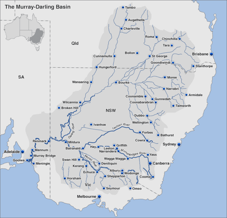
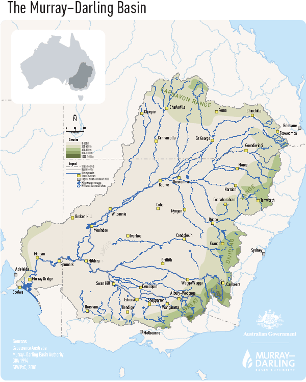
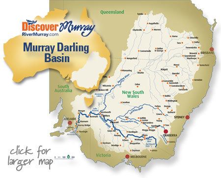
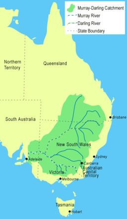
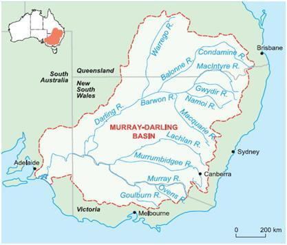
The Murray–Darling basin is a large geographical area in the interior of southeastern Australia. Its name is derived from its two major rivers, the Murray River and the Darling River. The basin, which drains around one-seventh of the Australian land mass, is one of the most significant agricultural areas in Australia. It spans most of the states of New South Wales, Victoria, and the Australian Capital Territory, and parts of the states of Queensland (lower third) and South Australia (southeastern corner). The basin is 3,375 kilometres (2,097 mi) in length, with the Murray River being 2,508 km (1,558 mi) long.
Contents
- Native fauna
- Introduced species
- Physiography
- Management
- The MurrayDarling Basin plan
- History
- Sustainability and risks
- References
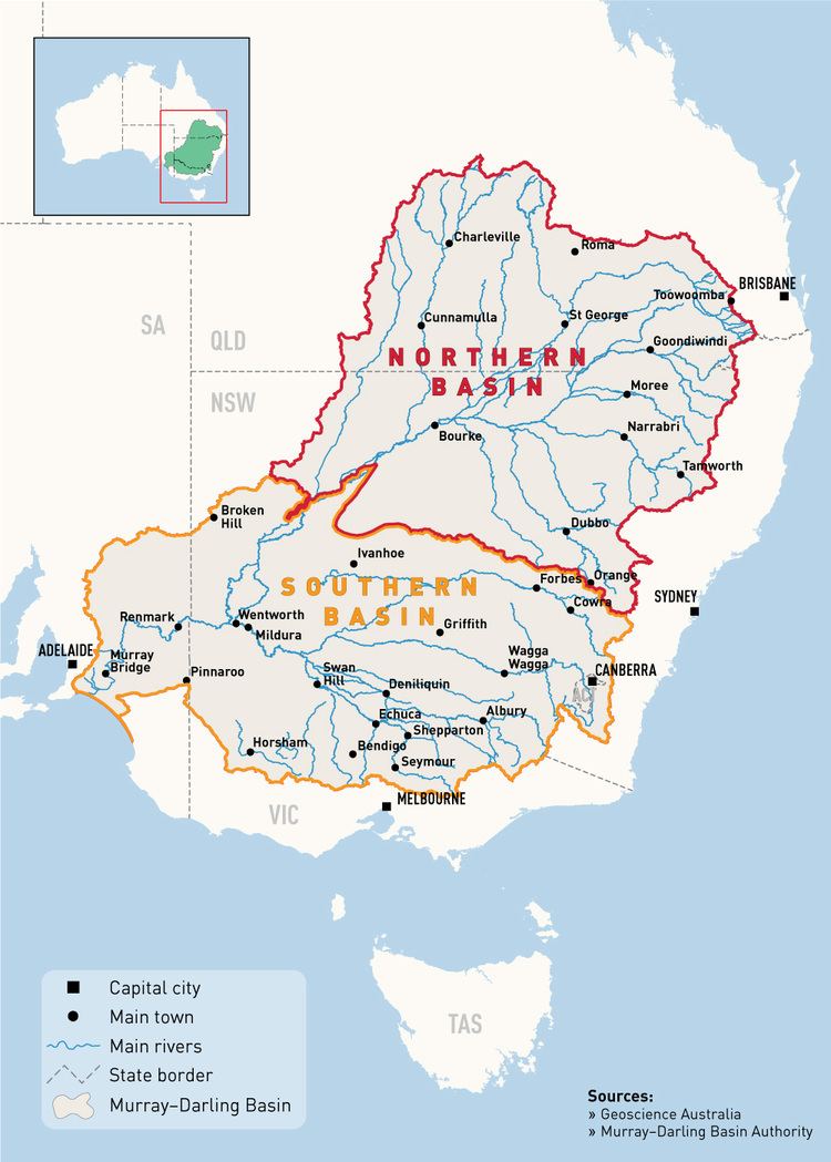
Most of the 1,061,469 km2 (409,835 sq mi) basin is flat, low-lying and far inland, and receives little direct rainfall. The many rivers it contains tend to be long and slow-flowing, and carry a volume of water that is large only by Australian standards.
Native fauna
The Murray–Darling basin is home to many native animal species. The true numbers may not be known, but a fairly confident estimate has been made of these animals and the current status of their population. Among the aboriginal fauna in the region, the study found that there were:
Historical records show that the previous abundances of fish provided a reliable food source. The bountiful fish became concentrated when the early stages of a flood left shallow water across the floodplain. Today, roughly 24 native freshwater fish and another 15-25 marine and estuarine species are existent in the basin, a very low biodiversity.
Introduced species
Four varieties of carp were used to stock up fish dams. Since then they have made their way into the river systems, where they spread quite quickly. Human introduction, possibly by anglers using small carp illegally as live bait has also increased their distribution. These fish are very mobile, as they can travel easily on flood waters and their eggs can be transported by birds.
Carp are a problem because they feed by sucking gravel from the river bed and taking all the edible material off it, before returning the rest to the water. This stirs up all the sediment, reducing the quality of the water. When caught by fishermen, carp must be killed by law. A project for developing daughterless carp shows promise for eliminating carp from the river system.
Cane toads have entered the upper reaches of the Darling Basin and there are several reports of individuals being found further down the system. Cane toads compete with native amphibians and are toxic to native carnivores.
Physiography
This area is one of the physiographic provinces of the larger East Australian basins division, and encompasses the smaller Naracoorte Platform and Encounter Shelf physiographic sections.
Total water flow in the Murray–Darling basin 1885 to the present has averaged around 24,000 gigalitres (24 km3; 19,000,000 acre·ft) per year. This is the lowest rate of the world's major river systems. About 6.0 percent of Australia's total rainwater falls into the basin. In most years only half of this quantity reaches the sea and in dry years much less. Estimated total annual flows for the basin have ranged from 5,000 gigalitres (5.0 km3; 4,100,000 acre·ft) in 1902 to 57,000 gigalitres (57 km3; 46,000,000 acre·ft) in 1956. Despite the magnitude of the basin, the hydrology of the streams within it is quite varied.
These waters are divided into four types:
The two principal rivers of the basin, the Murray and Darling, bring water from the high ranges of the east and carry it west then south through long flat and dry in lands. Nevertheless, these waters are subject to major diversions for municipal drinking supplies and irrigated agriculture that began in the 1890s. Currently, 4 major reservoirs, 14 lock and weir structures, and five coastal barrages interject the water flowing down the Murray-Darling. Of the approximately 13,000 gigalitres (13.0 km3; 10,500,000 acre·ft) of flow in the basin, which studies have shown to be divertible, 11,500 gigalitres (11.5 km3; 9,320,000 acre·ft) are removed for irrigation, industrial use, and domestic supply. Agricultural irrigation accounts for about 95 percent of the water removed, including for the growing of rice and cotton. This extraction is highly controversial among scientists in Australia, regarding the agriculture industry's high water use in a region extremely short of water (as much due to exceptionally low run-off coefficients as to low rainfall). These extensive irrigation systems require a reliable supply of water, not the unpredictable flows that characterize the Murray-Darling. These structures and irrigation implements were ideal when there was a steady flow of water. However, during “the Big Dry,” as the drought came to be known, Australian farmers experienced a scarcity unlike every before. The drought was so severe that numerous rivers and streams such as the Murray-Darling stopped flowing. The basin contains more than 30,000 wetlands. Eleven of these are protected under the Ramsar Convention of Wetlands of International Importance.
The rivers listed below comprise the Murray–Darling basin and its direct significant tributaries, with elevations of their confluence with the downstream river. The tributary with the highest elevation is Swampy Plain River that rises in the Snowy Mountains, below Mount Kosciuszko at an elevation of 2,120 metres (6,960 ft), and ends merging with the Murray River, descending 1,860 metres (6,100 ft).
The ordering of the basin, from downstream to upstream, is:
Management
The basin covers five states and territory governments, who according to the Constitution, are responsible for managing water resources. The River Murray Commission was established in 1917. Under the River Murray Waters Agreement, which never included Queensland despite the state containing about a quarter of the basin, the Commission's role was only as an advisory body with no authority for the enforcement of provisions. For a long time the Commission was only concerned with water quantity until salinity became a problem. This led to minor reforms in 1982 in which water quality became part of the Commission's responsibilities. However, it was soon recognised that a new organisational structure which considered the national perspective was needed for effective management.
The Murray–Darling Basin Agreement was first adopted in 1985 but it wasn't until 1993 that its full legal status was enacted. The Agreement led to the creation of a number of new organisations under what is known as the Murray-Darling Basin Initiative. These included the Murray-Darling Basin Ministerial Council and the Murray Darling Basin Commission.
The Murray–Darling Basin plan
The Murray-Darling Basin Plan was signed off by Tony Burke, Minister for Sustainability, Environment, Water, Population and Communities on 22 November 2012, and passed disallowance period in the Australian Parliament on the 19 March 2013. Following is the history leading up to this significant occasion in the history of Australian water reform.
History
In October 2010, in response to the 2000s Australian drought, the Murray–Darling Basin Authority released a draft plan to secure the long-term ecological health of the Murray–Darling Basin. This entailed cutting existing water allocations and increasing environmental flows. The document is officially titled the Guide to the Proposed Murray–Darling Basin Plan. It is the first part of a three-stage process to address the problems of the Murray–Darling Basin. MDBA is responsible for preparing and overseeing a legally-enforceable management plan — the Basin Plan.
The Basin Plan is designed to set environmentally sustainable limits on the quantities of water that may be taken from Basin water resources, to set Basin-wide environmental, water quality and salinity objectives, to develop efficient water trading regimes across the Basin, to set requirements for state water resource plans and to improve water security for all Basin users. It also intends to minimise social and economic impacts whilst achieving the plan's environmental outcomes.
With the release of the Guide to the Proposed Murray–Darling Basin Plan there have been a number of protests and voiced concerns about the plan in rural towns that the MDBA visited to present the plan to consultation meetings. More than 5,000 people attended a MDBA meeting in Griffith where Griffith Mayor, Mike Neville, said the plan would "obliterate" Murrumbidgee valley communities. Other groups also echo this feeling, such as the Victorian Farmers Federation and Wine Group Growers' Australia. Conversely, support for the Murray–Darling Basin plan has been received by various groups, including Australian Conservation Foundation, and Environment Victoria.
New legal advice from the lawyers of the Federal Government is changing the plan. The Government's interpretation is that the plan must give equal weight to the environmental, social, and economic impacts of proposed cuts to irrigation.
Environmentalists and South Australian irrigators, at the end of the river in South Australia, say that the authority should stick to its original figure.
In October 2010, a parliamentary inquiry into the economic impacts of the plan was announced.
In late October 2010 the Water Minister, Tony Burke, played down the prospect of a High Court challenge to the Murray–Darling Basin plan, as confusion continued over new legal advice released by the Government. In response to community concerns that the Murray–Darling Basin Authority had put environmental issues first over social and economic needs, Burke released new advice on the requirements of the Water Act. Burke stated that the Act does allow for the authority to "optimise" the needs of all three areas, but constitutional lawyer, George Williams, had cast doubts over the interpretation of the laws, stating it could be subject to a legal challenge.
The MDBA announced in November 2010 that it might be forced to push back the release of its final plan for the river system until early 2012.
The then MDBA chairman, Mike Taylor, reassured the public meeting that more work is being done to look at how the proposed cuts would affect regional communities. He stated; "Importantly, we want to make sure the social and economic impacts—which under any sort of scenario is very significant—were fully teased out". Taylor resigned as he allegedly believed that the overriding principle should be the environmental outcome which was in conflict with the Gillard Government and following a period of sustained criticism of the Authority and the implementation of the proposed draft basin plan. He was replaced by former New South Wales Planning Minister, Craig Knowles.
In late May 2012, the revised plan was forwarded to state water ministers. It did not alter the recommendation to cut 2,750 gigalitres (2.75 km3; 2,230,000 acre·ft) of water entitlements.
Following much negotiation between the Commonwealth and State governments and numerous submissions from interested stakeholders and the community, the Basin Plan became law in November 2012 and can now be implemented.
Sustainability and risks
Although the Murray-Darling Basin Plan (MDBP) is a positive step towards sustainability the measures keep a significant risk of human activities exacerbating the drought risk (see River Murray which has only dried up twice since records began). The Environmental Water Requirement found that a reduction in allocations of 7,600 GL (7.60 km3; 6,160,000 acre·ft) (per year) is required to be certain that the river systems would maintain their health. However objectors cite socio-economic impacts of major cutbacks to the widescale farming (and in some areas wine-growing) in the basin, and conclude that within plans for population growth, particularly in times of drought, may be a need for sustainable water transportation from new extraction from rivers in the wettest part of the country, the Cape York Peninsula or more desalination.