
Length 3,517 km | ||
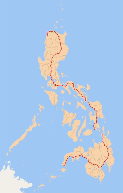 | ||
Componenthighways: Daang Maharlika from Laoag to Lal-loCagayan Valley Road from Lal-lo to Guiguinto North Luzon Expressway from Guiguinto to Balintawak, Quezon City EDSA around Metro Manila South Luzon Expressway from Magallanes Interchange to Calamba Daang Maharlika/Manila South Road from Calamba to MatnogDaang Maharlika through Northern Samar, Samar, Leyte, and Southern Leyte Daang Maharlika from Surigao City to Davao CityCarlos P. Garcia Highway over Davao City Daang Maharlika/MacArthur Highway from Davao City to Davao City-Davao del Sur boundary Daang Maharlika from Davao City-Davao del Sur boundary to General Santos City Daang Maharlika from General Santos City to Zamboanga CitySpurs: Palo-Carigara-Ormoc Road from Palo to Ormoc Davao - Bukidnon Road and Sayre Highway from Davao City to Cagayan de OroAlternate route:C-4 Road from Caloocan to NavotasRoad 10 from Navotas to Del Pan BridgeBonifacio Drive from Del Pan Bridge to P. BurgosRoxas Boulevard from P. Burgos to EDSA EDSA from Roxas Boulevard to Magallanes Interchange North end: Laoag City, Ilocos Norte | ||
The Pan-Philippine Highway, also known as the Maharlika ("Nobility/freeman") Highway () is a 3,517 km (2,185 mi) network of roads, bridges, and ferry services that connect the islands of Luzon, Samar, Leyte, and Mindanao in the Philippines, serving as the country's principal transport backbone. It is the longest highway in the Philippines that forms the country's north–south backbone designated as N1 of the Philippine highway network.
Contents
Map of Pan-Philippine Hwy, Philippines
The northern terminus of the highway is in Laoag, Ilocos Norte, and the southern terminus is in Zamboanga City.
Development
The highway was proposed in 1965, and built under President Ferdinand Marcos's governance. Government planners believed that the motorway and other connected roads would stimulate agricultural production by reducing transport costs, encourage social and economic development outside existing major urban centres such as Manila, and expand industrial production for domestic and overseas markets. Construction was supported by loans and grants from foreign aid institutions, including the World Bank.
The highway was rehabilitated and improved in 1997 with assistance from the Japanese government, and dubbed the Philippine-Japan Friendship Highway. In 1998, the Department of Tourism designated 35 sections of the highway as "Scenic Highways", with developed amenities for travellers and tourists.
The future segment of Pan-Philippine Highway within Metro Manila is the Skyway Stage 3 from Balintawak, Quezon City to Buendia, Makati City including the existing portion of Skyway Stage 1 from Buendia to Magallanes. It will also serve as an alternate route for the motorists avoiding EDSA from North Luzon Expressway to South Luzon Expressway and vice versa.
Route
Main Route:
Alternative Route
Asian Highway Network
The Pan-Philippine Highway is designated as in the Asian Highway Network, a cooperative project which seeks to improve highway systems and standards across the continent. It is currently the only highway in the system that is isolated from every other highway; island-based sections of the Asian Highway Network in Japan (), Sri Lanka (AH43) and Indonesia () are all linked to the mainland sections by ferries to South Korea (), India (Dhanushkodi), and Singapore, respectively.