
Founded 1768 Time zone PST (UTC+8) Local time Tuesday 11:16 PM | Barangays Area 221.3 km² | |
 | ||
Weather 26°C, Wind S at 2 km/h, 91% Humidity University University of the Philippines Manila School of Health Sciences in Leyte Neighborhoods Candahug, Luntad, Cavite West, Anahaway | ||
Dry run for pope francis itinerary in tacloban city and palo leyte 1 14 2015
Palo is a 3rd class municipality in the province of Leyte, Philippines. According to the 2015 census, it has a population of 70,052 people.
Contents
- Dry run for pope francis itinerary in tacloban city and palo leyte 1 14 2015
- Map of Palo Leyte Philippines
- Geography
- History
- Demographics
- Economy
- Religion
- Private
- Public
- Tourist attractions
- Cultural Organizations
- References
Map of Palo, Leyte, Philippines
The municipality is the seat of most government departments, bureaus and regional offices of Region VIII, although some are situated at the neighboring city of Tacloban. The town is also home to the offices of the ecclesiastical government of the Archdiocese of Palo; the archbishop's residence; as well as the secondary, tertiary and theology seminaries of the archdiocese.
Geography
The municipality is located in the north-eastern part of the province of Leyte, 8 miles from the capital city of Tacloban.
Palo is politically subdivided into 33 barangays.
History
The discovery of the advancing communities of Palo dates back to the early 16th century A.D. along the banks of Bangon River. However, local historians believe that the settlement of Palo started as early as the 10th to 13th century A.D..
The first known settlement were the kingdom of Takuranga, first name of Palo under King Guban, and the Kingdom of Kaluugan, the second name of Palo under King Pitik. From the 14th to the 16th centuries, some other settlements were formed which also became the succeeding names of Palo, until finally in 1550 Don Miguel Lopez de Legaspi coalesced the settlements and named the new confederation "Palo". The other settlements were Kasangitan, Binangalan, Kasuguran, Bunga, Bangon and Guindapunan. The settlers of Bunga played a vital role in the history of Palo, having formed the settlement of Bangon which is now the town center. Palo formally became a town in 1768 with Kapitan Balasabas as its first administration.
Accordingly, the early settlers of Palo were the clans of Panganuron, Kadampog, Manlangit, Kumago, Kawaring, Kabalhin, Kumagong, Maglain, Bilyu and Dilyu.
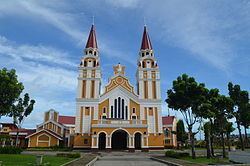
Palo is considered to be one of the most historical towns of Leyte. It is well known as the site of Gen. Douglas MacArthur's return to the Philippines together with Philippine and American military forces after a period of exile in 1944. Hill 522, a hill located near the town center, was the site of fierce fighting between Allied and Japanese forces during the Second World War. The metropolitan cathedral of the archdiocese, located right across Palo's municipal hall, was used as a hospital for wounded Filipino and American forces. A memorial now stands at the beach site where MacArthur and his troops landed, locally known as the MacArthur's Park. The first Gabaldon Building is also situated in Brgy. San Joaquin Palo, Leyte. It was inaugurated by President Sergio Osmeña.
Palo was also once the capital of Leyte. The town's Purissima Bridge was the first steel bridge built in the province.
In 1957, sitio Campitic was converted into a barrio, while barrio Baras-Candahug was divided into two: Baras and Candahug. Barrio Malirong was renamed as Libertad.
On November 8, 2013, Palo was severely struck by Typhoon Haiyan (Yolanda), which destroyed a large portion of Eastern Visayas and killed a number of residents in the town. On January 17, 2015, Pope Francis visited the town as part of his papal visit to the Philippines to meet with the surviving victims of the typhoon. He also blessed the Pope Francis Center for the Poor and met with priests, seminarians, other religious figures, and surviving victims of the typhoon at the Palo Cathedral before leaving Leyte.
Demographics
Literacy rate in Palo is 99.5%.
The town's native language is Waray-Waray, the major language and lingua franca in the Eastern Visayas region.
Economy
Palo is the seat of the 6.8-hectare Leyte Information and Communications Technology (ICT) Park and the 22-hectare Leyte Mikyu Economic Zone. The Leyte ICT Park hosts two BPOs while the Leyte Mikyu Ecozone is undergoing development.
The town thrives in both commerce and tourism, drawing a considerable number of visitors annually. It is home to the historic Municipal Building, previously serving as the Provincial Government of Leyte's seat. The town's location is optimally suited for trade and commercial activities, making it an ideal hub for both economic sectors.
The main source of income for most of the citizenry is the buying and selling of farm products and the production and fermentation of the local coconut wine "tuba".
Religion
Palo is believed to be a sacred place by clerical observers. It is the seat of the ecclesiastical province, the Archdiocese, where the Roman Catholic Archbishop resides in Bukid Tabor. One can find the Metropolitan Cathedral in Palo. Also, the seedbed of vocations to the priesthood is found at the Sacred Heart Seminary and the St. John the Evangelist School of Theology. Two Paloan nuns were also Superior Generals in their respective congregations. To date, there are 79 ordained priests and 106 nuns from the town alone.