
District 1st District Time zone PST (UTC+8) Area 128.9 km² | Barangays ZIP code 2918 Local time Tuesday 10:32 AM | |
 | ||
Weather 28°C, Wind NE at 16 km/h, 65% Humidity Points of interest Kapurpurawan Rock Formation, Cape Bojeador Lighthouse, Tanap Avis Falls | ||
Burgos is a fifth class municipality in the province of Ilocos Norte, Philippines, the most north-western town on the island of Luzon. According to the 2015 census, it has a population of 9,777 people.
Contents
- Map of Burgos Ilocos Norte Philippines
- History
- Geography
- Barangays
- Climate
- Demographics
- Local government
- Government seal
- Places of interest
- References
Map of Burgos, Ilocos Norte, Philippines
It was formerly known as Nagpartian and was renamed after the martyred priest José Burgos who was born in the Ilocos Region.
History
The town was first known as Nagparitan, the early inhabitants were called Mumburi and known as a wild and fierce people who prevented the Christianized natives from settling in the vicinity. When the Spaniards came to the area, the people staged a revolt, captured the priest and mutilated his body. Because of this incident, the Spaniards change the name of Nagparitan, meaning prohibit, to Nagpartian which means the place of slaughter.
In 1903, Nagpartian was then fused with the Municipality of Bangui because of the unstable condition due to low collection of government taxes. On February 28, 1914, by virtue of a legislative act, Nagpartian was renamed Burgos in honor of one of the three martyred priest, Fr, Jose Burgos. Seńor Juan Ignacio was the first Presidente Municipal of the town.
Majority of people in the municipality are engaged in the production of commercial crops like rice, garlic, tomato, mongo and corn. However, aside from producing agricultural products, most of them also venture into fishing, livestock and swine-raisin, rice milling, and cottage industries like furniture and hollow-blocks making, smelting, salt-making, and mat weaving.
The town is endowed with scenic and tourist-attracting shores or coastline – from plain white beaches in Barangays. Paayas and Bobon to rugged and sharp cliffs naturally formed through the centuries like Gagamtan Cliff in Barangay Bayog, and Kapur-purawan Cliff in Barangay Saoit. The Digging Falls is another pride of the town, with a beautiful cascade at the boundary of Barangays Ablan and Buduan, certainly a perfect place for local and foreign tourist to spend their summer escapade.
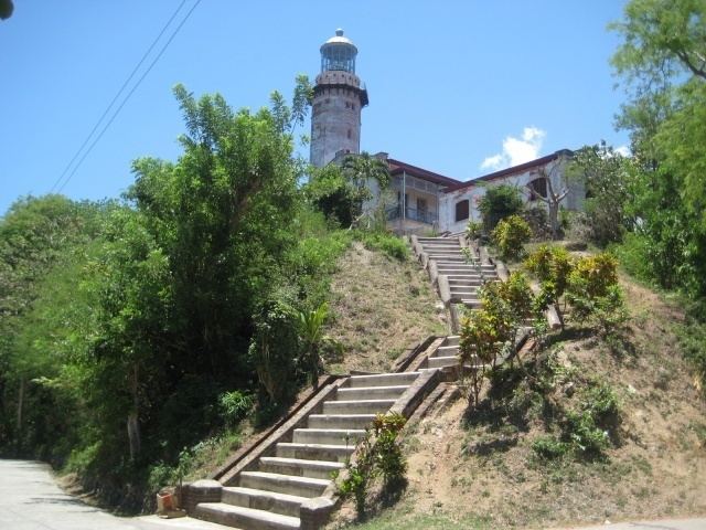
Another worth-mentioning tourist attraction is the historic Cape Bojeador Lighthouse, built during the latter part of the 19th century. Located on a top of a hill overlooking the vast expanse of the China Sea, it serves as a beacon light to passing ships and to local fishermen. Because of its high elevation, it offers travelers with a panoramic view of the rugged coastline of Burgos.
Geography
Burgos is bounded to the north by South China Sea; Bangui in the east and in the south, Pasuquin and Vintar. It has a total land area of 49.77 sq mi. It is situated in the north coast of Ilocos Norte. Burgos has the largest wind farm in the Philippines.
Barangays
Burgos is politically subdivided into 11 barangays.
Climate
Burgoes has a Tropical savanna climate with warm to hot weather year-round.
Demographics
In the 2015 census, the population of Burgos, Ilocos Norte, was 9,777 people, with a density of 76 inhabitants per square kilometre or 200 inhabitants per square mile.
Local government
As of the election 2013-2016, these are the elected officials of Burgos:
Government seal
Shield, derived from the Provincial Seal of Ilocos Norte.
Lighthouse, represents the Cape Bojeador Lighthouse, the main tourist attraction in the town.
Light, serves as guide to shipping vessels cruising the China Sea.
Mountain and Sea, depict the geographical location and the territorial limits of the municipality.