Country Philippines Area 192.29 km2 | Region Central Luzon Mayor Julius Cesar V. Vergara (Liberal Party) Population 259,267 (2007) | |
Colleges and Universities Nueva Ecija University of Science and Technology (Cabanatuan), Wesleyan University Philippines (Cabanatuan), Araullo University (Cabanatuan), Immaculate Conception College -Cabanatuan City (Cabanatuan), Nueva Ecija Colleges (Cabanatuan) Similar Nueva Ecija, Tarlac City, Gapan | ||
Cabanatuan, officially the City of Cabanatuan (Filipino: ; Ilokano: ; Kapampangan: Lakanbalen ning Cabanatuan), is a city in the province of Nueva Ecija, Philippines. It is the largest city in Nueva Ecija, and 5th in Central Luzon with a population of 272,676 in 2010.
Contents
Map of Cabanatuan
The city is popular for being home to more than 30,000 tricycles. It prides itself as the "Tricycle Capital of the Philippines" and its strategic location along the Cagayan Valley Road has made the city a major economic, educational, medical, entertainment and transportation center in Nueva Ecija and nearby provinces in the region such as Aurora and Bulacan. It has earned the moniker "Gateway to the North".
Cabanatuan remained as Nueva Ecijas capital until 1965 when the government created Palayan City as the new provincial capital. Nueva Ecijas old capitol and other government offices are still used and maintained by the provincial administration.
Araw ng cabanatuan activities
History

Cabanatuan was founded as Barrio of Gapan in 1750 and became a Municipality and capital of La Provincia de Nueva Ecija in 1780. Cabanatuan is the site of the historical "Plaza Lucero" and the Cabanatuan Cathedral, where General Antonio Luna was ambushed on his way to Palanan. Cabanatuan lost the title of provincial capital in 1850 when the capital of Nueva Ecija was moved to San Isidro, another historic town. It was only in 1917, when the Administrative code was enacted, that Cabanatuan was restored as capital of the Province. However, in 1965, Congress created Palayan City, which has been the capital ever since.

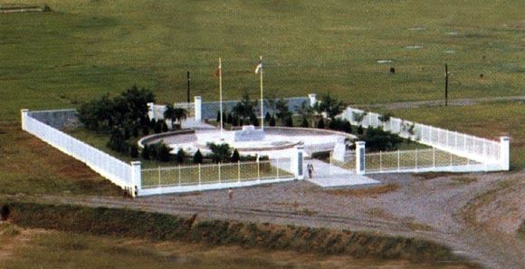
During World War II, the occupying Japanese built Cabanatuan Prison Camp, where many American soldiers were imprisoned, some of whom had been forced to endure the infamous Bataan Death March. In January 1945, elements of the U.S. Army 6th Ranger Battalion marched 30 miles (48 km) behind enemy lines to rescue the prisoners in what became known as the Raid at Cabanatuan. As a result of the raid, on January 30, 1945, victorious Filipino guerrillas and American troops of the U.S. Army 6th Ranger Battalion celebrated having obtained the freedom of 500 American POWs. Soon thereafter, Philippine and American forces re-established the presence of military general headquarters and military camp bases of the Philippine Commonwealth Army, Philippine Constabulary 2nd Infantry Regiment, and the United States Army here in Cabanatuan from February 1945 to June 1946 during the Allied Liberation. Before long, the combined Philippine Commonwealth and American armed forces, in cooperation with local guerrilla resistance fighters and Hukbalahap Communist guerrillas, had liberated Central Luzon from Japanese Imperial forces, a campaign that lasted from January until August 1945.
In 1957, the barrios of Mataas na Kahoy, Balangkare Norte, Balangkare Sur, Sapang Kawayan, Magasawang Sampaloc, Talabutab Norte, Talabutab Sur, Platero, Belen, Pecaleon, Piñahan, Kabulihan, Pasong-Hari, Balaring, Pulong Singkamas, Panaksak, Bravo, Sapang Bato, Burol, Miller, Tila Patio, Pula, Carinay, and Acacia were separated from Cabanatuan and constituted into a separate and independent municipality known as General Mamerto Natividad.
Cabanatuan was the epicenter of a massive earthquake at roughly 3 p.m. on July 16, 1990. The earthquake leveled some buildings, including the Christian College of the Philippines (Liwag Colleges) in the midst of class time. At 7.7 on the Richter scale, it killed 1,653 people.
Geography

Cabanatuan City is located in the rolling central plains of Luzon drained by the Pampanga River. The city is seated about 13 km west-southwest of the provincial capital Palayan City and 117 km north of Manila. The geographic coordinates of Cabanatuan City are 15° 29 22 N, 120° 58 14 E.
Economy
Cabanatuan City is the economic heart of Nueva Ecija and is the focus of a metropolitan area of more than 500,000 people. It is a vital financial center, being home to 60 banks and 74 non-bank financial institutions, corporate headquarters of some of the largest rural banks in Central Luzon, huge finance companies and a branch of the Bangko Sentral ng Pilipinas (BSP). It ranks as one of the most livable cities in the Philippines together with Makati City in terms of banking. The city is also a distribution center of different commodities, including agricultural produce, for the surrounding communities. Warehouses are a common sight around the city. Although Cabanatuan does not have significant manufacturing industries, its dynamic service sector together with the thriving agriculture drives the economy forward.
Attractions
Historical sites found in the city include:
