
 | ||
Unescap iru asian highway network caravan
The Asian Highway (AH) project, also known as the Great Asian Highway, is a cooperative project among countries in Asia and Europe and the United Nations Economic and Social Commission for Asia and the Pacific (ESCAP), to improve the highway systems in Asia. It is one of the three pillars of the Asian Land Transport Infrastructure Development (ALTID) project, endorsed by the ESCAP commission at its 48th session in 1992, comprising Asian Highway, Trans-Asian Railway (TAR) and facilitation of land transport projects.
Contents
- Unescap iru asian highway network caravan
- Asian highway network
- History
- Implications
- Regional perceptions of the project
- Routes
- Numbering and signage
- First car crossing
- Route log
- Distance by country
- References
Agreements have been signed by 32 countries to allow the highway to cross the continent and also reach to Europe. Some of the countries taking part in the highway project are India, Sri Lanka, Pakistan, China, Japan, South Korea and Bangladesh. Most of the funding comes from the larger, more advanced Asian nations like Japan, India and China as well as international agencies such as the Asian Development Bank.
The project aims to make maximum use of the continent's existing highways to avoid the construction of newer ones, except in cases where missing routes necessitate their construction. Project Monitor, an Asian infrastructure news website, has commented that "early beneficiaries of the Asian Highway project are the planners within the national land transport department of the participating countries [since] it assists them in planning the most cost-effective and efficient routes to promote domestic and international trade. Non-coastal areas, which are often negligible, are the other beneficiaries."
However, in the mid-2000s some transportation experts were sceptical about the viability of the project given the economic and political climate in both South and South-East Asia.
The Asian Highway Network is going to take over 2 projects, one is the AH 45 and the other is the new AH 45A. AH 45A is the new highway all over Asia from Tonghua to Sana'a.
Asian highway network
History
The AH project was initiated by the United Nations in 1959 with the aim of promoting the development of international road transport in the region. During the first phase of the project (1960–1970) considerable progress was achieved, however, progress slowed down when financial assistance was suspended in 1975.
ESCAP has conducted several projects in cooperation with AH member countries step by step after the endorsement of ALTID in 1992.
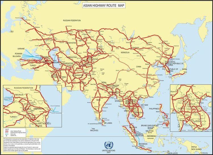
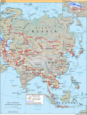
The Intergovernmental Agreement on the Asian Highway Network (IGA) was adopted on November 18, 2003, by the Intergovernmental Meeting; the IGA includes Annex I, which identifies 55 AH routes among 32 member countries totalling approximately 140,000 km (87,500 miles), and Annex II "Classification and Design Standards". During the 60th session of the ESCAP Commission at Shanghai, China, in April 2004, the IGA treaty was signed by 23 countries. By 2013, 29 countries had ratified the agreement.
Implications
The advanced highway network would provide for greater trade and social interactions between Asian countries, including personal contacts, project capitalizations, connections of major container terminals with transportation points, and promotion of tourism via the new roadways.
Regional perceptions of the project
According to Om Prakash, "It's an excellent step taken by ESCAP to gather all the Asian countries under one crown but the problem with this project is political disputes between some countries, notably Pakistan and Myanmar, which is delaying the project".
Routes
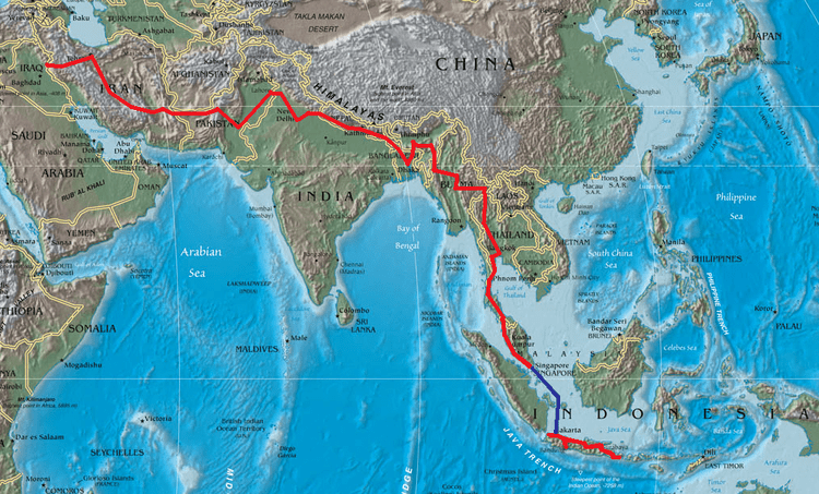
Route AH1 is proposed to extend from Tokyo to the border with Bulgaria west of Istanbul and Edirne, passing through both Koreas, China and other countries in Southeast, Central and South Asia. The corridor is expected to improve trade links between East Asian countries, India and Russia. To complete the route, existing roads will be upgraded and new roads constructed to link the network. US$25 billion has been spent or committed as of 2007, with additional US$18 billion needed for upgrades and improvements to 26,000 km of highway.
Numbering and signage
The project new highway route numbers begin with "AH", standing for "Asian Highway", followed by one, two or three digits. Single-digit route numbers from 1 to 9 are assigned to major Asian Highway routes which cross more than one subregion. Two- and three-digit route numbers are assigned to indicate the routes within subregions, including those connecting to neighbouring subregions, and self-contained highway routes within the participating countries. Route numbers are printed in the Latin script and Hindu-Arabic numerals and may simply be added to existing signage, like the E-road network.
The actual design of the signs has not been standardized, only that the letters and digits are in white or black, but the color, shape and size of the sign being completely flexible. Most examples feature a blue rectangular shield with a white inscription (similar to German Autobahn signage) with further examples of white on green and black on white rectangular shields.
First car crossing
What is believed to be the first car crossing of the full extent (East to West) of the new Asian Highway was achieved by Britons Richard Meredith and Phil Colley in 2007 driving an Aston Martin.
Following the AH1 and the AH5 from Tokyo (the Highway grid's furthest point East) to Istanbul (furthest West), they drove a total of 12089 km (7512 miles) before joining the European motorway network for another 3259 km (2025 miles) to London
Including ferry trips and customs clearance delays, the journey took 49 days and crossed 18 countries.
The completed route was verified by Aston Martin and the UN's Asian Commission (UNESCAP) in Bangkok, whose director of transport and tourism Barry Cable confirmed "I can warrant that, to my best knowledge, this was the first car to undertake this journey".
Eurowatch in London provided independent corroboration by tracking the car's location from satellite position reports and plotting the vehicle's location throughout the journey.
Meredith, a travel author and veteran of distance-driving events, agreed to make the attempt after attending the Asian Highway Treaty's "coming into force" ceremony in Bangkok on July 4, 2005.
He was lent an Aston Martin V8 Vantage which had previously been the personal transport of the company's chief executive Dr Ulrich Bez and recruited Phil Colley, a linguist and travel expert from Kennington, South London, to be his co-driver. The car was shipped out to Tokyo by the company and they set off on June 25.
Although the trip was facilitated by UNESCAP through its member nations, there were still extensive problems including enforced detours and interminable customs clearance delays in China, pot-holed roads in Kazakhstan and leaded-only fuel in Uzbekistan. In Tbilisi, Georgia, the journey car crashed after being left on a hillside with its handbrake unsecured.
When the record-setting car returned a welcome-home reception was staged by Aston Martin at the Park Lane Hotel in London and Meredith later received a civic award from his home town of Milton Keynes.
The car was sold at auction in December 2007 by Bonhams and the proceeds donated to UNICEF, the United Nations Children's Fund. In March 2008 a total collection of 83,000 euros was presented to UNICEF China for a campaign to reduce child deaths on the roads of Beijing.
Route log
Single-digit routes run across the whole continent:
10-29 and 100-299 are assigned to Southeast Asia:
30-39 and 300-399 are assigned to East Asia and Northeast Asia:
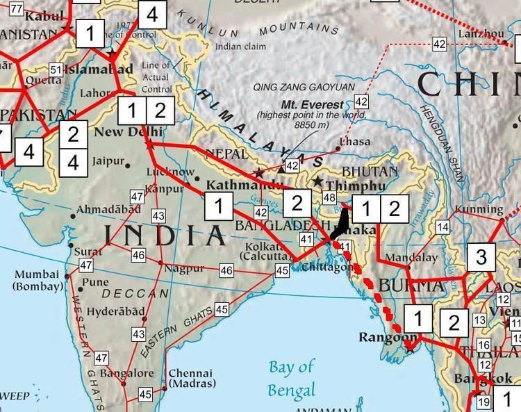
40-59 and 400-599 are assigned to the Indian Subcontinent:
60-89 and 600-899 are assigned to North Asia, Central Asia and Southwest Asia:
Distance by country
The planned network runs a total of 140,479 kilometres (87,290 mi).