
Length 445.2 km | Constructed 1956 | |
 | ||
Existed: August 7, 1947 by FHWA1956 – present Counties | ||
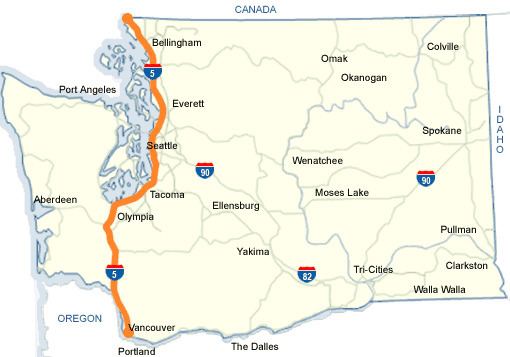
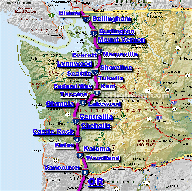
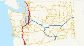
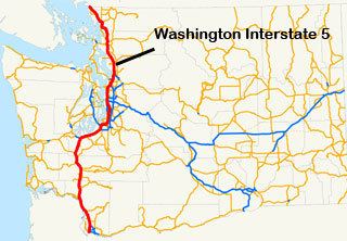
Interstate 5 in Washington (I-5) is a 276.62-mile (445.18 km) highway in the U.S. state of Washington that extends from its border with Oregon to its border with Canada. Serving the cities of Vancouver, Kelso, Chehalis, Centralia, Olympia, Tacoma, Seattle, Everett, Mount Vernon, and Bellingham, it is the main route between Portland, Oregon, and Vancouver, British Columbia.
Contents
- Vancouver to Tumwater
- Tumwater to Tukwila
- Tukwila to Shoreline
- Seattle express lanes
- Shoreline to Everett
- Everett to Mount Vernon
- Mount Vernon to Blaine
- History
- Kelso to Centralia
- Seattle
- Seattle to Everett
- Downtown Seattle express lanes
- References
It is the only interstate to traverse the whole north–south length of Washington, but the undivided highways U.S. Route 97 and U.S. Route 395 do also. I-5 is also the only north–south primary interstate highway in Washington. The road is the busiest in the state; an estimated 240,000 motorists use the road daily. The second busiest is I-405 at 201,000.
Vancouver to Tumwater
I-5 enters Washington at the Interstate Bridge over the Columbia River between Portland and Vancouver. It initially heads north through Vancouver and intersects SR 14, the first segment of SR 501, and SR 500 until the interchange with I-205 in Salmon Creek, where the freeway begins a turn to the northeast. I-5 closely follows the alignment of old U.S. Route 99, and in some locations the US 99 alignment has become I-5. The interstate passes the Vancouver branch of Washington State University. Southeast of Ridgefield, the highway intersects SR 502 and the second segment of SR 501 before continuing north along the Columbia River to Woodland.
In Woodland, I-5 intersects SR 503 and starts to curve northwest towards Longview and Kelso. At Longview Junction, east of Longview, I-5 intersects SR 432 and continues north to Kelso. Here it intersects SR 4, formerly US 830, and SR 431 before curving northeast towards Castle Rock. In Castle Rock, the freeway intersects SR 411, and SR 504, which connects I-5 with Mount St. Helens, and Spirit Lake. From Castle Rock, the highway goes north to Napavine and intersects SR 506 and SR 505 before becoming concurrent with US 12 and continuing north to intersect SR 508. After the intersection, I-5 and US 12 go into Chehalis, where the highway intersects SR 6.
After leaving Chehalis, I-5/US 12 enters Centralia and intersects SR 507 before splitting from US 12 north of the city. As the freeway continues north towards Olympia, it intersects SR 121, which connects the highway with Millersylvania State Park and loops back to I-5. As the freeway enters Tumwater, it passes the Olympia Airport before intersecting the northern terminus of US 101.
Tumwater to Tukwila
As I-5 leaves the US 101 interchange, the highway curves east and forms the southern boundary of Olympia. The highway also goes across Capitol Lake and intersects Capitol Way, which connects the freeway to the Washington State Capitol. After leaving Olympia, I-5 goes in a northeastern direction into Lacey, where it intersects SR 510. After passing Nisqually, the highway enters Du Pont, where it enters Fort Lewis. After passing Camp Murray and American Lake, the freeway comes to the proposed western terminus of SR 704, passes McChord Air Force Base, and enters Lakewood.
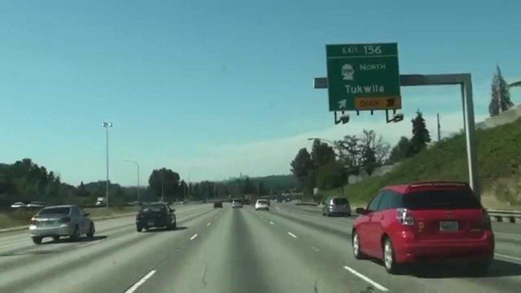
In Lakewood, I-5 intersects SR 512 and continues into Tacoma, where the freeway passes the Tacoma Mall and intersects major highways, such as SR 16, I-705, SR 7, and SR 167 before going east through the Puyallup Indian Reservation at Fife. In Fife, the highway intersects SR 99, a small portion of US 99 through the Puget Sound region, and then enters Federal Way. Here the freeway intersects the western terminus of SR 18, which has been proposed to be renumbered to I-605 after being upgraded to Interstate standards.
After also intersecting SR 516, the highway passes Angle Lake, the Seattle-Tacoma International Airport, and Westfield Southcenter before going into an interchange with I-405 and SR 518. SR 518 connects I-5 to the Seattle-Tacoma International Airport, and I-405 bypasses I-5 through Seattle.
Tukwila to Shoreline
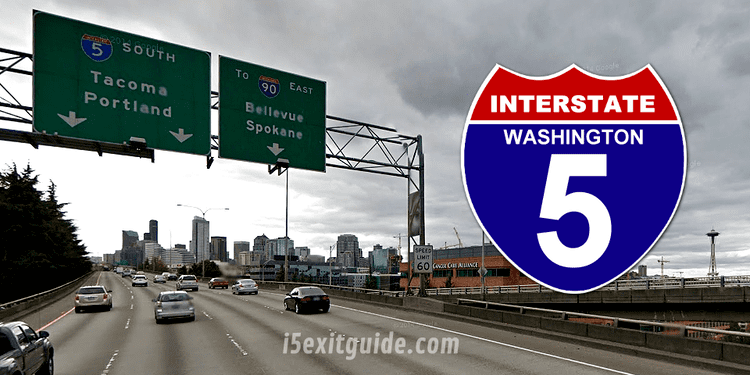
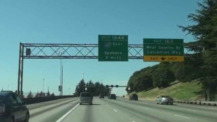
From the I-405/SR 518 interchange, I-5 goes north and intersects SR 599, which connects I-5 to SR 99, and SR 900. From the interchanges, the highway passes Boeing Field and the West Seattle Bridge before having a large interchange with I-90. After the interchange, I-5 intersects SR 519 and enters Seattle.
In downtown Seattle, I-5 becomes a tunnel passing under the Washington State Convention and Trade Center and Freeway Park. Once I-5 begins to rise from the tunnel, it passes over the I-5 Colonnade and then intersects the western terminus of SR 520, which goes to Bellevue via the Evergreen Point Floating Bridge. From the interchange with SR 520, the freeway goes north along the Ship Canal Bridge over the Lake Washington Ship Canal and passes the University of Washington before entering Northgate.
Within the neighborhood of Northgate, the highway intersects SR 522 and merges with the I-5 express lanes at the Northgate Mall. From the Northgate Mall, I-5 goes north into Shoreline and intersects SR 523 and passes a King County Metro Transit base before intersecting SR 104 and entering Mountlake Terrace.
Seattle express lanes
Interstate 5 has 7.14 miles (11.49 km) of reversible express lanes within Seattle. The express lanes begin after the Yesler Way bridge and tunnel under the northbound lanes of I-5 and intersect Cherry Street/Columbia Street. From the interchange, the express lanes intersect Mercer Street and then cross the Ship Canal Bridge. The express lanes are on the lower deck below the lanes of I-5. Near the end of the bridge is a reversible ramp that accesses Northeast 42nd Street. After the bridge ends, the express lanes continue northbound and intersect with Ravenna Boulevard, Lake City Way, and Northeast 103rd Street/1st Avenue Northeast. Finally, the lanes merge with I-5 in Northgate just north of the Northgate Mall.
The express lanes are open to all traffic; however, some ramps are designated for HOV vehicles only to assist with traffic flow and mitigate constrained space. These ramps include Cherry Street/Columbia Street/5th Avenue, Ravenna Boulevard, and Pike Street/Downtown Seattle Transit Tunnel. The express lanes carry northbound traffic from 12pm to 11pm Monday through Friday and 2pm to 11pm Saturday and Sunday. They carry southbound traffic from 5 am to 11am Monday through Friday and from 7am to 1pm Saturday and Sunday.
Shoreline to Everett
After leaving Shoreline and intersecting SR 104, I-5 enters Snohomish County and Mountlake Terrace. From the interchange, the highway passes Lake Ballinger and intersects SR 524 before reaching the Alderwood Mall. Next to the mall, the freeway intersects SR 525 and I-405. From the interchange, I-5 passes Martha Lake, intersects SR 96, and passes Silver Lake before reaching the interchange between I-5, SR 99, SR 526, and SR 527 near the Everett Mall. SR 99 is part of Old US 99, SR 526 connects I-5 to the Boeing Everett Factory, and SR 527 connects Bothell with Everett.
After leaving the interchange, I-5 intersects 41st Street at a single-point urban interchange, the only one in the area. From the interchange, the freeway intersects SR 529 and then SR 529 Spur and US 2.
Everett to Mount Vernon
After leaving downtown Everett and the US 2/SR 529 Spur interchange, I-5 goes north across the Snohomish River and curves northeast to an interchange with SR 529. North of the interchange, the freeway enters Marysville and intersects SR 528. The highway passes the Tulalip Resort Casino at Quil Ceda, commonly known as the Quil Ceda Creek Casino, the Marysville Water Tower, Quil Ceda Village, the Tulalip Resort Casino and Tulalip Hotel, and Lakewood Crossing before intersecting SR 531 and leaving Marysville. From the Marysville City limits, I-5 passes Smokey Point and goes northwest to Island Crossing, where the highway intersects SR 530, which connects the freeway to Arlington, Darrington, and Rockport.
After the interchange, I-5 travels over the Stillaguamish River and passes Silvana before intersecting SR 532, which goes west to Stanwood and Camano Island. As the highway curves northwest, the freeway enters Skagit County. Once in Skagit County, I-5 goes into Conway, where it intersects SR 534, which goes east to serve Big Lake. From Conway, the freeway goes north into Mount Vernon, where I-5 intersects SR 536, which serves as a shortcut to Anacortes, via SR 20 and SR 20 Spur.
Mount Vernon to Blaine
After leaving downtown Mount Vernon, the freeway intersects SR 538, which serves the Skagit Valley College and Clear Lake (via SR 9). After the interchange, the highway crosses the Skagit River, where part of the bridge collapsed on May 23, 2013, leaving a gap in the highway until a temporary bailey bridge span was built and opened on June 19. In September it was replaced with a more permanent span. On the other side of the river it continues north through Burlington. After passing the Cascade Mall, I-5 intersects SR 20, which goes west to Anacortes (via SR 20 Spur), Deception Pass, Whidbey Island, and Discovery Bay and SR 20 goes east to Okanogan, Omak, and Newport. The freeway also intersects SR 11, which serves Edison, Bow, Samish Island, and Bellingham.
From the interchange, I-5 travels north and curved west on the shoreline of Lake Samish north of Alger, which is also the point where the freeway enters Whatcom County. After traveling west, I-5 curves north again and intersects SR 11 before entering Bellingham. In Bellingham, the highway intersects SR 542, which goes to Mount Baker, and SR 539, which goes to Lynden and British Columbia. The freeway passes the Bellis Fair Mall, Bellingham International Airport, and Ferndale before intersecting SR 548, which serves Blaine. Once in Blaine, I-5 intersects SR 543, which leads to the truck and freight border crossing. The freeway then intersects SR 548 again and then crosses the Canadian border into British Columbia as Highway 99 at the Peace Arch.
History
As part of the state's first connected state highway system, the Washington State Legislature designated the Pacific Highway between Vancouver and Blaine in 1913. The State Highway Board selected a route that would connect the main cities of Western Washington, which were Vancouver, Olympia, Tacoma, Seattle, Everett, and Bellingham. In 1923, by which time the entire road had been improved, the highway became State Road 1 (Primary State Highway 1 after 1937), but retained its name. By that time, most of the route of Interstate 5 became US 99, which was established in 1926.
Later in 1956, President Dwight D. Eisenhower signed the Federal-Aid Highway Act of 1956 which started the construction of Interstate Highways. In 1968, US 99 was removed from the system entirely, a year before the last portion of Interstate 5 opened on November 14, 1969. Legally, the Washington section of I-5 is defined at Washington Revised Code § 47.17.020. Several projects are currently ongoing and have been completed in the recent years on I-5.
Kelso to Centralia
During the past two decades, parts of the interstate have been periodically inundated by floodwaters as a result of area storms. Floods in November 1990, February 1996, December 2007, and January 2009 each caused temporary closures of I-5 between the Kelso-Longview and Chehalis-Centralia areas. The causes of this problem, as noted by the United States Army Corps of Engineers, are attributable to "decades of clear-cut logging, modifications of waterways, and destruction of natural flood control features within the Chehalis River basin."
The December 3, 2007, flood closed a 20-mile (32 km) section of the interstate for four days. The Washington State Department of Transportation recommended a 440-mile (710 km) detour between Portland and Seattle, by way of I-90, I-82, and I-84, adding 270 miles (430 km) to the 170-mile (270 km) trip.
The January 7, 2009 flood closed a 20-mile (32 km) section of the interstate for several days. The Washington State Department of Transportation was unable to offer a detour since all three main east/west passes were also closed due to severe mudslide and avalanche danger.
Seattle
South of the Ship Canal Bridge Interstate 5 separates the Eastlake and Cascade neighborhoods from the Capitol Hill neighborhood, and separates Downtown Seattle from the Capitol Hill and First Hill neighborhoods. Its construction necessitated the demolition of significantly developed areas and cut off walking commutes to downtown for many First Hill residents, who "were by far the most vociferous critics of the proposed route," but far from the only ones. Architect Paul Thiry said in the early 1970s, "It was with the Freeway, cutting through the very heart of the city, that Seattle began taking one of its wrong turns and started to lose its identity as a city." He proposed a lid extending from Columbia Street north to Olive Way, roughly the entire length of downtown.
Among the buildings torn down in the Downtown-First Hill area to build the freeway was the Hotel Kalmar at Sixth Avenue and James Street (built 1881 as the Western Hotel, demolished 1962), the last of Seattle's pioneer-era hotels, predating the Great Seattle Fire, and Seattle's then-oldest public building, the Seventh Avenue Fire Hall (built 1890, demolished c. 1962).
In the years since the freeway's construction, Seattle has made several efforts to stitch back together pedestrian routes disrupted by the freeway, achieving part of Thiry's proposed "lid". The most visible of these efforts are Freeway Park (opened 1976), built as a lid over the freeway and connecting Downtown to First Hill, and the Washington State Convention and Trade Center (built 1982-1988) adjacent to Freeway Park, also bridging the freeway. The 7.5-acre (30,000 m2) I-5 Colonnade mountain bike park (opened 2007) uses the freeway as a roof and reconnects Eastlake to Capitol Hill.
On Interstate 5, the only planned improvement on the express lanes is a direct connection to the future SR 520 HOV lanes, to be constructed as part of the Evergreen Point Floating Bridge replacement project.
Seattle to Everett
The 19.7 miles (31.7 km) section between Seattle and Everett was opened on February 3, 1965 by Miss Sno-King Rose Clare Menalo of Meadowdale High School.
Everett to Mount Vernon
The portion of I-5 from US 2 / SR 529 Spur in Everett to SR 528 in Marysville opened at a ribbon-cutting ceremony on May 14, 1969 by Devvie Herivel, Miss Everett, and Katherine Smith, Miss Marysville. This was the last portion of Interstate 5 from California to Canada that was opened, free of traffic lights and draw bridges. The stretch of I-5 from Marysville to Mount Vernon was already opened as a 4-lane divided highway without overpasses.
On May 23, 2013, the northbound span of the I-5 Skagit River bridge between Mt. Vernon and Burlington collapsed.
Downtown Seattle express lanes
The entire highway is in Seattle, King County.