
Counties: King | Length 20.63 km West end I‑5 in Seattle | |
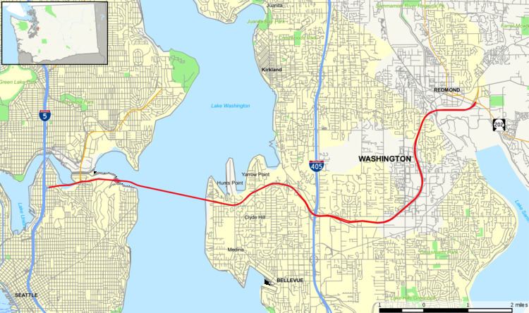 | ||
State Route 520 is a state highway and freeway in the U.S. state of Washington. It extends 12.82 miles (20.63 km) from Seattle in the west to Redmond in the east.
Contents
- Map of WA 520 Washington USA
- Route description
- Planning
- Construction
- State Route 920
- Completed projects
- Corridor improvement program
- Other planned improvements
- Proposed improvements
- Ghost ramps
- Exit list
- References
Map of WA-520, Washington, USA
Route description
SR-520 originates at Interstate 5 in Seattle at the north end of Capitol Hill just south of Roanoke Park.
It bridges Portage Bay on a viaduct, crosses through the Montlake neighborhood, and continues east on a causeway through the marshlands of the Washington Park Arboretum and across Foster Island. From there it crosses Lake Washington on the tolled Evergreen Point Floating Bridge (2016) to Medina. At 7,710 feet (2,350 m), it is the longest floating bridge in the world.
From Medina, it traces the border between Hunts Point and Yarrow Point to the north, and Clyde Hill to the south. Intersecting with Interstate 405 in Bellevue, it then runs into Redmond. It bisects the Microsoft campus, passes Nintendo of America headquarters and crosses the Sammamish River and Bear Creek, before ending at a junction with State Route 202. A set of ramps connecting SR-520 to Avondale Road NE were completed in 1996.
The original name of the freeway in planning documents was the Roanoke Expressway and later the Roanoke Freeway, due to its terminus at Interstate 5 near Roanoke Street and Roanoke Park in Seattle.
Planning
SR-520 first appears on planning maps in the late 1950s. It is not in the 1956 Comprehensive Plan of Seattle, in which the preferred second bridge crossing of Lake Washington connects Sand Point and Juanita (now part of Kirkland).
In the 1963 and 1967 revisions of the King County Streets and Highways Plan, SR-520 appears in its entirety. The segment from I-5 to I-405 is shown as existing or "to be improved"; the segment from I-405 to SR-202 is shown as "proposed".
The 1967 Puget Sound Regional Council of Governments recommended freeway system omits the segment from I-405 to SR-202, replacing it with a freeway from the Sand Point-Kirkland bridge (then proposed as a third Lake Washington crossing) along the current route of SR-908, deviating southward near West Lake Sammamish Parkway to end at the current SR-520 terminus. In this plan, SR-520 ends at I-405.
All planning maps from 1974 onward show the SR-520 routing as it currently exists.
Construction
With the completion of the original Evergreen Point Floating Bridge in August 1963, SR-520 opened to traffic. Originally, it was legislatively defined as PSH-1 EP (Primary State Highway 1, Evergreen Point branch). The road was signed as PSH-1 without the branch designation.
When the new numbering system for Washington highways took effect in 1964, SR-520 ran from I-5 to the junction of Lake Washington Boulevard NE and Lincoln Avenue (now Bellevue Way).
The segment from I-405 to 148th Avenue NE opened in the early 1970s. In the mid-1970s, the segment between West Lake Sammamish Parkway and SR-202 opened with the route number State Route 920 as a Super-2 freeway. This segment was widened to a divided 4-lane freeway by 1990.
The final segment of SR-520 between 148th Avenue NE and West Lake Sammamish Parkway opened c. 1979. At this time, SR-920 was redesignated as SR-520.
In 1973, the right-side shoulder of westbound SR-520 from Bellevue Way to the Evergreen Point Floating Bridge was converted for use as a transit-only lane, so that buses could bypass the tollbooths for the bridge. The existing general-purpose lanes were narrowed to accommodate the conversion. In the late 1980s, the lane was redesignated as a HOV lane for carpools of 3 or more, in addition to transit use.
In the 1990s, both sides of SR-520 from the I-405 interchange to W Lake Sammamish Parkway were widened to add a HOV lane on both sides, and collector-distributor lanes were added from NE 40th Street to W Lake Sammamish Parkway. A new interchange was built at NE 40th Street to accommodate expansion of the Microsoft and Nintendo of America corporate campuses.
The Evergreen Point Floating Bridge was replaced by a new floating bridge at the same site in 2016.
State Route 920
State Route 920 was a temporary designation of what is now part of State Route 520 between West Lake Sammamish Parkway - known at the time as State Route 901, and State Route 202 in Redmond. The original roadway was a 4 lane undivided link road between the two highways. SR 520 had only been completed to 148th Ave NE when SR 920 was constructed. When the missing link between 148th Ave NE and SR 901 was completed in the early 1980s, SR 920 was replaced by the SR 520 designation. However upon completion, there was a short section crossing SR 901 where SR 520 narrowed to one lane, and then immediately back to two. This section of SR 520 was widened and a new interchange was built at the junction of SR 520, SR 202, and Avondale Road - the former eastern terminus of SR 920.
Completed projects
Corridor improvement program
Since 2011, the Washington State Department of Transportation has undertaken a $4.56 billion megaproject to improve the State Route 520 corridor, known as the SR 520 Bridge Replacement and HOV Program, through the replacement of existing structures and widening the freeway to accommodate high-occupancy vehicle lanes in the center of the roadway. The project entails replacement of the Evergreen Point Floating Bridge with a newer bridge at the same location, which was completed in April 2016, as well as new approach structures and interchanges on both sides of Lake Washington. The project also built facilities for buses and non-motorized modes (mainly pedestrians and cyclists), including median bus stations on the Eastside, new park lids on the Eastside, and a new mixed-use bike and pedestrian trail on the bridge. Initially, only the floating bridge replacement, replacement of the west approaches and Eastside bus station replacement and lid construction; the 2015 session of the Washington State Legislature approved funding for the remaining portion in Seattle, mainly the rebuilding of the Montlake Boulevard interchange, replacement and widening of the Portage Bay Bridge, a parallel span for the Montlake Bridge, and new freeway lids in Roanoke and Montlake.
As part of the funding of the program, electronic tolling began on the old floating bridge on December 29, 2011.
Other planned improvements
Proposed improvements
Ghost ramps
SR 520 has a set of ghost ramps in the marshlands of Washington Park Arboretum. They are often referred to as "ramps to nowhere". However, one ramp is currently used for the on ramp to SR 520 Eastbound. The others are unused. They were originally part of a plan to build the R. H. Thomson Expressway which would have cut through the arboretum and down through Seattle towards the I-90/I-5 interchange. Citizens rallied a freeway revolt against the plan on May 4, 1969. Construction near the Arboretum later continued but citizen protest eventually won out and the plan was dropped in 1971.
The freeway revolt that stopped the R. H. Thomson Expressway had its origins in opposition to SR 520 itself. Architect Victor Steinbrueck, writing in 1962, objected to the "naked brutality of unimaginative structures such as this proposed crossing of Portage Bay, which eliminates fifty houseboats while casting its shadow and noise across this tranquil boat haven."
In 2013 the Washington State Department of Transportation announced plans to dismantle the ghost ramps. To commemorate the ramps and protest their demolition, a local art collective created an installation, Gate to Nowhere, on one of the ramps in 2014. The piece consists of a layer of reflective acrylic wrapping a pair of support columns.
In the spring of 2016, some of the SR 520 ghost ramps have begun to be dismantled to make way for the construction of a new causeway linking the new floating bridge to the mainland.
Exit list
The entire highway is in King County.